
Olivehurst, California facts for kids
Quick facts for kids
Olivehurst, California
|
|
|---|---|

Location in Yuba County and the state of California
|
|

Olivehurst, California
Location in the United States
|
|
| Country | |
| State | |
| County | Yuba |
| Area | |
| • Total | 7.473 sq mi (19.354 km2) |
| • Land | 7.473 sq mi (19.354 km2) |
| • Water | 0 sq mi (0 km2) 0% |
| Elevation | 66 ft (20 m) |
| Population
(2020)
|
|
| • Total | 16,595 |
| • Density | 2,220.66/sq mi (857.45/km2) |
| Time zone | UTC-8 (Pacific (PST)) |
| • Summer (DST) | UTC-7 (PDT) |
| ZIP code |
95961
|
| Area code(s) | 530 |
| FIPS code | 06-53714 |
| GNIS feature ID | 1659301 |
Olivehurst, once called Denniston, is a community located in Yuba County, California, United States. It is a census-designated place (CDP), which means it's a populated area that is counted by the census but isn't officially a city.
In 2020, about 16,595 people lived in Olivehurst. It is located about 4 miles (6.4 km) south-southeast of Marysville.
Contents
History of Olivehurst
Olivehurst was first settled by many people from the Midwest during the Great Depression. They came looking for good land, jobs, and a better future. These settlers were often called "Okies". This term was originally for people from Oklahoma who left their homes because of the "dust bowl" during the Great Depression.
Some streets in Olivehurst are even named after cities in Oklahoma. These "Okies" followed other groups of migrant workers. These groups included people of Chinese, Japanese, Filipino, Mexican, and Native American backgrounds.
For a long time, the economy of Olivehurst was mostly about agriculture (farming). Since the 1950s, more jobs have been in factories and manufacturing. Today, many residents work outside of Olivehurst. This is called a "commuter economy." A post office opened in Olivehurst in 1941.
Geography and Location
Olivehurst is located at 39°05′44″N 121°33′08″W / 39.09556°N 121.55222°W. The community covers a total area of about 7.5 square miles (19.4 square kilometers). All of this area is land.
Olivehurst is close to where two rivers meet: the Yuba River and the Feather River. In 1987, a big flood from the Yuba River caused a lot of damage to Olivehurst. A levee (a wall built to stop floods) broke during this flood. Another flood in 1997 also caused damage. After these floods, some businesses left the area.
Population and People
Population in 2010
At the 2010 census, Olivehurst had 13,656 people. Most people lived in homes, with only a small number in group living situations.
The population included people from many different backgrounds:
- About 62.5% were White.
- About 2.4% were African American.
- About 2.9% were Native American.
- About 5.7% were Asian.
- About 0.4% were Pacific Islander.
- About 19.2% were from other races.
- About 6.9% were from two or more races.
- About 36.6% of the people were Hispanic or Latino.
The average household in Olivehurst had about 3.30 people. The average family size was about 3.71 people. About 31.8% of the population was under 18 years old. The average age in Olivehurst was about 29.9 years.
Population in 2000
At the 2000 census, Olivehurst had 11,061 people. The population density was about 2,208.9 people per square mile.
The racial makeup of the community was:
- About 67.29% White.
- About 1.65% African American.
- About 3.67% Native American.
- About 5.06% Asian.
- About 0.17% Pacific Islander.
- About 15.52% from other races.
- About 6.63% from two or more races.
- About 24.95% of the people were Hispanic or Latino.
About 41.5% of households had children under 18 living with them. The average household size was 3.17 people. The average family size was 3.58 people. The median age was 30 years.
Education
Olivehurst is part of the Marysville Joint Unified School District. The community has several elementary schools. It is also home to Lindhurst High School, which is one of two high schools in the district.
Notable People
- Phil Baugh - a talented musician.
Images for kids
-
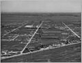
Olivehurst in 1940

See also
 In Spanish: Olivehurst para niños
