New Haven, New York facts for kids
Quick facts for kids
New Haven, New York
|
|
|---|---|

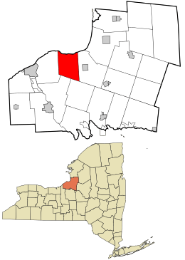
Location in Oswego County and the state of New York.
|
|
| Country | United States |
| State | New York |
| County | Oswego |
| Area | |
| • Total | 33.41 sq mi (86.54 km2) |
| • Land | 31.10 sq mi (80.54 km2) |
| • Water | 2.31 sq mi (6.00 km2) |
| Elevation | 420 ft (128 m) |
| Population
(2010)
|
|
| • Total | 2,856 |
| • Estimate
(2016)
|
2,835 |
| • Density | 91.16/sq mi (35.20/km2) |
| Time zone | UTC-5 (Eastern (EST)) |
| • Summer (DST) | UTC-4 (EDT) |
| ZIP code |
13121
|
| Area code(s) | 315 |
| FIPS code | 36-50342 |
| GNIS feature ID | 0979265 |
New Haven is a town located in Oswego County, New York, in the United States. In 2010, about 2,856 people lived there.
Contents
History of New Haven
Long ago, the area where New Haven is now was known as "Vera Cruz."
The Town of New Haven was officially created in 1813. It was formed from a part of the nearby Town of Mexico. This happened even before Oswego County itself was fully established.
Geography and Location
New Haven covers a total area of about 33.5 square miles (86.5 square kilometers). Most of this area, about 31.2 square miles (80.5 square kilometers), is land. The rest, about 2.3 square miles (6.0 square kilometers), is water.
The northern border of the town is along the shore of Lake Ontario.
Population Facts
| Historical population | |||
|---|---|---|---|
| Census | Pop. | %± | |
| 1820 | 1,590 | — | |
| 1830 | 1,410 | −11.3% | |
| 1840 | 1,737 | 23.2% | |
| 1850 | 2,015 | 16.0% | |
| 1860 | 2,073 | 2.9% | |
| 1870 | 1,764 | −14.9% | |
| 1880 | 1,713 | −2.9% | |
| 1890 | 1,557 | −9.1% | |
| 1900 | 1,408 | −9.6% | |
| 1910 | 1,461 | 3.8% | |
| 1920 | 1,256 | −14.0% | |
| 1930 | 1,116 | −11.1% | |
| 1940 | 1,194 | 7.0% | |
| 1950 | 1,259 | 5.4% | |
| 1960 | 1,478 | 17.4% | |
| 1970 | 1,845 | 24.8% | |
| 1980 | 2,421 | 31.2% | |
| 1990 | 2,778 | 14.7% | |
| 2000 | 2,930 | 5.5% | |
| 2010 | 2,856 | −2.5% | |
| 2016 (est.) | 2,835 | −0.7% | |
| U.S. Decennial Census | |||
In the year 2000, there were 2,930 people living in New Haven. These people lived in 1,063 different homes. About 781 of these homes were families.
Most of the people in New Haven were White (98.40%). There were also small numbers of African American, Native American, and Asian residents. About 0.89% of the population was Hispanic or Latino.
Many homes (39%) had children under 18 living there. Most homes (59.5%) were married couples living together. The average home had about 2.76 people, and the average family had about 3.19 people.
The population included people of all ages. About 29.4% were under 18 years old. The median age was 34 years, meaning half the people were younger than 34 and half were older.
Communities and Places in New Haven
- Austin Corners – This is a small area in the southeastern part of the town.
- Butterfly Corners ("Butterfly") – A small village located in the eastern part of the town.
- Cummings Bridge ("Cummings Mills") – Another spot found in the southeastern corner of New Haven.
- Demster – A small village located north of the main New Haven village, along Route 6.
- Demster Beach – A small village right on the shore of Lake Ontario.
- Hickory Grove – A location also found on the shore of Lake Ontario.
- Johnsons Corners – This is a place in the southeastern part of the town.
- New Haven – This is the main village of New Haven, located on Route 104. It used to be called "Gay Head."
- New Haven Station – A location just north of the main New Haven village.
- Pleasant Point Crossing ("Pleasant Point") – A small village located west of Demster.
- Sala – A small village near the southern border of the town, southwest of South New Haven.
- South New Haven – A small village located southwest of the main New Haven village.
- Vermillion – A small village on the southern border of the town, south of Butterfly Corners.
See also
 In Spanish: New Haven (Nueva York) para niños
 | Claudette Colvin |
 | Myrlie Evers-Williams |
 | Alberta Odell Jones |

