New Hope, Alabama facts for kids
Quick facts for kids
New Hope, Alabama
|
|
|---|---|

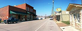
New Hope's Main Street
|
|

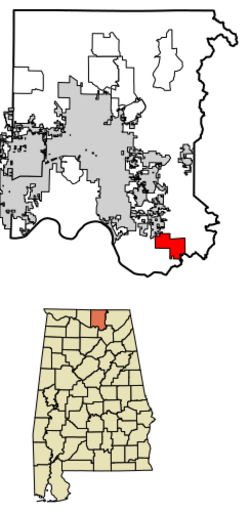
Location in Madison County, Alabama
|
|
| Country | United States |
| State | Alabama |
| County | Madison |
| Incorporated | September 5, 1956 |
| Area | |
| • Total | 8.715 sq mi (22.572 km2) |
| • Land | 8.658 sq mi (22.423 km2) |
| • Water | 0.057 sq mi (0.149 km2) |
| Elevation | 614 ft (187 m) |
| Population
(2020)
|
|
| • Total | 2,889 |
| • Estimate
(2023)
|
2,927 |
| • Density | 333/sq mi (128.5/km2) |
| Time zone | UTC−6 (Central (CST)) |
| • Summer (DST) | UTC−5 (CDT) |
| ZIP Code |
35760
|
| Area code(s) | 256 and 938 |
| FIPS code | 01-54168 |
| GNIS feature ID | 2404361 |
New Hope is a city located in Madison County, Alabama, in the United States. It is part of the larger Huntsville-Decatur Combined Statistical Area. In 2020, about 2,889 people lived in New Hope.
Contents
History of New Hope
New Hope has an interesting past with a few name changes! It was first settled in 1829 by William Cloud, who called it "Cloud's Town."
From Vienna to New Hope
In 1832, the town officially became a city and was named "Vienna." During the American Civil War, in 1864, a Union Army leader named Lieutenant Colonel Alfred Reed took control of Vienna. The town was later burned down by the Union Army because of ongoing fights with local fighters.
After the fire, only the post office and a special meeting hall (called a Masonic Lodge) were left. Since there was already another post office named Vienna in Alabama, the rebuilt town had to choose a new name. In 1883, it was officially named "New Hope," taking its name from the New Hope Methodist Church.
The very first settlement, Cloud's Town, was actually a few miles away in an area now known as Cloud's Cove.
Geography of New Hope
New Hope is found in the southeastern part of Madison County, Alabama. It is located along U.S. Route 431.
Location and Size
The city is about 19 miles southeast of Huntsville and the same distance northwest of Guntersville.
New Hope covers a total area of about 8.7 square miles (22.6 square kilometers). Most of this area is land, with a small part being water.
People of New Hope
New Hope has grown over the years. Here's a look at how its population has changed:
| Historical population | |||
|---|---|---|---|
| Census | Pop. | %± | |
| 1880 | 146 | — | |
| 1900 | 208 | — | |
| 1910 | 301 | 44.7% | |
| 1920 | 315 | 4.7% | |
| 1930 | 446 | 41.6% | |
| 1960 | 953 | — | |
| 1970 | 1,300 | 36.4% | |
| 1980 | 1,546 | 18.9% | |
| 1990 | 2,248 | 45.4% | |
| 2000 | 2,539 | 12.9% | |
| 2010 | 2,810 | 10.7% | |
| 2020 | 2,889 | 2.8% | |
| 2023 (est.) | 2,927 | 4.2% | |
| U.S. Decennial Census 2020 Census |
|||
New Hope did not appear on the U.S. Census in 1890, 1940, or 1950. This might be because its official city status (incorporation) ended and was not renewed until before 1960.

Population in 2020
In 2020, there were 2,889 people living in New Hope. There were 1,177 households and 795 families. Most of the people living in New Hope were White (about 88%). Other groups included Native American, Black or African American, Asian, Pacific Islander, and people of mixed races. About 3% of the population was Hispanic or Latino.
Education in New Hope
The schools in New Hope are part of the Madison County Schools district.
- New Hope Elementary School serves students from kindergarten to 6th grade.
- New Hope High School teaches students from 7th to 12th grade.
Transportation
Transportation for Rural Areas of Madison County (TRAM) provides a special transit service called Dial-a-ride. This service helps people get around the area.
Notable People from New Hope
Some well-known people have come from New Hope:
- Ernest Hinds: A major general in the U.S. Army.
- Jim Tabor: A professional baseball player.
- Nancy Worley: The 50th Secretary of State of Alabama.
See also
 In Spanish: New Hope (Alabama) para niños
 | William Lucy |
 | Charles Hayes |
 | Cleveland Robinson |

