New Lambton, New South Wales facts for kids
Quick facts for kids New LambtonNewcastle, New South Wales |
|||||||||||||||
|---|---|---|---|---|---|---|---|---|---|---|---|---|---|---|---|
| Population | 17,343 (2021 census) | ||||||||||||||
| • Density | 3,153/km2 (8,170/sq mi) | ||||||||||||||
| Postcode(s) | 2305 | ||||||||||||||
| Area | 5.5 km2 (2.1 sq mi) | ||||||||||||||
| Time zone | AEST (UTC+10) | ||||||||||||||
| • Summer (DST) | AEDT (UTC+11) | ||||||||||||||
| Location |
|
||||||||||||||
| LGA(s) |
|
||||||||||||||
| Region | Hunter | ||||||||||||||
| County | Northumberland | ||||||||||||||
| Parish | Newcastle | ||||||||||||||
| State electorate(s) |
|
||||||||||||||
| Federal Division(s) | Newcastle | ||||||||||||||
|
|||||||||||||||
|
|||||||||||||||
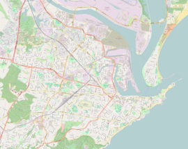
New Lambton is a suburb located in the city of Newcastle, Australia. It's part of the Hunter Region in New South Wales. This area is about 6 kilometers (3.7 miles) west of Newcastle's main city center.
New Lambton has two shopping areas, several schools, and other useful places for its residents. In 2016, about 10,000 people lived here. It started as a town focused on coal mining. Later, it became its own local government area before joining the larger city of Newcastle. Today, New Lambton is mostly a place where people live. It also has a large nature reserve and a major sports center.
Contents
Exploring New Lambton's Geography
New Lambton has an interesting shape and covers about 5.5 square kilometers (2.1 square miles). Most of the suburb is residential, meaning it's where people live. However, a big part of its southwestern side is taken up by Blackbutt Reserve. This is a large nature area, about 182 hectares (450 acres), mostly made up of natural bushland.
The eastern part of New Lambton is mostly flat and close to sea level. But as you move west, the land rises. The highest points are in Blackbutt Reserve, reaching about 90 meters (295 feet) above sea level.
A Look Back at New Lambton's History
The Awabakal and Worimi people were the first to live in the Newcastle area, including what is now New Lambton.
How New Lambton Began
New Lambton started as a town built around coal mining. The New Lambton Colliery (a coal mine) was located just east of the suburb, in what is now Adamstown.
On January 8, 1889, New Lambton officially became its own municipality. This meant it had its own local government and covered an area of about 2,560 acres (10.4 square kilometers).
New Lambton in 1901
By 1901, New Lambton had a population of 1,464 people. The local council was led by Mayor George Errington. The council also had a Town Clerk, Henry J. Noble, and several Aldermen who helped manage the town.
The town earned a lot of money from the Lambton Colliery. This big coal mine was managed by the Croudace brothers. Even though the mine was closer to Lambton, it was part of the New Lambton municipality. Today, a main street called Croudace Street is named after them.
At this time, New Lambton was doing well. It had no debt and boasted a telegraph office, council chambers, a Mechanics Institute (a place for learning and reading), a reading room, a fire brigade, and a public school. These were all signs of a growing and modern town.
Later Developments
In 1938, a new law created the "City of Greater Newcastle." This law combined eleven smaller municipalities, including New Lambton, into one larger local government area.
During World War II, New Lambton Public School was used by the government as a military headquarters. It was called No. 2 Fighter Sector Headquarters. Because of this important role, the school was given special permission in 1995 to fly the Royal Australian Air Force Ensign. It is the only school in Australia allowed to do this.
New Lambton also used to have a beautiful art deco movie theater called The Savoy. This building is now used as the New Lambton Community Centre.
Getting Around New Lambton
New Lambton is surrounded by or has several important roads that help people travel. Lookout Road and Croudace Road are on the western side of the suburb. To the east, Lambton Road makes it easy to get to Newcastle's city center. In the south, Carnley Avenue and Northcott Drive connect New Lambton to suburbs in the City of Lake Macquarie.
The southeastern part of New Lambton is next to the Main North Line. The suburb is served by Adamstown railway station, making it easy to travel by train.
Discovering Blackbutt Reserve
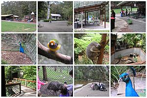
The entire southwestern part of New Lambton is home to Blackbutt Reserve. The main entrances to the reserve are on Carnley Avenue and Freyberg Street. These are about 8.8 kilometers (5.5 miles) by road from Newcastle's city center.
Blackbutt Reserve covers 182 hectares (450 acres) and is mostly urban bushland. It has nature trails for walking, exhibits where you can see wildlife, playgrounds for children, and other fun facilities. The Newcastle City Council manages the reserve. It features over 16 kilometers (10 miles) of paths that wind through open rainforest.
There are four main areas in the reserve perfect for picnics and recreation, each with its own entry point:
- Black Duck Picnic Area, found off Carnley Avenue.
- Richley Reserve Picnic Area, located off Freyberg Street. This spot used to be the site of the Buchanan Borehole Colliery.
- Dead Tree Picnic Area.
- Lily Pond Picnic Area, near the corner of Queens Road and Mahogany Drive.
Sports and Recreation in New Lambton
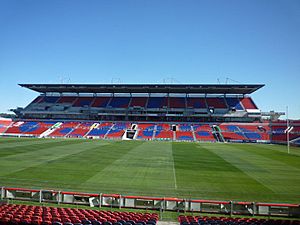
New Lambton has several parks where different sports are played. In the northeastern part of the suburb, you'll find the Newcastle International Sports Centre. This is a major venue used by the National Rugby League team, the Newcastle Knights, and the A-League soccer team, the Newcastle Jets.
New Lambton is also home to the New Lambton Football Club. This is the largest soccer club in Northern NSW based on its number of members. They play their games at Alder Park and Novocastrian Park. The New Lambton Football Club started way back in 1896 when Scottish miners first played soccer. It became an official club in 1917 after soldiers returned home from World War I and went back to working in the mines. The Western Suburbs Rugby League and Cricket Club also calls Harker Oval its home ground.
Learning in New Lambton
New Lambton has several schools for students. New Lambton Public School is a government primary school for both boys and girls, located on Regent Street. Another government primary school, New Lambton South Public School, is on 45 St James Street. There is also a Catholic primary school for boys and girls called St Therese's Primary, located on Burke Street.
 | Sharif Bey |
 | Hale Woodruff |
 | Richmond Barthé |
 | Purvis Young |


