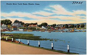
Niantic River facts for kids
Quick facts for kids Niantic River |
|
|---|---|
| Country | United States |
| State | Connecticut |
| Counties | New London |
| Physical characteristics | |
| Main source | Banning Cove East Lyme, New London County, Connecticut, United States 41°39′39″N 72°06′37″W / 41.66083°N 72.11028°W |
| River mouth | Long Island Sound East Lyme, New London County, Connecticut, United States 41°32′22″N 72°18′12″W / 41.53944°N 72.30333°W |
The Niantic River is a special waterway in eastern Connecticut, United States. It's mostly a tidal river, which means its water level changes a lot with the ocean's tides. This river helps separate two towns: East Lyme and Waterford. It's about 5.2 miles (8.4 km) (or 8.4 kilometers) long.
The Niantic River is an important part of the local environment. Many smaller streams, like Oil Mill Brook and Stony Brook, flow into it. The Niantic River itself then flows into the Long Island Sound, which is part of the Atlantic Ocean. The distance from Banning Cove to the Niantic River Bridge is about 3.4 miles.
Contents
History of the Niantic River
Long before any European settlers arrived, people lived along the Niantic River. About 12,000 years ago, the Western Nehantic people made their homes here.
How the Nehantic People Lived
The Nehantic people survived by using the river's natural gifts. They gathered shellfish, caught fish, and found other marine life. The river was a very important source of food for them.
Wildlife in the Niantic River
The Niantic River is home to many different kinds of animals. It's a great place to see various birds and fish.
Birds of the River
You can spot many beautiful birds along the Niantic River. These include majestic bald eagles, ospreys, egrets, herons, and cormorants. They often come to the river to hunt for fish.
Fish and Shellfish
The river has several types of fish that are popular for catching. These include flounder, hickory shad, and striped bass. One of the river's most famous shellfish, the scallop, has unfortunately become harder to find.
Tides and Water Levels
The Niantic River has a big difference between its high tide and low tide. At certain spots, when the tide is low, the water level can actually drop below sea level. This shows how much the ocean's tides affect the river.
River Crossings
The Niantic River has several important crossings that connect the towns of East Lyme and Waterford. These crossings allow cars and trains to pass over the river.
| Town | Carrying |
|---|---|
| East Lyme/ | |
 | William M. Jackson |
 | Juan E. Gilbert |
 | Neil deGrasse Tyson |


