
Waterford, Connecticut facts for kids
Quick facts for kids
Waterford, Connecticut
|
||
|---|---|---|
| Town of Waterford | ||

A house in Quaker Hill
|
||
|
||
 New London County and Connecticut New London County and Connecticut Southeastern Connecticut Planning Region and Connecticut Southeastern Connecticut Planning Region and Connecticut |
||
| Country | ||
| U.S. state | ||
| County | New London | |
| Region | Southeastern CT | |
| Incorporated | 1801 | |
| Government | ||
| • Type | Representative town meeting | |
| Area | ||
| • Total | 44.6 sq mi (115.4 km2) | |
| • Land | 32.8 sq mi (84.9 km2) | |
| • Water | 11.8 sq mi (30.5 km2) | |
| Elevation | 46 ft (14 m) | |
| Population
(2020)
|
||
| • Total | 19,571 | |
| • Density | 439.24/sq mi (169.59/km2) | |
| Time zone | UTC−5 (Eastern) | |
| • Summer (DST) | UTC−4 (Eastern) | |
| ZIP Codes |
06375, 06385
|
|
| Area code(s) | 860/959 | |
| FIPS code | 09-80280 | |
| GNIS feature ID | 0213526 | |
| Interstates | ||
| List of auxiliary Interstate Highways | ||
| U.S. Highways | ||
| State Routes | ||

Waterford is a town in New London County, Connecticut, United States. It is named after Waterford, Ireland. The town is part of the Southeastern Connecticut Planning Region. In 2020, about 19,571 people lived there. A smaller part of the town, called the town center, is also a census-designated place (CDP). In 2020, about 3,074 people lived in the CDP.
Contents
- Exploring Waterford's Location
- Waterford's Past: A Look Back
- Waterford's Population Over Time
- Learning in Waterford: Schools and Education
- Waterford's Economy: How People Work
- Fun Things to Do in Waterford
- Keeping Waterford Safe: Emergency Services
- Famous People from Waterford
- Images for kids
- See also
Exploring Waterford's Location
Waterford is a town in Connecticut. It covers about 115.4 square kilometers (44.6 square miles). Most of this area, about 84.9 square kilometers (32.8 square miles), is land. The rest, about 30.5 square kilometers (11.8 square miles), is water. The town center itself is all land, about 4.9 square kilometers (1.9 square miles). The Niantic River forms the western border of Waterford.
Key Areas in Waterford
Waterford has several important communities and neighborhoods. These include:
- Waterford (the town center)
- Graniteville
- Jordan
- Millstone
- Morningside Park
- Quaker Hill
Other smaller areas you might find are Cohanzie Hill, East Neck, Fog Plain, and Great Neck.
Waterford's Past: A Look Back
Waterford has a long and interesting history. It started as a farming community and grew over time.
How Waterford Began
The first English settlers arrived in the New London and Waterford area in 1637. This land was then known as West Farms. One of the first settlers was John Winthrop Jr. Waterford got its name because it is located between two rivers. Early residents lived in simple homes called wigwams. Later, they built 38 houses near the Great Neck area. Winthrop Jr. received a lot of land, including Millstone Point. Dams, mills, and ponds were built in these areas.
Over time, more people moved to Waterford. They came from places like Wales, Italy, Russia, Ireland, and Scotland. Waterford officially separated from New London on October 8, 1801. This happened after local farmers asked for their own town. The first town meeting was held in November 1801. At this meeting, people chose town officials. These included tax collectors, surveyors, and a first selectman. Only the first selectman was paid back then.
Waterford in the 1800s
In the 19th century, Waterford was mostly a farming town. Many people raised sheep. Waterford was also famous for its granite industry. This industry lasted from the late 1800s until the 1930s. The Graniteville area in Waterford is named after this industry. Even the area where Crystal Mall is today used to have granite quarries.
Waterford's granite was used in many building projects. It helped build roads, the foundation for Fort Sumter, and even the Statue of Liberty. But over time, concrete became more popular than granite. This caused the granite industry to shrink until it mostly disappeared by the 1930s.
Waterford in the 1900s
In the 20th century, dairy farms replaced sheep farms in Waterford. Between 1920 and 1960, there were about 100 dairy farms. These farms had many cattle. In 1946, Waterford got its official town seal. A famous cartoonist named Martin Branner designed it. He also created the comic strip, Winnie Winkle.
After World War II, Waterford grew very quickly. Many new roads and buildings were constructed. The town's population also increased by 10,000 people since 1946. In 1957, Waterford got its first stop light. The first shopping center was built starting in 1960.
Waterford's Population Over Time
| Historical population | |||
|---|---|---|---|
| Census | Pop. | %± | |
| 1820 | 2,239 | — | |
| 1850 | 2,259 | — | |
| 1860 | 2,555 | 13.1% | |
| 1870 | 2,482 | −2.9% | |
| 1880 | 2,701 | 8.8% | |
| 1890 | 2,661 | −1.5% | |
| 1900 | 2,904 | 9.1% | |
| 1910 | 3,097 | 6.6% | |
| 1920 | 3,935 | 27.1% | |
| 1930 | 4,742 | 20.5% | |
| 1940 | 6,594 | 39.1% | |
| 1950 | 9,100 | 38.0% | |
| 1960 | 15,391 | 69.1% | |
| 1970 | 17,227 | 11.9% | |
| 1980 | 17,843 | 3.6% | |
| 1990 | 17,930 | 0.5% | |
| 2000 | 19,152 | 6.8% | |
| 2010 | 19,517 | 1.9% | |
| 2020 | 19,571 | 0.3% | |
| U.S. Decennial Census | |||
Waterford has a mix of rural and city living. In 2010, there were 19,517 people living in the town. These people lived in 8,005 households. About 5,335 of these were families.
The town's population density was about 584.7 people per square mile. Most people in Waterford are White (89.4%). There are also African American (2.5%), Asian (3.7%), and other racial groups. About 4.7% of the population is Hispanic or Latino.
In 2010, about 26.4% of households had children under 18. The average household had 2.38 people. The average family had 2.91 people. The median age in Waterford was 46.1 years old.
Learning in Waterford: Schools and Education
Waterford has a long history of education. The first elementary schools appeared in 1915. Quaker Hill School was built then. Before that, in 1725, a piece of land was set aside for Quaker Hill. The town was divided into three school districts. Each district would later be split into even more smaller districts.
A second schoolhouse was built in 1858. Cohanzie School was built in 1923. It replaced four older schools. Cohanzie School closed in 2009. There have been talks about turning the building into a home for senior citizens.
The Historic Jordan Schoolhouse
The Jordan Schoolhouse is the oldest known school in Waterford. It was first mentioned in 1737. It was located on the Jordan Green. Farmers wanted their children to learn reading, writing, math, and religion. The Jordan School also taught good manners and obedience.
Private lessons were not common in Waterford. But they became available in the 19th century for those who could pay. The Jordan School taught its last class in 1979. Today, the Jordan School is a museum. Visitors can learn about its history.
Waterford's Economy: How People Work
Waterford's economy mainly focuses on retail stores. You can find many shopping centers and the Crystal Mall here. There are also several local restaurants and delis.
Waterford is home to JayPro Sports. This company makes sports equipment for baseball, basketball, and tennis. It is also home to Dominion's Millstone Nuclear Power Plant. This plant has three reactors. The first one was built between 1966 and 1970. One reactor is no longer working. But the other two still provide power to many towns in New England.
Main Employers in Waterford
Here are some of the biggest employers in Waterford, based on a 2023 report:
| # | Employer | # of Employees |
|---|---|---|
| 1 | Dominion Nuclear Plant | 1,650 |
| 2 | Town of Waterford | 595 |
| 3 | Waterford Hotel Group | 568 |
| 4 | Walmart | 497 |
| 5 | Sonalysts Inc. | 486 |
| 6 | Home Depot | 200 |
| 7 | Bayview Healthcare Center | 200 |
| 8 | Lowes | 119 |
| 9 | BJ's Wholesale Club | 112 |
| 10 | Coca-Cola | 120 |
Fun Things to Do in Waterford
Waterford has many places to visit and fun activities.
- Mago Point is an area with many marine businesses.
- The Connecticut College Arboretum is a large garden and nature area. It covers about 750 acres. Part of it is in Quaker Hill, a neighborhood of Waterford.
- The Eugene O'Neill Theater Center is in Waterford. The Intentional Theatre is also located here.
- Waterford Beach is a great place to relax by the water.
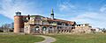
- Harkness Memorial State Park offers beautiful views of Long Island Sound. The park has a former mansion and gardens. It belonged to Edward Harkness, who bought the property in 1907. Next to Harkness Park is Camp Harkness for the Handicapped. This is a summer camp for children and adults with disabilities.
- The Waterford Speedbowl is a racetrack. It opened in 1951 and is still running today.
- In 2009, the game show Deal or No Deal was filmed at Sonalyst Studios in Waterford.
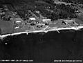
- The Seaside Sanatorium is a historic property. It is a 36-acre shoreline property. Architect Cass Gilbert designed it. It opened in 1934 to treat patients with tuberculosis. Later, it became a hospital for older people. From 1961 to 1996, it helped people with developmental disabilities.
Keeping Waterford Safe: Emergency Services
Waterford has dedicated teams to keep its residents safe.
Waterford Police Department
The Waterford Police Department has 47 active officers. Chief Marc Balestracci leads the department. There is also a Board of Police Commissioners. The department includes Lieutenants, Sergeants, and Patrol Officers. They also have K-9 Officers, Detectives, and School Resource Officers.
Waterford Fire Service
The town of Waterford is protected by a fire service. It includes both volunteers and paid firefighters. There are five fire companies located around the town.
Waterford Ambulance Service
Waterford Ambulance provides ambulance services for the town. It is a non-profit service. They offer emergency medical care to residents and visitors. They also provide ambulance transportation. They follow all state and federal laws.
Famous People from Waterford
- Veronica Ballestrini – a country music singer and songwriter.
- Malia DelaCruz – an Indie Rock musician known as CIAO MALZ.
- Billy Gardner – a baseball player, manager, and coach.
- Sara Juli – a modern dancer and choreographer.
- Jan Merrill – an Olympic Runner. She was the first American woman to run in the mile finals.
Images for kids
-
Seaside Sanatorium, 1937
-

The Eugene O'Neill Theater Center, opened in 1964.
-
The Seaside Sanitorium, built in 1934.
.jpg)

See also
 In Spanish: Waterford (Connecticut) para niños
