
East Lyme, Connecticut facts for kids
Quick facts for kids
East Lyme, Connecticut
|
|||
|---|---|---|---|
| Town of East Lyme | |||

Salt marsh in East Lyme
|
|||
|
|||
 New London County and Connecticut New London County and Connecticut Southeastern Connecticut Planning Region and Connecticut Southeastern Connecticut Planning Region and Connecticut |
|||
| Country | |||
| U.S. state | |||
| County | New London | ||
| Region | Southeastern CT | ||
| Incorporated | 1839 | ||
| Government | |||
| • Type | Selectman-town meeting | ||
| Area | |||
| • Total | 42.0 sq mi (108.8 km2) | ||
| • Land | 34.0 sq mi (88.1 km2) | ||
| • Water | 7.9 sq mi (20.6 km2) | ||
| Elevation | 210 ft (64 m) | ||
| Population
(2020)
|
|||
| • Total | 18,693 | ||
| • Density | 445.1/sq mi (171.81/km2) | ||
| Time zone | UTC-5 (Eastern) | ||
| • Summer (DST) | UTC-4 (Eastern) | ||
| ZIP Codes |
06333, 06357
|
||
| Area code(s) | 860/959 | ||
| FIPS code | 09-23400 | ||
| GNIS feature ID | 0213426 | ||


East Lyme is a town located in New London County, Connecticut, in the United States. It is part of the Southeastern Connecticut Planning Region. In 2020, about 18,693 people lived here. The town includes two main villages: Niantic and Flanders.
Contents
Exploring East Lyme's Geography
East Lyme is in southern New London County. It is west of Waterford and Montville. To its east are Lyme and Old Lyme. South of East Lyme is the Long Island Sound, a large body of water. The town covers about 42 square miles (108.8 square kilometers). About 34 square miles (88.1 square kilometers) is land, and 7.9 square miles (20.6 square kilometers) is water.
Villages of East Lyme
East Lyme has two main villages: Flanders and Niantic. Many people mistakenly call the whole town "Niantic." This is because Niantic is the popular "beach side" of town. It attracts many tourists in the summer. Niantic's population can double during the beach season. It is much busier than Flanders. Flanders is known for its apple orchards, the town's high school, and forests.
Discover Niantic Village
The village of Niantic gets its name from the Niantic or Nehantic Native American tribes. Their lands once stretched from Rhode Island to the Connecticut River. Before the first settlers arrived, the Pequots had taken some of their land.
Niantic's main industries are sportfishing and marinas. Summer tourism and restaurants are also very important. Many seafood restaurants and hotels serve visitors to the town's beaches. They also serve people visiting nearby casinos like Foxwoods and Mohegan Sun. Rocky Neck State Park offers camping, swimming, and picnic areas.
The Niantic Bay Boardwalk is a 1-mile (1.6 km) long path. It runs next to the Amtrak railroad tracks. It goes from the Niantic River to Hole-in-the-Wall municipal beach. The boardwalk first opened in 2005. It was closed for a while due to railroad bridge construction and damage from Hurricane Irene. It fully reopened in March 2016.
The Children's Museum of Southeastern Connecticut is in Niantic. It is located in East Lyme's original public library building. This museum is mostly for children aged infant to ten years old. The current public library is on Society Road, away from Niantic.
Niantic includes several beach communities. These are Attawan Beach, Black Point, Crescent Beach, Giants Neck Beach, Giants Neck Heights, Oak Grove Beach, Old Black Point, Pine Grove, and Saunder's Point.
Exploring Flanders Village
The village of Flanders was originally a farming area. It got its name from woolen mills, similar to those in Flanders, Belgium. The center of Flanders is at Flanders Four Corners. This is where Chesterfield Road (Route 161) meets Boston Post Road (Route 1). Here you can find many small shops and businesses. East Lyme High School, Flanders Elementary School, and the Board of Education are also here.
Flanders was once the main social center of East Lyme. It had many 18th-century homes, shops, and inns along the Boston Post Road. But Niantic grew more important as commercial fishing and the Shore Line Railway developed. Many old Flanders homes were lost when I-95 was built in the 1950s. General George Washington even stopped at the old Caulkins Tavern in Flanders in 1776.
Other Small Communities
Golden Spur is a community at the start of the Niantic River. It was once called "Head of the River." In the 1700s, there was a shipyard here. By the early 1900s, it had an amusement park. This park was reached by a trolley and operated until 1924.
East Lyme's Landscape
East Lyme has rolling hills and green valleys. These were shaped by glaciers during the last Ice Age. Hills in the eastern and central parts of town rise to 250 to 350 feet (76 to 107 meters) above sea level. The highest point in town is an unnamed hill. It is 500 feet (152 meters) high and is in Nehantic State Forest. East Lyme is very beautiful in the summer when the trees are in bloom. On its east and south sides, the town meets the ocean. The Niantic River flows into Niantic Bay, which is part of Long Island Sound.
Population and Community Life
In 2000, East Lyme had 18,118 people living there. The population density was about 532 people per square mile (205 per square kilometer). The town had 6,308 households. Most people (87.29%) were White. About 6.37% were African American, and 2.82% were Asian. About 4.59% of the population was Hispanic or Latino.
The average household had 2.50 people, and the average family had 2.96 people. About 21.9% of the population was under 18 years old. The median age was 39 years. This means half the people were younger than 39, and half were older.
The median income for a household in East Lyme was $66,539. For families, it was $74,430. Only a small number of families (1.7%) and people (2.9%) lived below the poverty line.
Schools in East Lyme
The public schools in East Lyme are run by the East Lyme School District.
The district has:
- One high school: East Lyme High School
- One middle school: East Lyme Middle School (for grades 5–8)
- Three elementary schools:
- Flanders Elementary School (Pre-K–4)
- Lillie B. Haynes Elementary School (Pre-K–4)
- Niantic Center School (K–4)
East Lyme High School has been recognized as one of the top high schools in the country by Newsweek and U.S. News & World Report. In 2017, it received a National Blue Ribbon Distinction from the U.S. Department of Education. This award is for schools that show high achievement or help close learning gaps.
The high school also has the East Lyme Aquatic & Fitness Center. This center has a large swimming pool and a fitness area. It is used by school teams and is also open to the public. Students from the nearby town of Salem also attend East Lyme High School.
East Lyme Middle School has also won many awards. It was a National Blue Ribbon School in 1999–2000. It was also named the Connecticut Association of Schools 2013–2014 School of the Year. The middle school uses a "kiva" team program. Students are grouped into teams with different teachers for science, language arts, social studies, and math.
East Lyme's Rich History

The Thomas Lee House, built around 1660, is the oldest house in Connecticut that is still in its original condition. It is located near Rocky Neck State Park. The Little Boston Schoolhouse, a one-room school, was moved to this site. East Lyme has six homes built in 1699 or earlier. The Old Stone Church Burial Ground, from 1719, is also here.
The area was first home to the Nehantic people. They had villages in places like Indian Woods and Black Point. The tribe became allies with the colonists in a war against the Pequot people in 1636.
East Lyme, which was once part of Lyme, had several taverns. These taverns were places where travelers could stop. General George Washington visited Calkins Tavern in 1776. At least 45 veterans from the American Revolutionary War are buried in East Lyme.
Historic Places to Visit
- Morton Freeman Plant Hunting Lodge – built in 1908.
- Samuel Smith House – built in 1685.
- Smith-Harris House – built in 1845.
- Thomas Lee House – built around 1664, one of the oldest houses in Connecticut.
- William Gorton Farm – a historic farm.
Media and Communication
Library Services
The first library in East Lyme started in 1888. It was called the Niantic Library and Reading Room Association. In 1897, it became "The Niantic Public Library Association." The library moved several times before a permanent building was built on Main Street in 1920. In 1990, the library moved into the new Community Center/Library complex, where it is today.
Local Radio and Movies
FM radio station WNLC is based in East Lyme.
East Lyme has also been a filming location for movies. Parts of the TV movie Disaster on the Coastliner were filmed here in 1979. In 2016, the Lifetime thriller Hunter's Cove (later renamed Stalker's Prey) was filmed in East Lyme.
East Lyme's Economy
In 2009, about 42.2% of East Lyme's businesses were in the service industry. This includes retail, food services, and transportation. The second largest industry was trade, with 23.1% of businesses. Construction and mining made up 12.5% of the town's businesses.
The biggest employer in East Lyme is the state of Connecticut's Department of Corrections. They run a women's prison called York Correctional Institution in the western part of town. Another prison for men, Gates Correctional Institute, closed in 2011.
Beaches of East Lyme

East Lyme is known for its beautiful beaches.
Public Beaches for Everyone
- Rocky Neck State Park – This state park has two beaches: East Beach and West Beach.
- McCook Park Beach – Also known as "McCook's," this beach is next to McCook Point Park. The town bought it in 1953. It is open to the public for a fee from Memorial Day to Labor Day. It is free at other times.
- Hole-in-the-Wall Beach – This beach is about 5 acres (2 hectares) in size. It is next to McCook Point Park. You can enter it through a walkway under the railroad tracks. It is open to the public for a fee during summer. This beach also connects to the Niantic Beach Boardwalk.
- Railroad Beach – This beach is at the eastern end of the Niantic Bay Overlook. It is near the Niantic Railroad Drawbridge. You can reach it from the Niantic Bay Overlook or Cini Park.
Private Beaches for Residents
Some beaches in East Lyme are private. This means they are only for homeowners in specific areas or members of certain associations. These include:
- Crescent Beach
- Oak Grove Beach
- Black Point Beach
- Old Black Point Beach
- Attawan Beach
- Giants Neck Heights Beach
- Pine Grove
- Oswegatchie Hills Club (for families in Saunders Point)
Famous People from East Lyme
Many interesting people have connections to East Lyme:
- Tom Danielson (born 1978) – A professional cyclist who finished 8th in the 2011 Tour de France.
- John Ellis (born 1948) – A former Major League Baseball player for the New York Yankees. He also founded the CT Sports Foundation against Cancer.
- Pete Walker (born 1969) – A former Major League Baseball player and current Pitching Coach for the Toronto Blue Jays.
- John McDonald (born 1974) – A former Major League Baseball player and current Infield Coach for the Cleveland Indians.
- Rajai Davis (born 1980) – A Major League Baseball player who hit a game-tying home run in Game 7 of the 2016 World Series.
- Charles Drake (1917–1994) – An actor who appeared in over 80 films.
- Otto Graham (1921–2003) – A Hall of Fame professional football player.
- James Stevenson (1929–2017) – An illustrator and author of over 100 children's books. His cartoons often appeared in The New Yorker.
- Ed Toth – The current drummer for The Doobie Brothers.
- Jeremy Powers – A former professional racing cyclist from East Lyme. He has the most wins by an American male cyclo-cross rider.
- Vladimir Peter Tytla (1904–1968) – One of the original Disney animators.
Places of Worship
East Lyme has many different churches and places of worship:
- Christ Lutheran Church (Lutheran)
- Lighthouse Assembly of God (Assemblies of God)
- Flanders Baptist Church (Baptist)
- Saint Matthias Church (Roman Catholic)
- Miracle Temple Church (Non-denominational)
- Niantic Community Church (United Methodist Church & United Church of Christ)
- Saint Agnes Church (Roman Catholic)
- Niantic Baptist Church (Baptist)
- Saint John's Episcopal Church (Episcopal)
Cemeteries

East Lyme has several cemeteries:
- East Lyme Cemetery, on Boston Post Road
- Stone Church, at the intersection of Society and Riverview roads, Niantic
- Union Cemetery, on East Pattagansett Road, Niantic
Images for kids
-
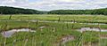
A beautiful salt marsh in East Lyme.
-
The official flag of East Lyme.
-

The official seal of East Lyme.
-
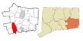
Map showing East Lyme's location in New London County.
-
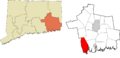
Map showing East Lyme's location in Southeastern Connecticut.
-
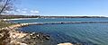
View of the Rocky Neck State Park Jetty, beach and the Giants Neck area shoreline in the Niantic section of East Lyme, Connecticut.
-
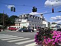
The Morton House Hotel in the village of Niantic has been in continuous operation for more than 100 years.
-
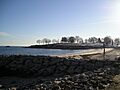
Hole-in-the-Wall Beach in Niantic, looking west towards McCook Point.
-
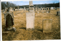
East Lyme Cemetery.


See also
 In Spanish: East Lyme para niños
