
Old Lyme, Connecticut facts for kids
Quick facts for kids
Old Lyme, Connecticut
|
||
|---|---|---|
| Town of Old Lyme | ||

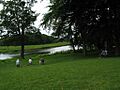
View of the Connecticut River in Old Lyme near its mouth at Long Island Sound
|
||
|
||
 New London County and Connecticut New London County and Connecticut Lower Connecticut River Valley Planning Region and Connecticut Lower Connecticut River Valley Planning Region and Connecticut |
||
| Country | ||
| U.S. state | ||
| County | New London | |
| Region | Lower CT River Valley | |
| Incorporated | 1855 | |
| Government | ||
| • Type | Selectman-town meeting | |
| Area | ||
| • Total | 28.8 sq mi (74.6 km2) | |
| • Land | 23.1 sq mi (59.8 km2) | |
| • Water | 5.7 sq mi (14.8 km2) | |
| Elevation | 20 ft (6 m) | |
| Population
(2020)
|
||
| • Total | 7,628 | |
| • Density | 264.9/sq mi (102.25/km2) | |
| Time zone | UTC-5 (Eastern) | |
| • Summer (DST) | UTC-4 (Eastern) | |
| ZIP code |
06371
|
|
| Area code(s) | 860/959 | |
| FIPS code | 09-57040 | |
| GNIS feature ID | 0213483 | |

Old Lyme is a beautiful coastal town in New London County, Connecticut, United States. It's located right where the Connecticut River meets the Long Island Sound. To its east is the town of East Lyme, and to its north is the town of Lyme.
The town's main street, Lyme Street, is a special historic area. It has many old homes that used to belong to sea captains. Old Lyme is also famous for its lively art scene. Important art places here include the Florence Griswold Museum, the Lyme Art Association, and the Lyme Academy of Fine Arts.
Old Lyme is home to several fun beach communities that are popular in summer, like Point O' Woods, Hawk's Nest, and Miami Beach. The town got its name from Lyme Regis, a town in England.
Old Lyme includes several smaller villages, such as Black Hall, Laysville, Soundview, and South Lyme. In 2020, about 7,628 people lived in the town.
Contents
Old Lyme: A Coastal Town's Story

Old Lyme is a town with about 7,600 people who live there all year. In the summer, thousands more visitors come to enjoy the seaside. It sits on the east side of the Connecticut River, where it flows into Long Island Sound. Across the river is the town of Old Saybrook. You can see many old-style American homes from the Colonial and Federal periods throughout the town.
The area was first settled as part of Saybrook (now Deep River). On February 13, 1665, the town of Lyme was created from Saybrook. Later, in 1855, South Lyme was formed from Lyme. It was renamed Old Lyme in 1857 because it was the oldest part of the original Lyme settlement.
Old Lyme covers about 27 square miles (70 square kilometers) of shoreline, marshlands, wetlands, and forests. Its neighbor to the north is Lyme, and to the east is East Lyme. The name "Lyme" comes from Lyme Regis, a small port town in England where some of the first settlers came from in the 1600s. The historic Old Lyme Cemetery is where many of these early settlers are buried. The Duck River flows through the cemetery and into the Connecticut River.
Lyme Disease: How It Got Its Name
Lyme disease was named after the town of Lyme and Old Lyme. This happened in 1975 after a strange sickness appeared. It looked like a type of arthritis in children living in these towns. Scientists then discovered it was a new disease and named it after the area where it was found.
Old Lyme Art Colony: A Creative Hub

The Florence Griswold House in Old Lyme was home to a famous art colony in the early 1900s. Many important American Impressionist painters lived and worked there. Some of these artists included Childe Hassam, Edward Charles Volkert, Willard Metcalf, Wilson Irvine, and Henry Ward Ranger. These artists made Old Lyme a lively place for art, and that tradition continues today.
The Griswold House was later turned into an art museum called the Florence Griswold Museum. Locals often call it "Flo Gris." Many American Impressionist paintings show scenes from the Griswold House and the surrounding area. These paintings, along with other works and personal items from the artists, are displayed in the museum. The Old Lyme Congregational Church building is also famous because many artists, especially Childe Hassam, painted it.
Historic Places in Old Lyme

Several places in Old Lyme are listed on the National Register of Historic Places. This means they are important historical sites. Some of them include:
- Bennett Rockshelter (added July 31, 1987)
- Florence Griswold House and Museum – 96 Lyme St. (added May 19, 1993)
- Lieutenant River III Site (added August 31, 1987)
- Lieutenant River IV Site (added August 31, 1987)
- Lieutenant River No. 2 (added August 31, 1987)
- Natcon Site (added August 31, 1987)
- Old Lyme Historic District – This includes Lyme Street and parts of Old Boston Post Road (added November 14, 1971)
- Peck Tavern – 1 Sill Lane (added May 12, 1982)
- Springbank – 69 Neck Road (added September 17, 2001)
Geography and Weather

Old Lyme has a total area of about 28.8 square miles (74.6 square kilometers). About 5.7 square miles (14.8 square kilometers) of this is water. The southern part of Old Lyme is mostly flat with marshy areas. The northern parts of the town have rocky hills.
Old Lyme has a mild climate. Summers are warm, with temperatures often in the 80s °F (27-32 °C) and sometimes reaching the 90s °F (32-37 °C). Winters are cool, with highs in the upper 30s to low 40s °F (3-7 °C). The town gets about 40 inches (100 cm) of rain each year. It also gets about 28 inches (71 cm) of snow on average in winter, but the snow usually doesn't stay long.
Main Communities in Old Lyme
Old Lyme is made up of several smaller communities:
- Black Hall
- Laysville
- Lyme Station
- Old Lyme Center
- Sound View
- South Lyme
- Edge Lea
- Hatchetts Point
- Point O'Woods
Other smaller areas and natural spots include Four Mile River, Griswold Point, Hawk's Nest Beach, Miami Beach, Mile Creek, Rogers Lake, and White Sand Beach.
Rogers Lake: Home to a Legend
Rogers Lake is a lake partly in Old Lyme and partly in the town of Lyme. It was formed by a dam. The lake covers about 265 acres (1.07 square kilometers). Mill Brook, Grassy Hill Brook, and Broad Swamp Brook flow into the lake.
There are five small islands on Rogers Lake. The biggest island even has a small cottage on it. Each year, the lake is stocked with brook and rainbow trout for fishing. A street along the north side of the lake is called Blood Street. It gave its name to the town's rowing team, the Blood Street Sculls.
Roger: The Rogers Lake Monster
Roger is the name of a rumored lake monster said to live in Rogers Lake. Like the famous Loch Ness Monster or Lake Champlain's Champ, some people believe Roger is real, while others think it's just a story. Some even wonder if Roger could be related to the plesiosaur, an ancient water reptile.
Even though there's no scientific proof, over 200 sightings of Roger have been reported! The legend of Roger is a fun story that helps bring tourists to the Old Lyme and Lyme areas. Native American tribes in Connecticut used to call a creature in the lake "Caca-togo."
The first recorded sighting of Roger was in 1878 by the famous local artist Florence Griswold. According to a report, Ms. Griswold was painting by the lake when she saw a large, long-necked, gray, dinosaur-like creature rise 20 feet (6 meters) out of the water before quickly disappearing. She told her family she wasn't scared, just very curious. For years after, Florence Griswold would paint Roger into the backgrounds of some of her artworks. A professor once joked that if Picasso had a "red period," then Griswold had her "Lake Monster period."
Population of Old Lyme
| Historical population | |||
|---|---|---|---|
| Census | Pop. | %± | |
| 1860 | 1,304 | — | |
| 1870 | 1,362 | 4.4% | |
| 1880 | 1,387 | 1.8% | |
| 1890 | 1,319 | −4.9% | |
| 1900 | 1,180 | −10.5% | |
| 1910 | 1,181 | 0.1% | |
| 1920 | 946 | −19.9% | |
| 1930 | 1,313 | 38.8% | |
| 1940 | 1,702 | 29.6% | |
| 1950 | 2,141 | 25.8% | |
| 1960 | 3,068 | 43.3% | |
| 1970 | 4,964 | 61.8% | |
| 1980 | 6,159 | 24.1% | |
| 1990 | 6,535 | 6.1% | |
| 2000 | 7,406 | 13.3% | |
| 2010 | 7,603 | 2.7% | |
| 2020 | 7,628 | 0.3% | |
| U.S. Decennial Census | |||

In 2010, about 7,603 people lived in Old Lyme. There were 2,958 households and 2,153 families. About 30.2% of households had children under 18. The average household had 2.50 people.
The median age in Old Lyme was 43 years old. This means half the people were older than 43 and half were younger. About 24% of the population was under 18.

The median income for a household in Old Lyme was $68,386. For a family, it was $75,779. This shows how much money households and families earned on average. About 3.4% of the population lived below the poverty line.
Schools in Old Lyme
Children from Old Lyme and Lyme attend schools in Regional District 18. In the 2011–2012 school year, about 1,450 students were enrolled. The schools are:
- Lyme Consolidated School (Pre-kindergarten to Grade 5)
- Mile Creek School (Kindergarten to Grade 5)
- Center School (Pre-kindergarten)
- Lyme-Old Lyme Middle School (Grades 6 to 8)
- Lyme-Old Lyme High School (Grades 9 to 12)
The school district has a good student-to-teacher ratio, with about 13 students for every teacher. The district's girls' soccer and boys' basketball teams won championships in 2010–2011. Some students from Old Lyme also go to private schools nearby.
Colleges in Old Lyme

The Lyme Academy College of Fine Arts was founded in 1976 by Elisabeth Gordon Chandler. It teaches figurative art like sculpture, drawing, illustration, and painting. The college offers a bachelor's degree in fine arts. It also has programs for students who already have a degree or want a certificate. The academy is known for teaching traditional art techniques, focusing on studying nature and the human figure. Many people in the art world believe this college has helped bring back traditional art styles.
Transportation in Old Lyme
The Estuary Transit District provides public transportation in Old Lyme and nearby towns. Their 9 Town Transit service connects to the Old Saybrook Train Station, where you can catch Amtrak and Shore Line East trains. It also connects to the New London Transportation Center, which has train and ferry services.
Interstate 95 runs through the middle of Old Lyme. U.S. Route 1 mostly travels in the northern part of town. CT 156 goes through the western and southern sections.
Famous People from Old Lyme
Many interesting people have lived in or have connections to Old Lyme:
- Jim Calhoun (born 1942), a famous basketball coach who led the University of Connecticut's men's team to three national championships. He started his coaching career at Lyme-Old Lyme High School.
- Herb Chambers (born 1941), a billionaire who owns many car dealerships.
- Liam Corrigan (born 1997), an Olympic rower and gold medalist.
- Elisabeth Gordon Chandler (1913–2006), a sculptor who founded the Lyme Academy College of Fine Arts.
- Albert Einstein, the famous scientist, had a summer home on the Old Lyme shore.
- Chris Elliott (born 1960), an actor and writer known for movies like There's Something About Mary.
- Ella T. Grasso (1919–1981), the first female governor of Connecticut. She was also the first woman in the U.S. to be elected governor without being the wife or widow of a previous governor.
- Childe Hassam (1859–1935), a well-known American Impressionist painter who stayed at the Florence Griswold House.
- Ezra Lee (1749–1821), an American colonial soldier famous for commanding the Turtle submarine. He is buried in Old Lyme.
- Willard Metcalf (1858–1925), another American Impressionist painter who was part of the Old Lyme Art Colony.
- Roger Tory Peterson (1908–1996), a famous naturalist, bird expert, artist, and educator.
- Luanne Rice (born 1955), a popular novelist.
- Elizabeth Tashjian (1912–2007), an artist who founded the unique Nut Museum in Old Lyme.
- Morrison Waite (1816–1888), who became the Chief Justice of the United States. He was born and lived in Old Lyme before going to college.
- Ellen Axson Wilson (1860–1914), the first wife of President Woodrow Wilson. She came to the Florence Griswold House as an art student.
Images for kids
-
Poetically beautiful waterfront
See also
 In Spanish: Old Lyme para niños
