Nikiski, Alaska facts for kids
Quick facts for kids
Nikiski, Alaska
|
|
|---|---|
 |
|

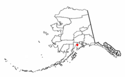
Location of Nikiski, Alaska
|
|
| Country | United States |
| State | Alaska |
| Borough | Kenai Peninsula |
| Area | |
| • Total | 75.93 sq mi (196.65 km2) |
| • Land | 69.48 sq mi (179.94 km2) |
| • Water | 6.45 sq mi (16.71 km2) |
| Elevation | 128 ft (39 m) |
| Population
(2020)
|
|
| • Total | 4,456 |
| • Density | 64.14/sq mi (24.76/km2) |
| Time zone | UTC-9 (Alaska (AKST)) |
| • Summer (DST) | UTC-8 (AKDT) |
| ZIP code |
99635
|
| Area code(s) | 907 |
| FIPS code | 02-54050 |
| GNIS feature ID | 1416651 |
Nikiski is a community located in Alaska, United States. It is known as a census-designated place (CDP). This means it's an area that the government uses for counting people and collecting statistics. However, it doesn't have its own local government like a city or town.
Nikiski is part of the Kenai Peninsula Borough. In 2020, about 4,456 people lived there. This number was a little lower than in 2010, when 4,493 people called Nikiski home.
Contents
Geography of Nikiski
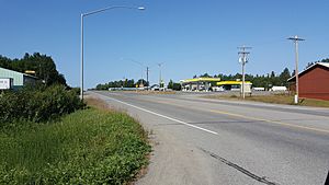
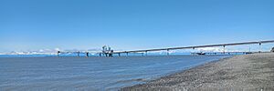
Nikiski is found on the western side of the Kenai Peninsula. It sits along the shore of Cook Inlet. This is a large body of water that connects to the Pacific Ocean.
To the south of Nikiski is the community of Salamatof. To the northeast, you'll find the Swanson River. Across the Swanson River is another community called Point Possession.
Land and Water Areas
Nikiski covers a total area of about 196.7 square kilometers (75.9 square miles). Most of this area, about 179.8 square kilometers (69.5 square miles), is land. The rest, about 16.8 square kilometers (6.5 square miles), is water.
The area where Nikiski is located is quite flat. It has many lakes, including:
- Stormy Lake
- Suneva Lake
- Daniels Lake
- Timberlost Lake
- Island Lake
- Foreland Lake
- Bernice Lake
- Cabin Lake
Getting Around Nikiski
The main road that helps people get to and from Nikiski is the Kenai Spur Highway. This highway goes south for about 11 miles to the city of Kenai. It also goes north to the Captain Cook State Recreation Area, which is a fun place for outdoor activities.
There is also another road called the Nikiski Emergency Escape Route. This road also leads south towards the city of Kenai.
People of Nikiski
Every ten years, the United States government counts its population. This is called a census. Nikiski first appeared in the U.S. Census way back in 1880. At that time, it was known as two small villages called "Kultuk" and "Titukilsk and Nikishka." Most of the people living there were Tinneh Natives.
Nikiski was not counted again until 1980. At that time, it was called "Nikishka" and was made a census-designated place (CDP). The name was changed to "Nikiski" in 1990, and it has been known by this name ever since.
Population Changes Over Time
| Historical population | |||
|---|---|---|---|
| Census | Pop. | %± | |
| 1880 | 74 | — | |
| 1980 | 1,109 | — | |
| 1990 | 2,743 | 147.3% | |
| 2000 | 4,327 | 57.7% | |
| 2010 | 4,493 | 3.8% | |
| 2020 | 4,456 | −0.8% | |
| U.S. Decennial Census | |||
In 2000, there were 4,327 people living in Nikiski. These people lived in 1,514 households, with 1,130 of them being families. A household is a group of people living together in one home.
Most people in Nikiski were White (87.2%). There were also Native American people (7.6%), Asian people (0.7%), and Pacific Islanders (0.5%). Some people were from other backgrounds or had mixed backgrounds. About 1.3% of the population was Hispanic or Latino.
Families and Ages
Many households in Nikiski (41.7%) had children under 18 living with them. Most households (60.9%) were married couples living together.
The average household had about 2.86 people. The average family had about 3.31 people.
The population of Nikiski has a good mix of ages:
- 33.5% were under 18 years old.
- 6.3% were between 18 and 24 years old.
- 29.8% were between 25 and 44 years old.
- 24.5% were between 45 and 64 years old.
- 5.9% were 65 years old or older.
The average age of people in Nikiski was 34 years.
Income and Economy
In 2000, the average income for a household in Nikiski was about $51,176 per year. For families, the average income was about $55,969 per year.
About 9.3% of families and 11.4% of all people in Nikiski lived below the poverty line. This means their income was below a certain level set by the government.
History of Nikiski
Nikiski was once home to a large fertilizer plant owned by a company called Agrium. This plant was a very important employer for the Kenai Peninsula Borough, meaning it provided many jobs for people in the area.
However, the plant closed in 2008. This happened because there wasn't enough natural gas available to keep it running. Even though it closed, the company has continued to look into the possibility of opening it again in the future.
Notable People from Nikiski
Nikiski has been home to some well-known individuals:
- Mike Chenault: He was the longest-serving speaker in the Alaska House of Representatives. A speaker is like the leader of the group of elected officials who make laws for the state.
- Mike Navarre: He is a politician who has been involved in government.
- Norman Olson: He is known as the owner of two private groups called militias.
See also
 In Spanish: Nikiski (Alaska) para niños
 | Janet Taylor Pickett |
 | Synthia Saint James |
 | Howardena Pindell |
 | Faith Ringgold |


