Noroton River facts for kids
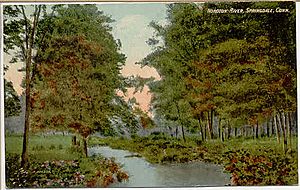
The Noroton River is a stream about 9.4-mile-long (15.1 km). It flows into a place called Holly Pond. This river also forms most of the border between the towns of Stamford and Darien in Connecticut, United States. The river starts in New Canaan, Connecticut. It is the biggest river between the Mill River/Rippowam River to the west and the Fivemile River to the east.
Sometimes, pollution from Interstate 95 washes into the Noroton River and then into Holly Pond. In 2009, the towns of Stamford and Darien asked the government for money. They wanted to clean up the pond and river. Their plan included building new wetlands and other structures to help the environment.
There are two restaurants near where the river meets U.S. Route 1. This road is also known as the Boston Post Road or East Main Street. Both restaurants have windows that let people see the river while they eat. One restaurant is in Stamford, and the other, Giovanni's II Steakhouse, is in Darien. Restaurants have been in that spot for a very long time!
Contents
Where is the Noroton River Located?
To the west of the Noroton River are the Glenbrook and Springdale areas of Stamford. To the east are the Noroton and Noroton Heights areas of Darien.
At its southern end, the river flows through a small valley. This valley is between Noroton Hill to the west and Hollow Tree Ridge to the east. Farther north, in New Canaan, Ponus Ridge is to the east.
Roads That Cross the Noroton River
Many roads cross the Noroton River. Here are some of them, listed from south to north:
- U.S. Route 1 (Boston Post Road in Darien, East Main Street in Stamford)
- Interstate 95
- Maple Tree Avenue (Stamford) / West Avenue (Darien)
- Connecticut Route 106 (Glenbrook Road in Stamford) / Middlesex Road (Darien)
- Camp Avenue
- Woodway Road
In New Canaan, these roads cross the river:
- C.T. Route 15 (the Merritt Parkway)
- Jelliff Mill Road (named after Jelliff Mill, where a dam creates Jelliff Mill Pond)
- Indian Waters Drive
- Frogtown Road
- Wahackme Road (the river flows through a bird sanctuary here)
- Greenley Road
- West Road
- Country Club Road
History of the Noroton River Area
The area around the Noroton River has a long and interesting history.
Early Settlements and Native Americans
Before English settlers arrived, the Siwanoy people lived here. They were part of the Wappinger tribe. There was an Indian village called "Noroaton" at the mouth of the river.
In the 1600s, the area became part of Stamford. One of the first English settlements in Darien was built near the river in the 1680s. It was on "Noroton Cove," which is now called Holly Pond. This settlement had a sawmill that used a dam on the river.
The Noroton River During the American Revolution
During the Revolutionary War, a man named Stephen Weed was released from a prison in New York City. He then built a stone fort near his home in New Canaan. This fort was on the east side of the river. He believed the British might attack by coming up the Noroton River valley. The area to the south, Middlesex Parish (now Darien), had been attacked many times during the war. Stephen Weed kept his fort ready for nine years, even after the war ended!
Changes in the 20th Century
In 1912, a newspaper article suggested taking a streetcar trip to see the Noroton River bridge. It said the area had lots of "historic interest" from the Revolutionary War. At that time, streetcars couldn't go all the way across the bridge. Passengers had to get off, walk across, and get on another streetcar. In 1914, the towns of Darien and Stamford agreed to make the bridge wider. This allowed electric streetcars to finally cross the river without stopping. This was the last missing link for streetcar service between New York City and Boston!
The Phillips family, who created Phillips Milk of Magnesia, owned a large house along the Noroton River in Glenbrook. In the mid-1980s, their property was turned into a housing complex called "River Walk."
A famous architect named Frank Lloyd Wright even worked on a part of the river! He reshaped a section of the river that ran through a large estate in New Canaan.
Flooding and River Challenges
On August 19, 1955, heavy rain caused the Noroton River to flood. Seven families in Darien had to leave their homes. A few months later, on October 16, more heavy rain caused the river to flood again. This time, the flood weakened the ground under the New Haven Line train tracks. Twenty freight train cars went off the tracks near the river in Stamford. Luckily, no one was hurt. After this flood, the river "twisted madly" through a big gap it had created in the train tracks.
 | Percy Lavon Julian |
 | Katherine Johnson |
 | George Washington Carver |
 | Annie Easley |


