
Norris, Tennessee facts for kids
Quick facts for kids
Norris, Tennessee
|
|
|---|---|

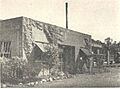
Post office and Archer's Food Center in Norris
|
|

Location of Norris in Anderson County, Tennessee.
|
|
| Country | United States |
| State | Tennessee |
| County | Anderson |
| Established | 1933 |
| Incorporated | 1949 |
| Named for | George W. Norris |
| Area | |
| • Total | 8.33 sq mi (21.58 km2) |
| • Land | 8.33 sq mi (21.58 km2) |
| • Water | 0.00 sq mi (0.00 km2) |
| Elevation | 1,079 ft (329 m) |
| Population
(2020)
|
|
| • Total | 1,599 |
| • Density | 191.89/sq mi (74.09/km2) |
| Time zone | UTC-5 (Eastern (EST)) |
| • Summer (DST) | UTC-4 (EDT) |
| ZIP code |
37705, 37828
|
| Area code(s) | 865 |
| FIPS code | 47-53600 |
| GNIS feature ID | 1295831 |
Norris is a small city in Anderson County, Tennessee. About 1,599 people lived there in 2020. It is part of the larger Knoxville, TN Metropolitan Statistical Area.
Norris was built in 1933 by the Tennessee Valley Authority (TVA). It was a special "planned community" designed to house workers who were building the Norris Dam on the Clinch River. The city is named after George W. Norris. He was a Senator from Nebraska who strongly supported the TVA project.
Contents
History of Norris, Tennessee
Building a Model Community
The TVA chairman, Arthur Ernest Morgan, wanted Norris to be a perfect example of a community. He imagined a place where people worked together and were treated equally. The city's design was inspired by the "garden city movement" from England in the 1890s.
The streets in Norris were winding, following the natural shape of the land. Houses were not always built facing the street. There was a central green space, like a park, for everyone to use. A wide area of natural land around the town was also set aside for residents.
Early Innovations in Norris
The houses in Norris were some of the first "all-electric" homes ever built. They used local wood and stone and came in twelve basic designs. Each house had a porch and a fireplace. Different outside materials were used to make the houses look unique.
Norris was the first town in the United States to use "greenbelt" design ideas. This means it had a natural, undeveloped area surrounding it. It was also the first town in Tennessee to have a full system of dial telephones. The Norris Creamery was the first milk-producing plant in the world to run only on electricity.
Challenges and Changes
In the 1930s, TVA officials did not allow black families to live in Norris. This made it a "sundown town," meaning black people were not welcome after dark. This was said to be because of local customs. However, black leaders pointed out that poor white and black people had lived and worked together in the area before the TVA arrived. The National Association for the Advancement of Colored People (NAACP) complained many times about this unfair treatment.
In 1948, the U.S. Congress decided that the city should be sold. A group of investors from Philadelphia bought Norris for $2.1 million. They then sold the individual homes to the people living in them. The city officially became an "incorporated" city in 1949. This means it became its own legal town with its own government. In 1953, the remaining land was sold to a company formed by Norris residents.
Norris Today
In 1975, the town of Norris, including 340 buildings and a large area of land, was added to the National Register of Historic Places. It was recognized as an "historic district" called the Norris District.
Today, Norris is mostly a "bedroom community." This means many people who live there travel to work in nearby cities like Knoxville and Oak Ridge. The city has an elementary school (grades K-5) and a middle school (grades 6-8). High school students attend Anderson County High School. There is also a small grocery store and other local businesses.
Norris is home to the Museum of Appalachia, which is a popular place to visit. It is also close to Norris Dam State Park and Big Ridge State Park, which are great for camping.
Geography and Natural Features
Norris is located in the northern part of Anderson County. It sits on hills south of the Clinch River. U.S. Route 441, also known as the Norris Freeway, goes around the west side of the city. This road leads south about 21 miles (34 km) to Knoxville. It also goes northwest about 10 miles (16 km) to Rocky Top. Interstate 75 is about 2 miles (3 km) southwest of Norris. You can get to it using Tennessee State Route 61.
The city covers about 8.33 square miles (21.58 square kilometers) of land. A large part of this area is the Norris Municipal Watershed. This watershed is over 2,200 acres (890 hectares) and helps supply water to the city. It is also used for fun activities, growing timber, and protecting wildlife, including deer hunting. There are almost 20 miles (32 km) of trails for hiking and other recreation in the watershed area.
Population and Demographics
Population Growth Over Time
The population of Norris has changed over the years. Here is a look at how many people have lived in the city during different census years:
| Historical population | |||
|---|---|---|---|
| Census | Pop. | %± | |
| 1950 | 1,134 | — | |
| 1960 | 1,389 | 22.5% | |
| 1970 | 1,359 | −2.2% | |
| 1980 | 1,374 | 1.1% | |
| 1990 | 1,303 | −5.2% | |
| 2000 | 1,446 | 11.0% | |
| 2010 | 1,491 | 3.1% | |
| 2020 | 1,599 | 7.2% | |
| Sources: | |||
Norris in 2020
In the 2020 United States census, there were 1,601 people living in Norris. There were 585 households and 330 families. Most of the people living in Norris were White (non-Hispanic), making up about 93.81% of the population.
Images for kids
-
Hydraulics laboratory building in the 1930s

See also
 In Spanish: Norris (Tennessee) para niños
