
Norristown, Arkansas facts for kids
Quick facts for kids
Norristown, Arkansas
|
|
|---|---|
|
19th century river settlement and, later, neighborhood in Russellville
|
|

This 1877 map shows Dardanelle and Norristown on the Arkansas River. It also shows roads, properties, and land features.
|
|

Norristown, Arkansas
Location in Arkansas

Norristown, Arkansas
Location in the United States
|
|
| Country | United States |
| State | Arkansas |
| County | Pope |
| Elevation | 548 ft (167 m) |
| Time zone | UTC-6 (Central (CST)) |
| • Summer (DST) | UTC-5 (CDT) |
| GNIS feature ID | 79314 |
Norristown was a small town in Arkansas during the 1800s. It started as an important trading spot on the Arkansas River. Later, it became an official town on Norristown Mountain. On August 14, 1980, Norristown joined with the nearby city of Russellville.
Contents
History of Norristown
Early Settlement and Growth
Norristown was founded in 1829. It was located south of Russellville, right on the Arkansas River. It was also across the river from Dardanelle.
A couple named Samuel and Susan H. Norris, who were from New Jersey, started the settlement. They named the place Norristown. The town grew steadily, and soon about 300 to 400 people lived there.
Norristown as County Seat
By 1834, Norristown was a small community. It became the "county seat" for Pope County. A county seat is the main town where the county government is located.
However, in 1841, Yell County was created. This meant Norristown was no longer in the center of Pope County. So, the county seat was moved to Dover.
A Hub for Trade and Travel
Norristown was an important center for trade and shipping. This was because it was on the Arkansas River, which boats could use during certain seasons. It was also on a main mail road. The town's main tavern was a key stop for travelers between Little Rock and Fort Smith.
Thousands of cotton bales were loaded onto steamboats in Norristown. These boats would carry the cotton to Little Rock and even to New Orleans. During the American Civil War, heavy equipment for mining was brought by river to Norristown.
Town Layout and Post Office
The town of Norristown was laid out in a shape that looked like a capital "T". Its two main streets did not have official signs. However, people called them "River Street" and "Main Street".
Norristown had its own post office. It opened in 1839 with Samuel Norris as the postmaster. The post office closed in 1882.
The Trail of Tears
During the 1830s and 1840s, a sad event called the Trail of Tears happened. This was when many Native American groups from the eastern United States were forced to move to Indian Territory. Thousands of these people passed through Norristown. Many of them crossed the river using the ferry located there.
Cephas Washburn's Influence
In 1855, Cephas Washburn moved to Norristown. He was a minister who had founded the Dwight Presbyterian Mission nearby. In Norristown, he continued his work as a minister. He helped start Presbyterian churches in Dardanelle and Galley (Galla) Rock.
Decline of the Town
Norristown was active throughout the mid-1800s. But by the end of the century, not much was left. The Arkansas River's water levels could change a lot. Also, a new railroad was built through nearby Russellville. This meant that riverboat shipping became less important. Small river towns like Norristown began to disappear.
In 1898, a flood caused part of the town to fall into the river. The rest of the land was turned into farms. Today, the only remaining part of the old town is the Norristown Cemetery. It was used from 1852 to 1934 and is now listed as a historic place.
Norristown Today
The original site of Norristown is now a park called Old Post Road Park. It is a recreation area managed by the US Army Corps of Engineers. The park's name comes from the first postal route in this part of Arkansas, which went through Norristown. In the 1830s, a ferry crossed the river from where the park's boat ramp is now.
In the 1900s, a new community also called Norristown grew up. It was located on and around Norristown Mountain. This mountain is a long ridge between Russellville and the Arkansas River. This new Norristown became an official town. However, it later joined with Russellville on August 14, 1980.
Gallery
-
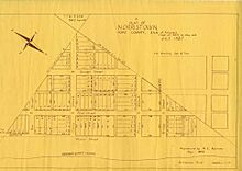
A map of Norristown, Pope County, Arkansas, from July 1837.
-
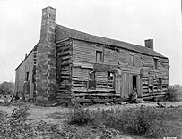
This old log home of Cephas Washburn in Norristown was still being used in 1930, when this photo was taken.


