
North Arm, Queensland facts for kids
Quick facts for kids North ArmSunshine Coast, Queensland |
|||||||||||||||
|---|---|---|---|---|---|---|---|---|---|---|---|---|---|---|---|

North Arm
Location in Queensland
|
|||||||||||||||
| Population | 734 (2021 census) | ||||||||||||||
| • Density | 32.33/km2 (83.7/sq mi) | ||||||||||||||
| Postcode(s) | 4561 | ||||||||||||||
| Area | 22.7 km2 (8.8 sq mi) | ||||||||||||||
| Time zone | AEST (UTC+10:00) | ||||||||||||||
| LGA(s) | Sunshine Coast Region | ||||||||||||||
| State electorate(s) |
|
||||||||||||||
| Federal Division(s) | Fairfax | ||||||||||||||
|
|||||||||||||||
North Arm is a small town and area in the countryside of the Sunshine Coast Region in Queensland, Australia. In 2021, about 734 people lived in North Arm.
Contents
Exploring North Arm's Location

North Arm is located inland from the coast. It's part of the beautiful Sunshine Coast area. The town gets its name from the North Maroochy River. This river flows right through the area.
The main road, called the Bruce Highway, goes through North Arm. It runs from the south to the north. The North Coast railway line also passes by. It runs next to the highway on the east side. North Arm has its own railway station.
What is Gneering?
There is a smaller area called Gneering in North Arm. It is located in the south-west part of the town.
A Look Back at North Arm's History
.jpg)
The name North Arm comes from its closeness to the northern part of the Maroochy River.
Early Settlers and Farming
In 1868, the Canando Cattle Run was opened up. This area included North Arm. People could choose land to settle on. Some land near Mount Ninderry was saved for timber.
In 1886, Friedrich Goethe planted the first sugarcane in North Arm. At that time, there was no mill to crush the sugarcane. Growing sugarcane became an important farm industry for the next 100 years.
Schools and Community Life
Fairhill Provisional School first opened on July 27, 1885. It became Fairhill State School in 1909. In October 1915, its name changed to North Arm State School.
The North Arm Hall opened in 1914. It was a very important place for social events for 40 years. A cyclone destroyed it in 1954. But the community later rebuilt it.
Other schools also existed in the area. Brown's Creek State School opened in 1918. It closed in 1936. Golden Valley State School opened in 1918. It was renamed Valdora State School in 1940. This school building was moved in 1949 and became Yandina Creek State School. It closed in 1964.
Education in North Arm
North Arm State School is a government primary school. It teaches students from Prep to Year 6. Boys and girls attend this school. It is located at the corner of Fairhill and Yandina Creek Road. In 2018, the school had 351 students. There were 30 teachers and 23 other staff members.
What North Arm Offers
North Arm has a forest reserve. This natural area is located on the edge of town.
Images for kids
-
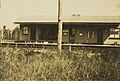
North Arm railway station, circa 1925
-
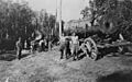
Bullockies standing near bullock carts carrying logs in North Arm, circa 1920
