Ninderry, Queensland facts for kids
Quick facts for kids NinderryQueensland |
|||||||||||||||
|---|---|---|---|---|---|---|---|---|---|---|---|---|---|---|---|

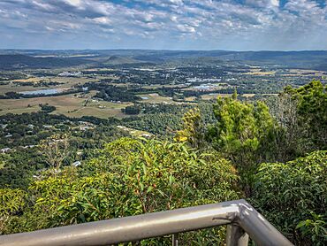
View of Yandina from Mount Ninderry, 2018
|
|||||||||||||||
| Population | 1,301 (2021 census) | ||||||||||||||
| • Density | 149.5/km2 (387/sq mi) | ||||||||||||||
| Postcode(s) | 4561 | ||||||||||||||
| Area | 8.7 km2 (3.4 sq mi) | ||||||||||||||
| Time zone | AEST (UTC+10:00) | ||||||||||||||
| Location | |||||||||||||||
| LGA(s) | Sunshine Coast Region | ||||||||||||||
| State electorate(s) | Ninderry | ||||||||||||||
| Federal Division(s) | Fairfax | ||||||||||||||
|
|||||||||||||||
Ninderry is a rural town and area in the Sunshine Coast Region, Queensland, Australia. It is a quiet place with lots of nature. In 2021, about 1,301 people called Ninderry home.
Contents
Exploring Ninderry's Geography
Ninderry is surrounded by natural features. The Bruce Highway and the North Coast railway line are to the north-west. The North Maroochy River forms the south-western boundary. The Ninderry Range ridgeline is generally to the east.
Mountains and Hills
Ninderry has two main mountains:
- Fair Hill: This mountain is in the north-west. It rises to about 148 meters (486 feet) above sea level.
- Mount Ninderry: Located in the south-east, this mountain is taller. It reaches about 312 meters (1,024 feet) high.
Land Use and Nature
Around the edges of nearby Yandina, much of the land is used for homes with large yards. However, some areas still have farms. The natural landscape is a big part of Ninderry's charm.
Ninderry's History and Name
The town of Ninderry gets its name from the Ninderry Range. The name comes from the Kabi language word nyindur or durree. This word means "place of scrub leeches."
Ninderry's Population Growth
The number of people living in Ninderry has been growing.
- In 2016, about 1,087 people lived in the area.
- By 2021, the population had grown to 1,301 people.
Learning and Schools Near Ninderry
Ninderry itself does not have any schools. Students usually go to schools in nearby towns.
- For primary school, children can attend Yandina State School in Yandina. North Arm State School in North Arm is also an option.
- For high school, the closest government school is Nambour State College in Nambour.
Community Groups in Ninderry
Ninderry is home to some important community groups. These groups work to protect the local environment.
- Maroochy Landcare: This group helps care for the land.
- Maroochy Mooloola Catchment Coordinating Association: This group also works on environmental projects.
Both groups are part of the larger Landcare Australia network.
Parks and Green Spaces
Ninderry has several parks and natural reserves where people can enjoy the outdoors:
- Collins Road Natural Amenity Reserve
- George Best Park
- Honeydew Place Natural Amenity Reserve
- Leach Park
- Mount Ninderry Bushland Conservation Reserve
- North Maroochy River Esplanade – Yandina
- Old Coach Way Bushland Conservation Reserve
- Old Coach Way Park
Fun Things to Do: Mount Ninderry Views
One popular activity is hiking up Mount Ninderry. The bushwalk leads to two lookouts. From these spots, you can see amazing panoramic views. You can look east towards Mount Coolum and west towards Yandina.
 | Misty Copeland |
 | Raven Wilkinson |
 | Debra Austin |
 | Aesha Ash |


