Eerwah Vale, Queensland facts for kids
Quick facts for kids Eerwah ValeSunshine Coast, Queensland |
|||||||||||||||
|---|---|---|---|---|---|---|---|---|---|---|---|---|---|---|---|

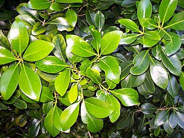
Planchonella eerwah or Pouteria eerwah
|
|||||||||||||||
| Population | 671 (2021 census) | ||||||||||||||
| • Density | 21.23/km2 (55.0/sq mi) | ||||||||||||||
| Postcode(s) | 4562 | ||||||||||||||
| Area | 31.6 km2 (12.2 sq mi) | ||||||||||||||
| Time zone | AEST (UTC+10:00) | ||||||||||||||
| Location |
|
||||||||||||||
| LGA(s) |
|
||||||||||||||
| State electorate(s) |
|
||||||||||||||
| Federal Division(s) | |||||||||||||||
|
|||||||||||||||
Eerwah Vale is a small place, also called a locality, in Queensland, Australia. It's split between two local government areas: the Sunshine Coast Region and the Shire of Noosa. In 2021, about 671 people lived here.
Contents
Exploring Eerwah Vale's Geography
Eerwah Vale has some cool natural features. The North Maroochy River forms part of its northern edge. A big road called the Bruce Highway runs through the eastern side. East of this highway, you'll find Main Camp Road. Right in the middle of Eerwah Vale is Mount Eerwah. This mountain is a special protected area called the Mount Eerwah Conservation Park.
A Look Back at Eerwah Vale's History
The area was first known simply as Eerwah, named after the nearby Mount Eerwah. In 1890, the local post office changed its name to Mount Eerwah Post Office. This post office served the Main Camp area. It was especially busy when the North Coast railway line was being built from Caboolture to Gympie. Mr. Edward H. Arundell was in charge of this post office.
Early Schools in Eerwah Vale
The first Mount Eerwah Provisional School opened in 1890. It was for the children of the railway workers. This school only stayed open for about a year, closing in 1891. After the railway was finished, people moved closer to the new Eumundi railway station.
A second Mount Eerwah State School opened on July 22, 1913. It was located on Eumundi Kenilworth Road. This area was called "Koojarewon." However, there was already a school with a similar name near Toowoomba. So, the school was named Mount Eerwah. This school closed on May 31, 1917. Its building was later moved and became the Brown's Creek Provisional School.
Brown's Creek State School opened on January 29, 1918. It was located near King Creek and Browns Creek, in the area now known as Eerwah Vale. This school operated until August 23, 1936.
The Eerwah Vale Provisional School opened on June 15, 1925. In 1932, it became the Eerwah Vale State School. This school closed in 1963. Its old location was at 438 Eumundi Kenilworth Road.
Community and Local Government Changes
In 1924, people in the area decided to build a public hall. This was the first time the name "Eerwah Vale" was officially mentioned for the locality.
Between 2008 and 2013, Eerwah Vale was part of the Sunshine Coast Region. After 2013, it became split between the Sunshine Coast Region and the Shire of Noosa.
Who Lives in Eerwah Vale?
The number of people living in Eerwah Vale has slowly grown over the years:
- In 2011, there were 527 people.
- In 2016, the population grew to 621 people.
- By 2021, 671 people called Eerwah Vale home.
Schools Near Eerwah Vale
There are no schools directly in Eerwah Vale. Students usually go to schools in nearby towns.
- For primary school, kids might attend Eumundi State School in Eumundi, Cooroy State School in Cooroy, North Arm State School in North Arm, or Yandina State School in Yandina.
- For high school, students can go to Noosa District State High School. Its junior campus is in Pomona and its senior campus is in Cooroy. Another option is Nambour State College in Nambour.
Special Plants in Eerwah Vale
One very special plant found here is the Planchonella eerwah, also known as Pouteria eerwah. People also call it Shiny-leaved Condoo, Black Plum, or Wild Apple. This unique tree is considered an endangered species by both the Australian and Queensland Governments, meaning it needs special protection to survive.
 | Laphonza Butler |
 | Daisy Bates |
 | Elizabeth Piper Ensley |


