North Coogee facts for kids
Quick facts for kids North CoogeePerth, Western Australia |
|||||||||||||||
|---|---|---|---|---|---|---|---|---|---|---|---|---|---|---|---|

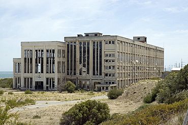
South Fremantle Power Station
|
|||||||||||||||
| Established | 2005 | ||||||||||||||
| Postcode(s) | 6163 | ||||||||||||||
| Area | 2.8 km2 (1.1 sq mi) | ||||||||||||||
| Location | 23 km (14 mi) from Perth | ||||||||||||||
| LGA(s) | City of Cockburn | ||||||||||||||
| State electorate(s) | Fremantle | ||||||||||||||
| Federal Division(s) | Fremantle | ||||||||||||||
|
|||||||||||||||
North Coogee is a beautiful coastal suburb located west of Perth, Western Australia. It's part of the City of Cockburn. This area is just north of Coogee.
The name Coogee comes from the local Aboriginal Nyoongar language. It means "Body of water," referring to Lake Coogee nearby. Long ago, this lake was called Lake Munster. The Aboriginal name Kou-gee was first written down in 1841. It has been spelled in a few ways, like Koojee and Coojee.
North Coogee became its own suburb on December 19, 2005. It was created from parts of other nearby suburbs like Hamilton Hill, Spearwood, and Coogee.
Contents
Where is North Coogee Located?
North Coogee is about 4 kilometers south of Fremantle. To the north, it borders the City of Fremantle. To the east, you'll find Cockburn Road and Beeliar Regional Park. Powell Road is to the south, and Cockburn Sound is to the west.
From North Coogee, you can see amazing views of Cockburn Sound. You can also spot Garden Island, Carnac Island, and Rottnest Island in the distance.
A Look at North Coogee's Past
The first known development in this area happened in 1831. A man named Richard Goldsmith Meares built a kiln to burn lime, which was used for building. He later moved away.
Because the area was close to Owen's Anchorage, a safe harbor in Cockburn Sound, ships started using it as a place to arrive.
The land was first given to George Robb. Later, around 1900, many commercial lime kilns were built here. These kilns helped provide materials for the building boom that happened because of gold discoveries.
The area became very industrial, with many factories and businesses. For example, the Fremantle Smelting Works processed lead. Next to it was a slaughter house run by Copley & Co. This was the same spot where John Wellard had processed sheep back in the 1850s.
Further south, at Robb Jetty, there were more slaughter houses. These places supplied most of the meat for the city and the growing goldfields. Livestock arrived by ship from places like the Kimberley Region. Since there wasn't much cold storage, large areas were used for animals to graze. Small market gardens also grew nearby.
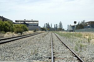
In 1898, a railway line was built from Fremantle to Robb Jetty. The slaughter houses grew, adding a bone mill and sheds for drying skins. An explosives storage building was also built in the sandhills. Later, a pig farm and bacon factory were built south of Robb Jetty.
In 1903, the railway was extended to Woodman Point. The explosives storage was moved there, further away from Fremantle.
Over time, North Coogee became a center for heavy industry in Perth. It had a coal power station, railway yards, and many skin drying sheds. However, starting in the 1980s, people wanted more homes. This led to many of the industrial sites being removed.
Old Railway Yards
A large railway yard was built in the 1960s. It was part of a big project to build a standard gauge railway line from Kalgoorlie to Leighton. This yard was used to sort and move trains.
The railway yard stopped being used in the 1990s.
Robb Jetty Abattoir: A Look Back
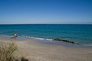
The abattoir, which was a place where animals were processed for meat, closed in 1994. The jetty itself was taken apart in the 1960s. Today, only the pylons (tall posts) of the old jetty remain. They stretch about 200 to 300 meters into the sea. The tall chimney is the only part left of the many buildings that once stood there. This chimney is now listed as a heritage place.
South Fremantle Power Station's Story
Building the South Fremantle Power Station started in 1946. This location was chosen because it was close to many people, had railway lines for coal delivery, and could easily use seawater for cooling. The first parts of the power station began working in 1951. The official opening was on June 27, 1951. By December 1954, the power station was fully complete. It could produce 100 megawatts of electricity.
Many parts of the power station were made in Great Britain. Skilled workers from Britain came to Australia to put everything together. The State Energy Commission helped staff find homes in the Hilton Park area. A bus service was even provided for workers. In the 1950s, over 250 people worked at the power station.
In 1954, a big fire damaged the coal conveyor. This caused the power station to switch from burning coal to oil. In the mid-1970s, it went back to using coal. The station closed in 1985 because it was too expensive to make electricity there. Newer power stations closer to coal sources were more efficient.
In September 1985, the South Fremantle Power Station closed after 34 years. Its four tall chimney stacks were later taken down.
North Coogee Today: New Developments
South Beach Area
In 2002, the government and a company called Stockland wanted to build homes on the land where old factories and railway yards used to be. Some local residents formed a group called Save South Beach. They were worried about pollution, coastal erosion, and noise from trains. Even with protests, the building started, and the first homes were ready in 2005.
Port Coogee/Point Catherine
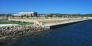
In 1992, the government agreed to develop a residential marina in the Coogee area. A marina is a place where boats are kept. In 1996, an agreement was made with Port Catherine Developments. Another group, Coogee Coastal Action Coalition, was against this project. They worried about losing beaches, coastal erosion, and effects on seagrass. Since then, a company called Australand Property Group has taken over. Work on the marina has started, and the first homes were available in 2007.
Cockburn Coast Vision
In 2008, the government shared its plan for the old industrial area between South Beach and the Port Coogee marina. They proposed to turn 95 hectares of coastal land into homes for about 10,000 people.
Getting Around North Coogee
Bus Services
- Bus route 512 goes from Fremantle Station to Murdoch Station. It travels along Cockburn Road, Pantheon Avenue, and Orsino Boulevard.
- Bus route 548 goes from Fremantle Station to Rockingham Station. It also uses Cockburn Road, Pantheon Avenue, and Orsino Boulevard.
 | Sharif Bey |
 | Hale Woodruff |
 | Richmond Barthé |
 | Purvis Young |


