Beeliar Regional Park facts for kids
Quick facts for kids Beeliar Regional Park |
|
|---|---|

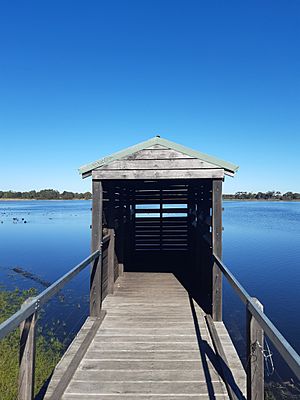
Bird hide at Bibra Lake
|
|
| Type | Regional park |
| Location | Cockburn Kwinana Melville |
| Area | 3,171 ha (7,840 acres) |
| Established | 17 January 1995 |
| Administered by | Department of Biodiversity, Conservation and Attractions |
| Official name | Beeliar Regional Park |
| Type | Interim list (Natural) |
| Designated | 24 June 1997 |
| Reference no. | 14862 |
Beeliar Regional Park is a special nature park located about 19 kilometers south of Perth, Western Australia. It stretches across three cities: Cockburn, Kwinana, and Melville. The park gets its name from the Beeliar people, who are the original Indigenous inhabitants of this land.
In Western Australia, regional parks are important places. They protect amazing nature, beautiful landscapes, and offer fun outdoor activities. Beeliar Regional Park includes parts of the Beeliar Wetlands. These wetlands were once much larger across the Swan Coastal Plain.
Beeliar is one of eleven regional parks in the Perth area. These parks act like green havens in the city. They help protect and restore important cultural history and valuable natural areas. They also encourage people to enjoy nature in a way that helps keep it healthy.
Contents
A Look Back: Park History
The idea for public parks in Western Australia started a long time ago. In 1955, a report suggested saving private land for future public use. This land would later become part of the Perth Metropolitan Region in 1963.
Later, in 1983, the Environmental Protection Authority (EPA) found areas that were very important for nature, scenery, and recreation. In 1989, the state Government gave the job of managing these regional parks to the Department of Conservation and Land Management.
A special team was set up in 1990 to create these parks. However, the EPA reported in 1993 that setting them up was difficult. Finally, Beeliar Regional Park was officially created on January 17, 1995.
Ancient Stories: Cultural Heritage
The area of Beeliar Regional Park was very important to the Beeliar clan. They are part of the Noongar nation's Whadjuk people. The park's freshwater lakes were a key place for camping and finding food.
A major trade route once passed through these wetlands. It connected the Swan River and the Murray River. Many Aboriginal heritage sites have been found in the park. This area is still very spiritually important to the local Indigenous people today.
European settlement in this area was slow. Much of the land was not good for farming. Early attempts to build a town in the 1830s failed. By the 1920s, many canals were built to drain the wetlands. This was done to make the land ready for farming.
Exploring the Park: Lakes and Lands
Beeliar Regional Park stretches a long way. It goes from Blue Gum Lake in the north, about 10 km south of Perth's city center. It extends all the way to The Spectacles in the south, about 33 km from the city.
The park has 19 lakes, arranged in two chains. The smaller, western chain is close to the coast, within 2 km. The eastern, larger chain is further inland, about 5 to 6 km from the coast. The park also includes the Henderson coastal limestone cliffs.
Eastern Lakes Chain
Here are the main areas in the eastern chain, from north to south:
| Image | Name | Suburb | Description | Co-ordinates |
|---|---|---|---|---|
 |
Blue Gum Reserve | Mount Pleasant | 32°02′16″S 115°50′52″E / 32.03771°S 115.847662°E | |
 |
Booragoon Lake | Booragoon | 32°02′40″S 115°50′34″E / 32.0444°S 115.8427°E | |
 |
Piney Lakes | Winthrop | 32°02′55″S 115°50′16″E / 32.048673°S 115.837744°E | |
 |
North Lake | North Lake | 32°04′40″S 115°49′30″E / 32.07778°S 115.8250°E | |
 |
Bibra Lake | Bibra Lake | 32°05′28″S 115°49′27″E / 32.091108°S 115.824257°E | |
| South Lake | Bibra Lake | 32°06′14″S 115°49′07″E / 32.103889°S 115.818611°E | ||
| Cocos Reserve | Bibra Lake | 32°06′30″S 115°49′23″E / 32.108277°S 115.822918°E | ||
| Little Rush Lake | Yangebup | 32°06′37″S 115°49′31″E / 32.110278°S 115.825278°E | ||
 |
Yangebup Lake | Yangebup | 32°07′06″S 115°49′48″E / 32.1183°S 115.8300°E | |
 |
Kogolup Lake | Beeliar | 32°08′09″S 115°49′51″E / 32.135833°S 115.830833°E | |
| Branch Circus Wetland | Beeliar | 32°08′15″S 115°50′24″E / 32.137497°S 115.840023°E | ||
 |
Thomsons Lake | Beeliar | This is an important wetland. It is fenced to keep out pests. It is home to the endangered Southern brown bandicoot. | 32°09′00″S 115°49′44″E / 32.1500°S 115.8290°E |
| Banganup Lake | Wattleup | This lake is inside the fenced Harry Waring Marsupial Reserve. | 32°09′55″S 115°49′37″E / 32.165274°S 115.827041°E | |
 |
The Spectacles | The Spectacles | This area has an Aboriginal Heritage Trail and the Biara Boardwalk Trail. The boardwalk leads to a bird hide. | 32°12′54″S 115°50′02″E / 32.2150°S 115.8339°E |
Western Lakes Chain
Here are the main areas in the western chain, from north to south:
| Image | Name | Suburb | Description | Co-ordinates |
|---|---|---|---|---|
 |
Manning Lake | Hamilton Hill Spearwood |
This is the site of the historic Azelia Ley Homestead. | 32°05′33″S 115°46′19″E / 32.0925°S 115.7719°E |
 |
Market Garden Swamp 1 | Spearwood | 32°06′44″S 115°46′44″E / 32.112294°S 115.778963°E | |
 |
Market Garden Swamp 2 | Lake Coogee | 32°07′30″S 115°46′49″E / 32.125030°S 115.780264°E | |
 |
Lake Coogee | Lake Coogee | 32°08′06″S 115°46′36″E / 32.1350°S 115.7767°E | |
| Brownman Swamps | Henderson | 32°09′54″S 115°47′14″E / 32.165128°S 115.787342°E | ||
 |
Lake Mount Brown | Henderson | 32°10′24″S 115°47′23″E / 32.173333°S 115.789833°E | |
 |
Mount Brown | Henderson & Naval Base |
This spot has a lookout with great views of the area and Cockburn Sound. | 32°10′54″S 115°47′00″E / 32.1817°S 115.7833°E |
 |
Henderson Foreshore | Henderson & Naval Base |
This area has a lookout and a short walk along the cliff top. You can see Garden Island and Carnac Island from here. | 32°10′24″S 115°46′20″E / 32.173330°S 115.772125°E |
 | Georgia Louise Harris Brown |
 | Julian Abele |
 | Norma Merrick Sklarek |
 | William Sidney Pittman |

