North Fork Umatilla River facts for kids
Quick facts for kids North Fork Umatilla River |
|
|---|---|

North Fork Umatilla River
|
|
|
Location of the mouth of the North Fork Umatilla River in Oregon
|
|
| Country | United States |
| State | Oregon |
| County | Union, Umatilla |
| Physical characteristics | |
| Main source | Blue Mountains Umatilla National Forest, Union County 5,102 ft (1,555 m) 45°42′17″N 118°02′05″W / 45.70472°N 118.03472°W |
| River mouth | Umatilla River near Graves Butte, Umatilla County 2,326 ft (709 m) 45°43′32″N 118°11′19″W / 45.72556°N 118.18861°W |
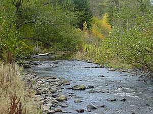
The North Fork Umatilla River is a river in Oregon, a state in the United States. It's like a smaller stream that flows into a bigger river. This river joins the Umatilla River. You can find it in Union and Umatilla counties.
The river starts high up in the Blue Mountains. This area is part of the Umatilla National Forest. From there, it flows mostly towards the northwest. Eventually, it meets another river called the South Fork Umatilla River. When these two rivers meet, they form the main Umatilla River.
Near where it begins, the North Fork Umatilla River flows north. It runs alongside Oregon Route 204, north of a town called Elgin. After that, it turns west and flows through a special protected area. This area is known as the North Fork Umatilla Wilderness. Several smaller streams, called tributaries, flow into the North Fork. These include Johnson Creek, Woodward Creek, and Coyote Creek.
Contents
Fun Things to Do Along the River
The North Fork Umatilla River area is a great place for outdoor activities. There are many ways to explore and enjoy nature here.
North Fork Umatilla Wilderness Trails
About 30 miles (48 km) east of Pendleton, you'll find the North Fork Umatilla Wilderness. This wild area has about 27 miles (43 km) of trails. These trails are perfect for hiking and riding horses. A part of the North Fork Umatilla Trail follows the river itself. It's a beautiful path to explore.
Umatilla Forks Campground
Near where the North Fork and South Fork rivers meet, there's a place called Umatilla Forks Campground and Day Use Area. The United States Forest Service manages this spot. It's usually open from June through September. Here, you can find campsites, picnic tables, and restrooms. There's also drinking water and parking. Besides hiking, people enjoy fishing, hunting, and watching wildlife in this area.
Woodland Campground and Sno-Park
Another Forest Service campground, Woodland Campground, is located near the river's start. It's right along Route 204. This campground stays open until November. It offers tent sites, restrooms, and picnic tables. You can also get to hiking trails from here, but remember to bring your own drinking water.
Just a little north of Woodland Campground, along the highway, is Woodland Sno-Park. This park is also run by the Forest Service. Local clubs help take care of the park, especially its snowmobile trails. The Sno-Park is usually open from November to April. It's a popular spot for people who like to snowshoe, do Nordic skiing, and, of course, snowmobile. It has parking and a vault toilet. The Oregon Department of Transportation helps keep the roads clear of snow here.
 | Calvin Brent |
 | Walter T. Bailey |
 | Martha Cassell Thompson |
 | Alberta Jeannette Cassell |


