
Zion Canyon facts for kids
Quick facts for kids Zion Canyon |
|
|---|---|
| Mukuntuweap | |

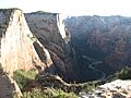
Zion Canyon from Angels Landing at sunset
|
|

Zion Canyon
Location in Utah
|
|
| Floor elevation | 4,300 feet (1,300 m) |
| Geography | |
| Rivers | North Fork Virgin River |
Zion Canyon is a deep, narrow valley in southwestern Utah, United States. It is also known by names like Little Zion and Mukuntuweap. The word weap means "canyon" in the Paiute language. This amazing canyon was carved out by the North Fork of the Virgin River. Almost all of Zion Canyon is found within the western part of Zion National Park.
Contents
Exploring Zion Canyon's Features

The canyon usually starts at a place called the Temple of Sinawava. This is a natural amphitheater with very tall, straight walls. It is almost 3,000 feet (914 meters) deep. However, the canyon actually begins much further upstream. It runs south for about 16 miles (26 kilometers) through an area called the Narrows.
The Zion Narrows: A Unique Hike

The Narrows is where the canyon floor is very narrow, sometimes only 20 feet (6 meters) wide. A seasonal waterfall plunges over a tall cliff here during spring and after heavy rains. The canyon then winds southwest through the national park. In some places, it is nearly 2,000 feet (610 meters) deep.
Life in the Canyon: Desert and River Oasis
While the top edges of the canyon are dry desert, the bottom of the canyon is very different. It has a forest and a special area called a riparian zone. This area is watered by the North Fork Virgin River. The canyon then joins Pine Creek Canyon as it leaves the national park. It passes by the town of Springdale. Zion Canyon ends where it meets the main Virgin River. This is about 100 miles (160 kilometers) northeast of Lake Mead. The river eventually flows into Lake Mead.
Getting Around Zion Canyon
Two main roads help visitors explore the canyon: Zion Canyon Drive and the Zion-Mount Carmel Highway. Zion Canyon Drive ends at the Temple of Sinawava. From there, the Riverside Walk trail follows the river upstream to the start of the Zion Narrows.
You can hike in the Narrows when the water levels are low. But be careful! Flash floods can happen very quickly after heavy rainstorms. This is because many areas in Zion Canyon have little or no soil. This means water runs off very fast when it rains. In contrast, most of the main Zion Canyon floor is wide, about 1,000 feet (305 meters). It is rich with soil brought by the river. Smaller streams like Deep, Kolob, Goose, Pine, and Oak Creeks also flow into the river within the canyon.
How Zion Canyon Was Formed

Zion Canyon is part of a large rock area called the Colorado Plateau. This area is made of a type of rock called Navajo Sandstone. When the land was first pushed up, it had many cracks. The North Fork of the Virgin River began to cut into one of these cracks, forming Zion Canyon.
The Power of Water and Erosion
The river was the main force that carved the canyon. Most of the carving happened because of flash floods. Even though the river's normal flow is gentle, these powerful floods quickly cut down through the rock. This fast cutting has left many smaller streams with "hanging valleys." These are valleys that are much higher than the main canyon floor. Some of the largest streams have cut down almost as deep as the main canyon.
Erosion continues to shape the canyon walls. It creates natural arches and other amazing rock formations. Scientists believe the Virgin River can still cut down another 1,000 feet (305 meters) through the rock. Another force that widens the canyon is called Mass wasting. This often happens when ice freezes in cracks in the canyon walls, pushing the rock apart.
Water in the Canyon: Springs and Stability
The Navajo Sandstone is a soft rock that erodes easily. It also has many tiny holes, making it very porous. The canyon's geology is often unstable. Sometimes, large rockslides have blocked the river, forming temporary lakes. The most recent one was about 4,000 years ago. Because the canyon is so deep, many springs flow from the surrounding groundwater. These springs keep water flowing in the canyon all year long.
A Brief History of Zion Canyon
Mormon settlers arrived in the Zion Canyon area in the late 1850s. A settler named Isaac Behunin gave the canyon its name. He named it after a "place of peace" mentioned in the Bible. Explorer John Wesley Powell is said to have given the canyon the name Mukuntuweap. This was supposedly the native name for the canyon.
In 1909, Zion Canyon was first protected as a national monument. Then, in 1919, it was officially declared a national park. The Zion-Mount Carmel Highway, which goes through Pine Creek Canyon and the lower part of Zion Canyon, first opened in 1930.
Images for kids
-
Zion Canyon from the trail to Observation Point.

