
Angels Landing facts for kids
Quick facts for kids Angels Landing |
|
|---|---|

Location in Utah

Location in the United States
|
|
| Highest point | |
| Prominence | 430 ft (130 m) |
| Isolation | 0.3 mi (0.48 km) |
| Parent peak | Cathedral Mountain (6,930 ft) |
| Geography | |
| Location | Zion National Park, Washington County, Utah |
| Topo map | USGS Temple of Sinawava |
| Geology | |
| Age of rock | Jurassic |
| Mountain type | Monolith |
| Type of rock | Navajo Sandstone |
Angels Landing is a famous rock formation in Zion National Park in southwestern Utah, United States. It stands about 1,488-foot (454 m) tall. Long ago, it was called the Temple of Aeolus. A very popular hiking trail, built right into the solid rock in 1926, goes all the way to the top. From there, you can see amazing views of Zion Canyon.
Contents
Hiking the Angels Landing Trail
The trail to Angels Landing is 2.5 miles (4.0 km) long. It climbs about 1,500 feet (460 m) from start to finish. This hike is considered quite challenging. It begins at a place called the Grotto, which you can reach by the park's shuttle bus. The shuttle runs from early spring to late fall.
Starting the Hike
At first, the trail follows the Virgin River for a bit. It slowly goes uphill through sandy areas. Most of the path is uphill as you climb towards Angels Landing. As the trail gets steeper and moves away from the river, it becomes paved.
Walter's Wiggles and Scout Lookout
You will then go through a series of steep turns called switchbacks. After that, the trail goes through a flatter area between Angels Landing and the main Zion Canyon. The last big challenge before reaching Scout Lookout is called Walter's Wiggles. These are 21 very steep switchbacks. They are named after Walter Ruesch, who was the first superintendent of Zion National Park. He helped build these switchbacks in 1926.
Scout Lookout is a common stopping point for many hikers. From here, you can decide if you want to continue to the very top of Angels Landing.
The Final Climb
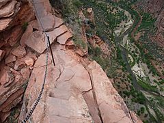
The last half-mile of the trail is very tough. It has many sharp drop-offs and narrow paths. To help hikers, chains are placed along parts of this section. You can hold onto these chains to help you climb safely to the top, which is at 5,790 feet (1,760 m).
This challenging half-mile section, known as the Angels Landing Trail-West Rim Trail, was recognized for its special design in 1987. It was added to the National Register of Historic Places.
Safety and Permits
Hiking Angels Landing is an exciting adventure, but it's important to be safe. Since 2022, you need a special permit to go beyond Scout Lookout to the summit. This permit system was put in place because the trail became too crowded. It helps make the experience better for everyone, protects the park, and makes the hike safer. You can get permits from the National Park Service through a lottery system or by applying the day before your hike.
In July 2018, the trail had to close for a short time because of damage from a big storm. It reopened a couple of months later in September 2018.
Weather at Angels Landing
The best times to visit Angels Landing are during spring and fall. The area has a cold semi-arid climate. This means it gets less than 10 inches (250 millimeters) of rain each year. Snowfall in winter is usually light.
Climbing Routes
Besides the main hiking trail, there are also more challenging climbing routes on Angels Landing for experienced climbers. Some of these routes include:
- Prodigal Son – 9 pitches
- Lowe Route – 13 pitches
- Northeast Buttress – 8 pitches
- South Face – 3 pitches
- Ball and Chain – 9 pitches
- Angels Hair – 11 pitches
Gallery
-
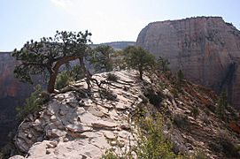
The very top of Angels Landing -
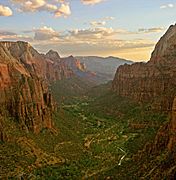
Zion Canyon as seen from the top of Angels Landing -
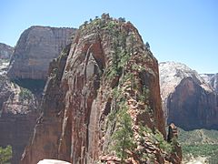
Looking towards the highest point of Angels Landing
-
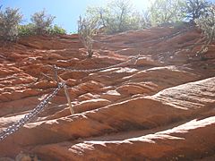
The Angels Landing trail with its helpful chain cables
-
A view of Zion Canyon from Angels Landing, showing how tall the cliffs are


See also
