
Historical buildings and structures of Zion National Park facts for kids
Quick facts for kids |
|
|
Multiple Resources for Zion National Park
|
|

East Entrance Sign
|
|

Location in Utah

Location in the United States
|
|
| Architectural style | NPS-Rustic style |
|---|---|
| MPS | Zion National Park MRA |
| NRHP reference No. | 64000878 |
The historical buildings and structures of Zion National Park are a collection of old buildings, signs, and other structures. They are all part of how the National Park Service runs Zion National Park in Utah. These structures come in many sizes, from the large Zion Lodge to small road curbs. Almost all of them were built using local materials and special building methods. This style is called the National Park Service Rustic style.
Many of the bigger buildings were designed by Gilbert Stanley Underwood. Smaller structures were planned by the National Park Service's design team. Most of these historic buildings were built in the 1920s and 1930s. A lot of the work in the 1930s was done by the Civilian Conservation Corps, a group that helped people find jobs during the Great Depression.
The "National Park Service Rustic" style used in Zion was a bit different from other parks. For example, the Zion Park Lodge used smaller pieces of wood and stone. It also used smooth, cut lumber instead of rough logs. This was because the Zion area already had farms and irrigation systems.
Many of Zion's historic structures are listed on the National Register of Historic Places (NRHP). This means they are important and protected. They all look very similar, sharing design, size, and materials. People say they are some of the best examples of the National Park Service Rustic style.
The park also keeps parts of early Mormon settlements from 1862. You can still see two old irrigation canals and a cable system used for moving timber.
Contents
Historic Buildings of Zion National Park
Utah Parks Company: Visitor Buildings
- The Zion Lodge was designed in 1924 by Gilbert Stanley Underwood. It was the main building for visitors in Zion. A fire destroyed it in 1966. A new lodge was built in 1992 to look more like Underwood's original design.
- The Zion Lodge Historic District is a group of old buildings around the Zion Lodge. Most of these were also designed by Underwood. This area is listed on the National Register of Historic Places.
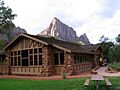
- The Zion Nature Center-Zion Inn was built in 1934. It was first used as a cafeteria, gift shop, and office for tourist cabins. It was also designed by Underwood in the National Park Service Rustic style. The Park Service changed it into a nature center in 1972. The building has strong stone pillars at its corners. Its roof is made of logs. The Zion Inn was listed on the National Register of Historic Places in 1987. It has recently been fixed up to look like Underwood's first design. 37°12′19.2″N 112°58′56.75″W / 37.205333°N 112.9824306°W
Roads and Transportation
- The Floor of the Valley Road follows the North Fork of the Virgin River through Zion Canyon. This nine-mile road was designed to fit into the landscape. It also helps visitors see the canyon's amazing features. The first parts were built in 1916. Most of the road and its structures were built in the 1930s. This was a public works project during the Great Depression.

- The Cable Creek Bridge is on the Floor of the Valley Road. It is listed on the National Register of Historic Places. This is because it is a great example of the National Park Service Rustic style. The bridge is made of concrete covered with sandstone. It was designed by the National Park Service and built in 1932. Civilian Conservation Corps workers helped build it. 37°16′13″N 112°56′19″W / 37.27028°N 112.93861°W
- The Zion-Mount Carmel Highway was built to connect Zion with Grand Canyon National Park. It was finished in 1930. The road has a long tunnel, 5,613-foot (1,711 m) long, through Pine Creek Canyon. This road lets visitors drive a loop tour of Grand Canyon, Zion, Bryce Canyon National Park, and Cedar Breaks National Monument.
- The East Entrance Checking Station was built in 1935. Civilian Conservation Corps workers from Camp NP-2 built it. It is at the eastern end of the Zion-Mt. Carmel Highway. The station was designed by the National Park Service. It uses the National Park Service Rustic style with rough sandstone walls. It was listed on the National Register of Historic Places in 1987. 37°13′59.7″N 112°52′31.5″W / 37.233250°N 112.875417°W

- The East and South Entrance Signs are also listed on the National Register of Historic Places. These signs have two tall red sandstone pillars. A log sticks out from one pillar, holding the sign. The National Park Service designed them in 1936. Civilian Conservation Corps workers built them. They were changed a bit in 1940. The signs show a design that was used for many park structures in Zion. 37°14′7″N 112°52′7″W / 37.23528°N 112.86861°W (east) and 37°12′4.7″N 112°59′18.8″W / 37.201306°N 112.988556°W (south).
Park Service Facilities
- The Grotto Camping Ground Comfort Stations were built like the Grotto Residence. The south station was built in 1925. The north station was built in 1930-31. They have large stone walls and wide roof overhangs. Both were updated in 1959. They are listed on the National Register of Historic Places. 37°15′31″N 112°56′27″W / 37.25861°N 112.94083°W (south) and 37°15′33″N 112°56′33″W / 37.25917°N 112.94250°W (north).
- The South Campground Comfort Station was designed in 1934. It used the rustic design elements of older buildings. This building was listed on the NRHP in 1987. 37°12′14″N 112°58′21″W / 37.20389°N 112.97250°W
- The South Campground Amphitheater was built by the Civilian Conservation Corps in 1934 and 1935. You can see their work in the stone stage, walls, walkways, and steps. Red sandstone was used to match the park's rustic style. The original wooden benches were replaced with metal seats in 1956. The amphitheater was listed on the National Register of Historic Places in 1987. 37°12′15.9″N 112°58′52.2″W / 37.204417°N 112.981167°W
Employee and Service Buildings
.jpg)
- The Museum-Grotto Residence is the oldest building still standing in Zion National Park. It was built in 1924 as the Park Museum. It was then changed into a home in 1936. Civilian Conservation Corps workers helped with this. The stonework here is much bigger than in later buildings. The Grotto Residence was listed on the National Register of Historic Places in 1987. 37°15′28″N 112°57′3″W / 37.25778°N 112.95083°W

- The East Entrance Residence is next to the East Entrance Checking Station. Civilian Conservation Corps workers built this home in 1934. It was designed in the National Park Service Rustic style. It is listed on the National Register of Historic Places. 37°13′59.7″N 112°52′35.7″W / 37.233250°N 112.876583°W
- The Pine Creek Residential Historic District was designed to house Park Service staff. It set the style for smaller buildings in Zion. The five main buildings were built in 1929-1930. They used red sandstone, cedar shingles, and cut lumber. This area includes the Superintendent's (park manager's) home. The Pine Creek district was listed on the National Register in 1987. 37°12′59″N 112°58′32″W / 37.21639°N 112.97556°W
- The buildings of the Oak Creek Historic District were built in the 1930s and early 1940s. They followed the standard National Park Service Rustic style used at Zion. The Oak Creek area provided homes for park employees. It also had service and utility buildings. Most were built by Civilian Conservation Corps workers. This district was listed on the National Register of Historic Places in 1987. 37°12′40″N 112°59′10″W / 37.21111°N 112.98611°W
Historic Trails
- The Canyon Overlook Trail was built by Civilian Conservation Corps workers in 1933. It goes from the east side of the Zion-Mt. Carmel Tunnel to a viewpoint of the Great Arch. Local park officials made sure its design matched other trails in Zion. The trail was listed on the National Register in 1987. 37°12′49″N 112°56′54″W / 37.21361°N 112.94833°W
- The East Rim Trail is 4 miles (6.4 km) long. A local rancher named John Winder improved it in 1896. It was originally an Indian trail. The National Park Service improved it further in 1918-1919. The lower part of the trail led to the Cable Mountain Draw Works. The trail has stone walls that are common in Zion's park improvements. The East Rim Trail was listed on the National Register of Historic Places in 1987. 37°16′42″N 112°55′45″W / 37.27833°N 112.92917°W
.jpg)
- The Angels Landing Trail-West Rim Trail was built in 1926. The Angels Landing trail climbs a steep sandstone ridge. It has rails and chains to help climbers on a 300-foot (91 m) climb in .5 miles (0.80 km). It connects to the West Rim Trail, which was built in 1925-26 and made longer in 1935. Both trails were planned by Thomas Chalmers Vint and Walter Ruesch. Walter Ruesch gave his name to "Walter's Wiggles," which are 21 switchbacks (sharp turns). These trails were listed on the National Register of Historic Places in 1987. 37°16′6″N 112°56′58″W / 37.26833°N 112.94944°W
- The Emerald Pools Trail starts at the Zion Lodge and goes west to Lower Emerald Pool. It was built in 1932 using only hand tools. An extension built the same year goes to the Grotto Campground. The first part of the trail needed well-built stone steps. Repairs to the stonework were done in 1969. The 2.2-mile (3.5 km) trail was listed on the National Register of Historic Places in 1987. 37°14′58″N 112°57′16″W / 37.24944°N 112.95444°W
- The Gateway to the Narrows Trail, also called the Riverside Walk, is a short, one-mile nature trail along the Virgin River. It connects the parking area at the Temple of Sinawava to The Narrows. This trail is listed on the National Register of Historic Places. It uses local materials like red sandstone to blend in with nature, following the National Park Service Rustic style. Construction began in 1929. In 1968, a rock slide covered part of the trail. Instead of removing the rocks, the trail was rerouted over the slide. The trail was made easier for people with disabilities in 1982. The trail was listed on the National Register of Historic Places in 1987. 37°17′48″N 112°56′42″W / 37.29667°N 112.94500°W
- The Grotto Trail starts at Zion Lodge. It runs along the valley floor to the Zion Museum, which is now the Grotto Picnic Area. This trail was designed by Harry Langley and built by the National Park Service in 1932. Only hand tools were used. Stone walls and culverts (tunnels for water) were built to keep the rustic style. The Grotto Trail was listed on the National Register of Historic Places in 1986. 37°15′1″N 112°57′26″W / 37.25028°N 112.95722°W

- The Hidden Canyon Trail was built in 1928 to reach a hanging canyon. The trail has three parts. The first part is a horse trail with eleven switchbacks (sharp turns) and stone walls. The next 745-foot (227 m) section is for hikers only, along a natural shelf. It has a small blasted passage with steps and a handrail. The last part was blasted from a steep slope by workers hanging from ropes. The trail was designed to blend into the landscape. Plants were protected during construction. The Hidden Canyon Trail was listed on the National Register of Historic Places in 1987. 37°16′1″N 112°55′50″W / 37.26694°N 112.93056°W
Other Historic Places
- The Cable Mountain Draw Works was built by David Flanigan starting in 1901. It was used to move timber (wood) from the top of Cable Mountain down to the valley. This was a 2,000 feet (610 m) drop! Before this system, getting timber from Cable Mountain took ten days. The system was damaged by lightning and rebuilt in 1911. It was used until 1926 and then abandoned. The cables were removed in 1930. This is the oldest structure in Zion from before it became a park. It was listed on the National Register of Historic Places in 1978. 37°15′57″N 112°55′59″W / 37.26583°N 112.93306°W
- The main part left is a wooden structure on Cable Mountain. Nothing remains of the bottom part of the system.
- The Pine Creek Irrigation Canal was dug around the 1890s by Mormon farmers. They used water from Pine Creek to water their farms. Original rock walls can still be seen. New parts were built in 1934 by Civilian Conservation Corps workers. This canal was listed on the National Register of Historic Places in 1987. 37°12′6″N 112°58′40″W / 37.20167°N 112.97778°W
- The Oak Creek Irrigation Canal was built in 1935 by Civilian Conservation Corps workers. It was used to water plants in the park's South Campground. More improvements were made in 1941. The canal is about 2-mile (3.2 km) long. It takes water from the North Fork of the Virgin River. The canal was listed on the National Register of Historic Places in 1987. 37°12′9″N 112°59′28″W / 37.20250°N 112.99111°W
- Flanigan Ditch was built around 1880 by the Flanigan family, who were early settlers in Zion valley. They used water from the Virgin River to water their land. The family was important in the area. The famous rock formation "The Watchman" was once called "Flanigan Peak." Part of the ditch still carries water to water the Watchman campground. Flanigan Ditch was listed on the NRHP in 1998. 37°12′53″N 112°58′28″W / 37.21472°N 112.97444°W
Images for kids
-
Zion Nature Center - Zion Inn

