
North Hartland, Vermont facts for kids
Quick facts for kids
North Hartland, Vermont
|
|
|---|---|

Willard Covered Bridge
|
|

Location in Windsor County and the state of Vermont.
|
|
| Country | United States |
| State | Vermont |
| County | Windsor |
| Area | |
| • Total | 1.0 sq mi (2.7 km2) |
| • Land | 1.0 sq mi (2.6 km2) |
| • Water | 0.04 sq mi (0.1 km2) |
| Elevation | 370 ft (110 m) |
| Population
(2010)
|
|
| • Total | 302 |
| • Density | 290/sq mi (111.9/km2) |
| Time zone | UTC-5 (Eastern (EST)) |
| • Summer (DST) | UTC-4 (EDT) |
| ZIP code |
05052
|
| Area code(s) | 802 |
| FIPS code | 50-50500 |
| GNIS feature ID | 1458736 |
North Hartland is a small community in Vermont, United States. It's located in Windsor County, within the larger town of Hartland. In 2010, about 302 people lived here. It's known as a census-designated place (CDP), which means it's a specific area identified by the U.S. Census Bureau for statistical purposes.
Contents
Exploring North Hartland's Location
North Hartland is found in the eastern part of Windsor County. It sits where two rivers meet: the Ottauquechee River and the larger Connecticut River.
Roads and Travel in North Hartland
U.S. Route 5 goes right through the village. This road connects North Hartland to White River Junction to the north. To the south, it leads to Hartland and Windsor.
Interstate 91 also passes close by, just north of the village. However, there isn't a direct exit or entrance to Interstate 91 from North Hartland itself.
Images for kids
-
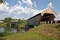
Willard Covered Bridge
-
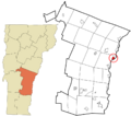
Location of North Hartland in Windsor County, Vermont
See also
 In Spanish: North Hartland para niños
