North Philipsburg, Pennsylvania facts for kids
Quick facts for kids
North Philipsburg, Pennsylvania
|
|
|---|---|

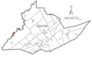
Location within Centre County
|
|
| Country | United States |
| State | Pennsylvania |
| County | Centre |
| Township | Rush |
| Area | |
| • Total | 0.74 sq mi (1.91 km2) |
| • Land | 0.74 sq mi (1.91 km2) |
| • Water | 0.00 sq mi (0.00 km2) |
| Elevation | 1,470 ft (450 m) |
| Population
(2020)
|
|
| • Total | 617 |
| • Density | 836.04/sq mi (322.73/km2) |
| Time zone | UTC-5 (Eastern (EST)) |
| • Summer (DST) | UTC-4 (EDT) |
| ZIP code |
16866
|
| Area code(s) | 814 |
| FIPS code | 42-55304 |
| GNIS code | 1182620 |
North Philipsburg is a small community in Centre County, Pennsylvania, United States. It's known as a census-designated place (CDP). This means it's an area that the U.S. Census Bureau defines for gathering population data. North Philipsburg is part of the bigger State College, Pennsylvania area. In 2010, about 660 people lived here.
Contents
Geography of North Philipsburg
North Philipsburg is located in the western part of Centre County. Its exact location is 40°54′26″N 78°12′32″W / 40.90722°N 78.20889°W. It sits next to the town of Philipsburg to the southwest. To the northwest, it borders Moshannon Creek. This creek forms the boundary with Clearfield County. The creek flows north and eventually joins the West Branch Susquehanna River.
Roads and Travel
U.S. Route 322 passes just south of North Philipsburg. This road can take you about 11 miles (18 km) southeast to Interstate 99 at Port Matilda. If you go northwest on Route 322, it's about 17 miles (27 km) to Clearfield. Interstate 80 is also nearby, about 8 miles (13 km) north, accessible via Pennsylvania Route 53. Another road, PA 504, goes east from North Philipsburg for about 8 miles (13 km) to Black Moshannon State Park.
Land Area
The United States Census Bureau reports that North Philipsburg covers a total area of about 0.74 square miles (1.96 square kilometers). All of this area is land, with no water.
People of North Philipsburg
The population of North Philipsburg changes over time.
| Historical population | |||
|---|---|---|---|
| Census | Pop. | %± | |
| 2020 | 617 | — | |
| U.S. Decennial Census | |||
In 2010, there were 660 people living in North Philipsburg. These people lived in 263 households, and 140 of these were families. The area had about 899.7 people per square mile (347.4 people per square kilometer). There were also 286 housing units, which are homes or apartments.
Population Details
Most people in North Philipsburg are White (98.2%). A small number of people are Native American (0.1%), Asian (0.2%), or from other backgrounds. About 0.5% of the population identified as Hispanic or Latino.
Households and Families
About 21.3% of households had children under 18 living with them. Many households (40.7%) were married couples living together. Some households had a male head (5.3%) or a female head (7.2%) without a spouse. About 46.8% of households were not families. Many people (41.4%) lived alone, and 23.2% of households had someone aged 65 or older living by themselves. On average, there were 2.10 people per household and 2.88 people per family.
Age Groups
The population in North Philipsburg is spread out across different age groups. About 14.2% of the people were under 18 years old. About 6.8% were between 18 and 24. People aged 25 to 44 made up 21.4% of the population. Those aged 45 to 64 were 22.1%. A large portion, 35.5%, were 65 years or older. The average age in North Philipsburg was 52 years. For every 100 females, there were about 76.9 males.
Income Information
In 2010, the average income for a household in North Philipsburg was about $36,598 per year. For families, the average income was around $37,257. The per capita income, which is the average income per person, was $16,432. About 10.5% of all people in North Philipsburg lived below the poverty line. This included 5.9% of those aged 65 or older.
See also
 In Spanish: North Philipsburg para niños


