Norwalk Harbor facts for kids
Quick facts for kids Norwalk Harbor |
|
|---|---|
| Location | |
| Country | United States |
| Location | Norwalk, Connecticut |
| Coordinates | 41°05′24″N 73°24′21″W / 41.0900968°N 73.4059520°W |
| Details | |
| Type of harbor | recreational and small commercial |
| Available berths | 1800 berths, 500+ moorings (small craft) |
| Wharfs | 5 |
| Harbor master | Michael Griffin |
| Statistics | |
| Annual cargo tonnage | 512,000 short tons (in 2001) |
| Website http://www.norwalkct.org/HarborComm/index.htm |
|
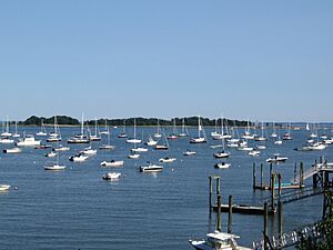
Norwalk Harbor is a busy place in Norwalk, Connecticut, where the Norwalk River meets the Long Island Sound. It's used for both fun activities like boating and for moving goods.
This harbor is actually the end part of the Norwalk River, from Wall Street all the way to the Long Island Sound. It's a special waterway managed by the government for boats of all sizes, especially smaller ones.
Around the harbor, you'll find many places for boats. There are 15 marinas and 13 private clubs with boating areas. There are also 5 places where commercial ships can dock. In total, there are over 1,800 spots for boats to tie up and more than 500 places to moor (anchor). About 800 boats can be launched from storage racks or from the public ramp at Veterans Park.
Each year, more than 2,700 commercial boats travel in and out of the harbor. The main channel is not huge, so it limits the size of ships that can use it. In 2001, about 512,000 short tons of goods were moved through the harbor. These goods often included fuel oil, sand, gravel, stone, and seafood like oysters and lobsters.
Contents
Exploring Norwalk Harbor
When you approach Norwalk Harbor from the Long Island Sound, the main way in is southwest of Rowayton and Sheffield Island. This wider and deeper path is called "Sheffield Harbor." There's also a narrower, shallower way called "Cockenoe Harbor" to the east.
The main channel that runs through the harbor is about 4.7 miles (7.6 km) long. It starts from the outer harbor and goes all the way to the end of the harbor in Norwalk.
Harbor Channel Details
- The channel is 12 feet (3.7 m) deep and 200 feet (61 m) wide from the outer harbor to Gregory Point.
- Near Gregory Point, it gets a bit narrower, becoming 150 feet (46 m) wide up to the docks in South Norwalk.
- It then widens to 250 feet (76 m) along the docks to the Washington Street (Stroffolino) Bridge.
- Beyond this bridge, the inner harbor continues for about 1.5 miles (2.4 km).
- The inner harbor channel is 10 feet (3.0 m) deep and 100 to 200 feet (30 to 61 m) wide. It ends at the Wall Street bridge in central Norwalk.
- There's also a 10-foot (3.0 m) deep area for boats to anchor, covering about 17 acres (6.9 ha), on the east side near Fitch Point.
- Another 0.6-mile (1.0 km) long channel, 6 feet (1.8 m) deep and 125 to 150 feet (38 to 46 m) wide, extends northeast from the anchorage to the end of the harbor at East Norwalk.
Bridges Over the Inner Harbor
As you travel from Wall Street towards the outer harbor, you'll go under several bridges:
- Wall Street Bridge: An arch bridge in Central Norwalk.
- Yankee Doodle Bridge: A girder bridge that carries the Connecticut Turnpike.
- Norwalk River Railroad Bridge: A four-track swing bridge used by Amtrak and the Metro-North Railroad.
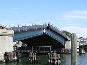
- Washington Street (Stroffolino Memorial) Bridge: A bascule bridge that carries Route 136. This bridge can lift up to let taller boats pass.
There are no bridges across the outer harbor or its main entry paths.
History of Norwalk Harbor
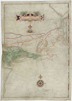
In 1614, a Dutch explorer named Adriaen Block sailed along the Connecticut coast. He mapped the Norwalk Islands, which are at the edge of the harbor, and called them the "Archipelago."
To help ships navigate safely, the Sheffield Island Light was built and started working by 1826. The United States Army Corps of Engineers began improving the harbor in 1872. In 1897, the U.S. Congress approved money for more navigation aids. This led to the Greens Ledge Light starting in 1902 and the Pecks Ledge Light in 1906. Once Greens Ledge Light was active, the Sheffield Island Light was no longer needed by the government.
Two old yacht clubs are located along Norwalk Harbor:
- The Ischoda Yacht Club was founded in 1886 on the western shore.
- The Norwalk Yacht Club was formed in 1894 in Wilson's Cove.
The U.S. Army Corps of Engineers has dredged (cleaned out the bottom) the harbor several times, including in 1950, 1980, and 2006. There are plans for new dredging projects in the inner and river parts of the harbor.
Major Events and Changes
In October 1955, a huge flood swept down the Norwalk River. It destroyed many buildings along the riverbanks and caused a lot of damage in the harbor. It took a long time for the area to recover.
The Connecticut Turnpike was built over the river between 1956 and 1958. A salt marsh near the Yankee Doodle bridge was turned into a garbage dump, but it has since been cleaned up and is now "Oyster Shell Park."
The Norwalk Harbor Commission was created in 1984. This group helps manage the harbor, making sure it's safe for boats, promoting its use, and taking care of the Visitors dock at Veterans Park.
In 2007, the Norwalk Police Department launched a new 38-foot (12 m) police boat called the Riva. The Norwalk Fire Department also got its first fireboat, the Harry Bower, named after a firefighter who passed away. That same year, a very large 228-foot (70 m) motor yacht called the Seafair visited the harbor, showing off its art galleries.
Also in 2007, old electric power cables running under the harbor from Connecticut to Long Island were replaced with new ones. These cables connect an electric power station on Manresa Island in Norwalk Harbor to a substation in Northport, New York. The new 11-mile (18 km) long cables were buried deep under the Sound's bottom.
The Skyline Princess, a 120-foot (37 m) motor yacht from New York, sometimes stops at Veterans Park.
Harbor Geology
Norwalk Harbor is a "drowned river valley." This means it was once a river valley that got flooded when sea levels rose after the last ice age. The rocks under the harbor and in nearby areas are a mix of different types of gneisses. These rocks contain dark minerals like hornblende, biotite, and garnet.
The bedrock in the harbor area has two major folds. The older fold runs from Bell Island through Manresa Island to Sprite Island. The second fold runs north from Noroton Point on Sheffield Island Harbor towards Exit 15 on Interstate 95.
 | DeHart Hubbard |
 | Wilma Rudolph |
 | Jesse Owens |
 | Jackie Joyner-Kersee |
 | Major Taylor |


