Norwalk Islands facts for kids

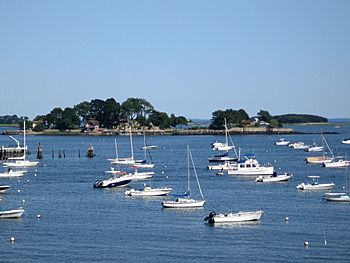
Tavern Island, with Ram Island behind it to the right
|
|
| Geography | |
|---|---|
| Location | Norwalk and Westport |
| Coordinates | 41°3′54″N 73°23′24″W / 41.06500°N 73.39000°W |
| Archipelago | Norwalk Islands |
| Total islands | 25+ |
| Major islands | Chimon, Cockenoe, Shea, Sheffield |
| Administration | |
|
United States
|
|
| State | Connecticut |
| Demographics | |
| Population | 0 |
| Pop. density | 0 /sq mi (0 /km2) |
The Norwalk Islands are a group of more than 25 islands. They are found in Long Island Sound, off the coast of Norwalk, Connecticut and southwest Westport, Connecticut. These islands stretch for about 6 miles (10 km) and are usually about a mile from the mainland. You'll also see partly hidden rocks, reefs, and muddy areas around them.
People use the islands for many fun activities. These include camping, boating, kayaking, swimming, and watching birds. The islands are owned by different groups. Some are private, some belong to the towns of Norwalk or Westport, and some are part of the Stewart B. McKinney National Wildlife Refuge.
Laws help protect these islands and their wildlife. On a clear day, you can even see the tall buildings of Manhattan from here!
Contents
How the Islands Were Formed
Scientists believe the Norwalk Islands were made about 17,500 years ago. They are thought to be terminal moraines. This means they are piles of rocks, gravel, sand, and clay left behind by huge sheets of ice called glaciers. As the glaciers slowly melted and moved north, they dropped these materials.
The islands in Greenwich to the west are part of the same moraine. There are also parts of this moraine hidden underwater between the Norwalk Islands and Charles Island, near Milford.
Some historians think that rocks from these islands were used as ballast on old sailing ships. Ballast is heavy material that helps keep a ship stable. These rocks might have been used to make cobblestone streets in New York City.
Fun Things to Do on the Islands
There is no fresh water available on any of the islands. So, if you visit, remember to bring your own!
Kayaking Adventures
The Norwalk Islands are a popular spot for kayakers. Some people even paddle all the way from New York City! The water currents are usually gentle, and you can always see the mainland. An electric power plant on Manresa Island can help you find your way.
You can find public boat launches and beaches nearby. Some businesses in Norwalk also rent kayaks. A special map called the "Norwalk Islands Canoe and Kayak Trail" shows different routes for full-day or half-day trips. You can also join guided kayak tours.
Fishing, Clamming, and Hunting
Many types of fish can be caught near the islands. These include striped bass, bluefish, fluke, and flounder. Some areas are even used to grow clams.
During duck-hunting season, hunters can hunt below the high-tide line. If you have permission from the owner, you can also hunt deer on privately owned islands.
Bird Watching
Many years ago, lots of birds nested on different islands. Now, most of the bird nesting areas, called rookeries, are on Cockenoe Island. You can see herons, egrets, and black cormorants there.
Animals and Plants of the Islands
Deer are known to swim to the islands. You might also see harbor seals, especially near the southwest end of Sheffield Island. It's important to stay at least 50 yards (46 m) away from seals so you don't disturb them. Laws like the Marine Mammal Protection Act help protect these animals.
The islands are home to various plants. You can find thorny bushes, wild blackberries, black cherry trees, and honeysuckle.
Sheffield Island used to have many birds, but now Cockenoe Island is the biggest home for them. Sheffield Island still has good spots for birds like osprey, herons, and other birds that travel long distances. Many wading birds, shore birds, songbirds, and terns live here, including the roseate tern. You can also spot Brant geese, scoters, and black ducks in the waters around the islands.
The Biggest Islands
Chimon Island
Chimon Island is the largest of the Norwalk Islands, covering about 59 acres (24 ha). It's located in the middle of the island group, less than a mile southeast of the entrance to Norwalk Harbor. This island is part of the Stewart B. McKinney National Wildlife Refuge.
The north and west sides of the island have gravelly beaches. The south and east sides have many rocks and boulders. You can land your boat at the 3-acre (1.2 ha) beach on the northwest shore during the day, all year round. However, most of the island is closed from April 1 to August 15. This is to protect birds during their nesting season. You cannot camp overnight on Chimon Island. Chimon Island is at 41°03′54″N 73°23′24″W / 41.065°N 73.39°W.
Cockenoe Island
Cockenoe Island (pronounced "koh-KEE-nee" or "kuh-KEE-nee") is owned by the Westport town government. It has almost all the bird nesting areas in the island chain. You can see herons, egrets, and black cormorants here. The cormorants' droppings, called guano, can make some rocks white. This guano is also harmful to trees, causing them to die after the birds nest in a spot for a short time.
Overnight camping is allowed by the town's Conservation Department. However, only four groups can camp each night. Cockenoe Island is at 41°05′06″N 73°21′18″W / 41.085°N 73.355°W. The island is named after Cockenoe, a famous Native American translator.
Island History
There was an old story that the pirate William Kidd buried treasure on Cockenoe Island. In the 1800s, the island was a working farm with a farmhouse, barn, and animals. Later, it became a whisky distillery. The government raided this distillery in 1870.
In the 1960s, a company planned to build a nuclear power plant on Cockenoe. But local residents were worried. To protect the island, Westport bought it for $200,000 in 1967.
Shea Island
Shea Island was once called "Ram Island." It was renamed after Daniel J. Shea, a hero from Norwalk who received the Congressional Medal of Honor for his bravery in the Vietnam War. This 45-acre (18 ha) island is owned by the city of Norwalk. It is just northeast of Sheffield Island.
Shea Island, along with Grassy Island, is open to the public from May until Columbus Day. Campers with a permit can stay overnight. There are two restrooms powered by the sun, and 16 campsites. The shoreline is covered with rocks and boulders, making it a bit tricky to land a boat. Shea Island is at 41°03′34″N 73°24′07″W / 41.0595°N 73.402°W.
Sheffield Island
Sheffield Island is the second largest island in the group, at 51 acres (21 ha). It's also the most southerly island, about 1,500 yards (1,400 m) from the Norwalk coast. The entire shoreline is rocky.
Many bird species nest on Sheffield Island. It's also one of the best places to see seals. The Maritime Aquarium at Norwalk offers boat trips around the islands. They have special cruises to see fall leaves and winter cruises to spot harbor seals and waterfowl.
Sheffield Island is part of the Stewart B. McKinney National Wildlife Refuge. The U.S. Fish and Wildlife Service manages it. Most of the island is closed to the public for much of the year to protect bird nesting areas. However, a 3.5-acre (1.4 ha) area around the Sheffield Island Light is usually open. The Norwalk Seaport Association takes care of the lighthouse. They have also created a 2,000-yard (1,800 m) trail for visitors. In the summer, the association offers tours to the lighthouse where you can have a picnic. They also host clambakes on Thursday nights and sunset cruises on Friday nights. The lighthouse was built in 1868 and helped guide ships until about 1900. Sheffield Island is at 41°03′07″N 73°24′54″W / 41.052°N 73.415°W.
Other Islands in the Group
Here are some of the other islands you can find in the Norwalk Islands chain:
- Betts Island — This island is about 400 yards (370 m) north of Chimon Island and is privately owned. Betts Island is at 41°04′19″N 73°23′20″W / 41.072°N 73.389°W.
- Calf Pasture Island — Located almost 1,000 yards (910 m) southeast of Calf Pasture Beach. Calf Pasture Island is at 41°04′57″N 73°23′02″W / 41.0825°N 73.384°W.
- Copps Island — You can find this island close to the southeast end of Crow Island. Copps Island is at 41°03′32″N 73°23′13″W / 41.0589°N 73.387°W.
- Crow Island — This island is about 300 yards (270 m) southeast of Chimon Island. Crow Island is at 41°03′40″N 73°23′26″W / 41.061°N 73.3905°W.
- Grassy Island — Located 300 yards (270 m) northeast of Chimon Island. Norwalk city government owns it. Grassy Island has a better spot for boats to land than Shea Island. It's open to the public from May through Columbus Day. Campers with permits can stay overnight at one of the four campsites. Grassy Island is at 41°04′16″N 73°22′55″W / 41.071°N 73.382°W.
- Goose Island — About 1,000 yards (910 m) east of Grassy Island. Some people say scientists did research here to find a cure for yellow fever. Others believe a small stone hut on its shore was a spy lookout during World War II. Goose Island is at 41°04′16″N 73°22′19″W / 41.071°N 73.372°W.
- Hoyt Island — This island is very close to the coast of Norwalk. Hoyt Island is at 41°04′26″N 73°25′10″W / 41.074°N 73.4195°W.
- Little Tavern Island — About 150 yards (140 m) northeast of Tavern Island. Little Tavern Island is at 41°03′47″N 73°25′12″W / 41.0630°N 73.4201°W.
- Long Island — Located about 300 yards (270 m) east of the southern end of Manressa Island. Long Island is at 41°04′22″N 73°24′12″W / 41.0729°N 73.4034°W.
- Peach Island — About 100 yards (91 m) east of the Harborview neighborhood in South Norwalk. This island is part of the McKinney Wildlife Refuge and is closed to visitors. Peach Island is at 41°04′59″N 73°24′20″W / 41.083°N 73.4055°W.
- Sprite Island — About 300 yards (270 m) northeast of Calf Pasture Beach. In the 1940s, a New York City financier used this island as his summer home. Now, it's home to the Sprite Island Yacht Club, which bought the island in 1952. The former owner raised collies, and the club turned the dog kennels into storage lockers. One end of the island has a rocky cliff, and another has a small, protected rocky beach. You can walk around the whole island in about 20 minutes. Sprite Island is at 41°05′24″N 73°22′52″W / 41.09°N 73.381°W.
- Tavern Island — About 500 yards (460 m) from Wilson Point and 1,000 yards (910 m) north of Sheffield Island. It has a private mansion with gardens and walkways. The famous showman Billy Rose once owned Tavern Island. Tavern Island is at 41°03′38″N 73°25′19″W / 41.0605°N 73.422°W.
- Tree Hammock Island — About 2,000 feet (610 m) south of Manressa Island and 1,000 feet (300 m) north of Shea Island. Tree Hammock Island is at 41°03′54″N 73°24′19″W / 41.0649°N 73.4053°W.
 | Janet Taylor Pickett |
 | Synthia Saint James |
 | Howardena Pindell |
 | Faith Ringgold |


