Nutbrook Canal facts for kids
Quick facts for kids Nutbrook Canal |
|
|---|---|

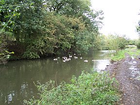
Parts of the canal still have water in 2006
|
|
| Specifications | |
| Maximum boat length | 73 ft 0 in (22.25 m) |
| Maximum boat beam | 14 ft 3 in (4.34 m) |
| Locks | 13 |
| Status | Derelict |
| History | |
| Original owner | Nutbrook Canal Proprietors |
| Principal engineer | Benjamin Outram |
| Date of act | 1793 |
| Date completed | 1796 |
| Date closed | 1949 |
| Geography | |
| Start point | Shipley |
| End point | Trowell |
| Connects to | Erewash Canal |
The Nutbrook Canal was a waterway in England. It stretched from Shipley in Derbyshire to the Erewash Canal, joining it near Trowell. This canal was built to help transport coal from mines in Shipley and West Hallam. It was finished in 1796.
At first, the canal made good money. But after 1846, trains became a big competitor. Even worse, the ground under the canal started to sink. This was caused by the very coal mines the canal was built to serve! The mines stopped paying fees for using the canal. Sometimes, they even refused to fix the sinking ground. Because of these problems, most of the canal closed in 1895. However, the last 1.5 miles (2.4 km) stayed open until 1949.
Contents
Building the Nutbrook Canal
The area where the Nutbrook Canal was built was quite remote. Even though there were coal mines, it was hard to move goods around. A new road built in 1764 helped a little. But it couldn't handle heavy loads, especially in winter.
Things got better when the Erewash Canal was built between 1777 and 1779. Coal from Shipley Colliery reached this canal using a wooden track. The Erewash Canal company offered a discount if the mine owners built a branch canal into the Nutbrook Valley.
Planning the Canal
In 1791, important landowners like Edward Miller Mundy and Sir Henry Hunloke wanted to build a canal. They first tried to do it without a special law from Parliament. But in 1792, they decided to ask Parliament for permission. Landowners objected because they wanted a public company to own it, not just the mine owners.
A famous canal engineer named William Jessop was asked to design the canal. He thought it would cost about £12,542 (which was a lot of money back then!). John Nuttall surveyed the path and made detailed plans. Finally, Parliament approved the canal on June 3, 1793. This law allowed them to raise £13,000, and an extra £6,500 if needed. The canal was not a public company. This allowed the mine owners to get their discount on the Erewash Canal.
How it was Built
Benjamin Outram, an experienced canal builder, became the engineer for the Nutbrook Canal. He had also worked on the Cromford Canal. He managed the workers who built the canal.
The canal was about 4.5 miles (7.2 km) long. It had thirteen locks, which are like water elevators for boats. Each lock was 73 feet (22 m) long and 14.25 feet (4.34 m) wide. The locks helped boats climb a total of 84 feet (26 m) in height. Water for the canal came from Shipley Reservoir, which was fed by the Nut Brook.
The canal opened in stages. The first fees were collected in November 1794. By July 1796, the canal was fully open. Coal from Shipley and West Hallam collieries was being transported. Building the canal cost more than expected. It ended up costing around £22,801 by early 1797. The extra money came from the shareholders, and debts were paid off with early earnings.
Canal Branches
The canal followed the Nut Brook for most of its path. At its southern end, it joined the Erewash Canal. There were two important branches off the main canal. One branch went to Sir Henry Hunloke's estate at West Hallam. Another smaller branch connected to Lord Stanhope's wagonway.
How the Canal Operated
The Nutbrook Canal was never extremely busy. Even in 1821, when it was doing well, only about nine loaded boats used it each day. A big problem was always getting enough water.
Water Supply Issues
When the canal was first built, it got water from a reservoir at Shipley. This reservoir was made by building a dam across the valley. The lake created was pretty for Shipley Hall. But it flooded the road to the hall. So, a new bridge and road had to be built over the dam. The reservoir also got water from a stream above Hawley's Pond.
In 1819, plans were made for a new reservoir above Hawley's Pond. Even after building it, there were still problems with having enough water for the canal.
Canal Fees
The canal charged fees for transporting goods. For coal from Shipley and West Hallam mines, and for all other goods, the fee was 8d per ton. There were lower fees for other coal that didn't transfer to the Erewash Canal. Some fees were also reduced for things like limestone, road stone, and farm materials.
Competition from Railways
In 1832, the Midland Counties Railway planned a new train line. This line would have crossed the Nutbrook Canal. Even though the railway wasn't fully approved, the canal never charged the full 8d fee for coal after that.
In 1846, the Erewash Valley Railway was built. It had branches that went directly to the Shipley Collieries and Stanton iron mines. This directly affected the canal's business. However, by lowering its fees, the canal managed to keep a lot of its traffic.
Problems and Decline
Over the years, the cost of keeping the canal in good shape kept going up.
Sinking Ground
In 1852, the canal company was told that coal would be mined under the dam of the old Shipley reservoir. This would cause the ground to sink. In 1854, there wasn't much rain, and the reservoirs dried up. They spent money to build a small reservoir and raise the banks of the old ones.
More problems came from water leaking out of the canal. This was called seepage. In 1866, they tried to fix a leak at Limekiln lock. But it didn't work well. Water from the canal was reportedly leaking into two mines nearby. In 1871, a court ruled against the canal owners. They had to pay a lot of money for repairs and to the mine owners. The canal company thought about closing the canal. Instead, they closed it for a short time in 1871 for repairs. After that, traffic improved for a bit.
More Railways and Failed Sale
More railways were built, crossing the canal in many places. By 1880, there were seven railway bridges over the canal. In 1876, the canal company tried to sell itself to the Great Northern Railway. But the railway company said no.
The Canal's End
The canal continued to get worse. The ground kept sinking at Shipley and under the West Hallam reservoir in 1879. Traffic often stopped because there wasn't enough water. By 1888, the canal was barely making enough money to cover its costs. They carried 35,000 tons of goods, earning £440. But maintenance alone cost £639.
The company got legal advice. They were told to sue the coal mines. The mines had been taking coal from under the canal and reservoirs. This coal actually belonged to the canal company. So, they sued the West Hallam, Ilkeston, and Manners collieries. Shipley colliery was not sued because they usually paid for damage they caused.
By 1894, the canal's income had dropped to £285. A plan was made to close the company because it was losing too much money. Shipley colliery didn't want to rely only on trains. So, they rebuilt a railway from their mine to Shipley Gate on the Erewash Canal. This railway was used until 1946.
Final Closure
In June 1895, the canal company told the collieries that the locks above Stanton would be closed. This was because the collieries owed a lot of money for rent. The company tried to get a law passed in 1896 to officially abandon the canal. But many groups, including other canals and local councils, opposed this. The canal company decided to drop the plan to avoid more debt.
A 12-inch (30 cm) pipe was laid under the towpath to bypass the middle section of the canal. This ensured that Stanton Ironworks still got water. No more repairs were done to the canal.
In 1907, the company reported that the canal was abandoned. Only 1.3 miles (2.1 km) were "kept open for Stanton." The Stanton Ironworks continued to use the bottom section of the canal. They transported finished iron products. Boats were loaded just above the second lock. The amount of goods leaving by boat slowly went down.
During the Second World War, traffic on this part of the canal increased. It helped with the war effort. Goods like slag for building airfields and bomb cases were carried. Stanton Ironworks sold all their boats in July 1947. Some traffic continued until March 1949, when the last boat used the canal. Between 1940 and its final closure, 59,411 tons of goods were carried on this short stretch.
In 1946, the Stanton Company bought the southern part of the canal from Shipley Collieries. This was to protect its water supply. The Stanton Company still owns this part of the canal today.
What Remains Today
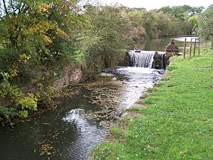
A part of the canal above lock 3 still has water. The lock gates are gone and replaced by small dams called weirs. Beyond this, footpaths follow the old canal path to Hallam wharf. Below lock 3, much of the canal has been filled in as the ironworks expanded. But a pipe in the canal bed still carries water to the works.
The four-story toll house at Ladywood Road bridge was there until 1965. It was torn down by the local council. Mapperley reservoir and Hawley's Pond are still there. Shipley reservoir was changed into a lake for The American Adventure Theme Park, which closed in 2007.
Two original bridges from the reservoir are still standing. Colliery Road Bridge is a single-arched bridge made of sandstone and red brick. It is a grade II listed structure. Paul's Arm Bridge is similar but has two arches.
The Great Northern Railway branch crossed the canal within the Stanton Ironworks. The bridge was damaged during a bombing raid by German airships in 1916, during World War One.
Part of the abandoned canal is now used for fishing. The Stanton Fishing Club manages a section of the canal on Quarry Hill road in Ilkeston.
| Point | Coordinates (Links to map resources) |
OS Grid Ref | Notes |
|---|---|---|---|
| Junction | 52°56′46″N 1°17′10″W / 52.946°N 1.286°W | SK481389 | Erewash Canal |
| Stanhope Arm | 52°57′04″N 1°18′43″W / 52.951°N 1.312°W | SK463395 | Jn with main line |
| Hunloke Arm | 52°57′58″N 1°19′34″W / 52.966°N 1.326°W | SK453411 | Jn with main line |
| Hallam Wharf | 52°58′41″N 1°20′02″W / 52.978°N 1.334°W | SK448424 | |
| Shipley Basins | 52°59′20″N 1°20′13″W / 52.989°N 1.337°W | SK445437 | Upper terminus |
| Shipley Old Reservoir | 52°59′31″N 1°20′20″W / 52.992°N 1.339°W | SK444441 | (American Adventure Park lake) |
| Hawley's Pond | 52°59′06″N 1°20′28″W / 52.985°N 1.341°W | SK443432 | |
| Mapperley Reservoir | 52°59′13″N 1°21′14″W / 52.987°N 1.354°W | SK434434 | Dam |
 | Bayard Rustin |
 | Jeannette Carter |
 | Jeremiah A. Brown |


