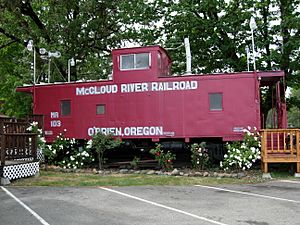
O'Brien, Oregon facts for kids
Quick facts for kids
O'Brien, Oregon
|
|
|---|---|
 |
|
| Country | United States |
| State | Oregon |
| County | Josephine |
| Area | |
| • Total | 5.24 sq mi (13.56 km2) |
| • Land | 5.22 sq mi (13.52 km2) |
| • Water | 0.01 sq mi (0.04 km2) |
| Elevation | 1,415 ft (431 m) |
| Population
(2020)
|
|
| • Total | 470 |
| • Density | 90.02/sq mi (34.75/km2) |
| Time zone | UTC-8 (Pacific (PST)) |
| • Summer (DST) | UTC-7 (PDT) |
| ZIP code |
97534
|
| Area code(s) | 458 and 541 |
| FIPS code | 41-54350 |
| GNIS feature ID | 1147100 |
O'Brien is a small community in Josephine County, Oregon, in the United States. It's called a "census-designated place" (CDP) because it's a recognized area for gathering population data, even though it doesn't have its own city government.
In 2020, about 470 people lived in O'Brien. The community was named after John O'Brien. He was one of the first people to settle in this area.
Contents
Community Life in O'Brien
O'Brien has a few important places for its residents. These businesses are mostly found where Redwood Highway and Lone Mountain Road meet.
You can find Mann's O'Brien Country Store and Discount Gas there. There is also a post office, which uses the ZIP code 97534. The community has a fire station to help keep everyone safe. For food, there's McGrew's restaurant. If you're visiting, the Lone Mountain RV Park offers a place to stay.
South of these main spots, closer to the California border, is the Almost Heaven Member's Resort. O'Brien is the southernmost community in Josephine County.
Where is O'Brien Located?
O'Brien is in the southwestern part of Josephine County. It sits in the valley of the West Fork of the Illinois River. This river flows north and eventually joins the Rogue River.
U.S. Route 199 goes right through O'Brien. If you drive north on this road, you'll reach Cave Junction in about 7 miles. Go further north (about 36 miles total), and you'll get to Grants Pass. If you head south on Route 199, you'll cross into California in about 5 miles. From there, it's about 45 miles to Crescent City, California.
The total area of O'Brien is about 5.24 square miles (13.54 square kilometers). Most of this area is land, with only a tiny bit (about 0.01 square miles or 0.04 square kilometers) being water.
O'Brien's Population Changes
| Historical population | |||
|---|---|---|---|
| Census | Pop. | %± | |
| 2020 | 470 | — | |
| U.S. Decennial Census | |||
The population of O'Brien has changed over the years. In 2010, there were 504 people living there. By 2020, the population was 470. This information comes from the official U.S. Census.
Weather in O'Brien
O'Brien has a Mediterranean climate. This means it has hot and dry summers, and cool and wet winters. It's also considered subtropical because of its very hot summer days. Temperatures often go above 95°F (35°C) in the summer. Even though the summer days are hot, the nights are much cooler.
| Climate data for O'Brien, Oregon | |||||||||||||
|---|---|---|---|---|---|---|---|---|---|---|---|---|---|
| Month | Jan | Feb | Mar | Apr | May | Jun | Jul | Aug | Sep | Oct | Nov | Dec | Year |
| Record high °F (°C) | 66 (19) |
76 (24) |
82 (28) |
92 (33) |
99 (37) |
109 (43) |
112 (44) |
110 (43) |
110 (43) |
100 (38) |
78 (26) |
69 (21) |
112 (44) |
| Mean daily maximum °F (°C) | 51 (11) |
57 (14) |
62 (17) |
68 (20) |
77 (25) |
85 (29) |
94 (34) |
94 (34) |
88 (31) |
74 (23) |
57 (14) |
50 (10) |
71 (22) |
| Mean daily minimum °F (°C) | 33 (1) |
34 (1) |
35 (2) |
37 (3) |
42 (6) |
47 (8) |
52 (11) |
50 (10) |
45 (7) |
39 (4) |
37 (3) |
33 (1) |
40 (4) |
| Record low °F (°C) | 11 (−12) |
4 (−16) |
20 (−7) |
21 (−6) |
27 (−3) |
28 (−2) |
36 (2) |
34 (1) |
25 (−4) |
15 (−9) |
11 (−12) |
−6 (−21) |
−6 (−21) |
| Average precipitation inches (mm) | 10.77 (274) |
9.34 (237) |
7.86 (200) |
4.28 (109) |
2.42 (61) |
0.94 (24) |
0.28 (7.1) |
0.39 (9.9) |
0.80 (20) |
3.53 (90) |
9.59 (244) |
13.00 (330) |
63.20 (1,605) |
| Average snowfall inches (cm) | 4.1 (10) |
2.5 (6.4) |
1.4 (3.6) |
0.8 (2.0) |
0 (0) |
0 (0) |
0 (0) |
0 (0) |
0 (0) |
0 (0) |
0.4 (1.0) |
2.5 (6.4) |
11.7 (30) |
Images for kids
See also
- O'Brien (Oregón) para niños (In Spanish)
 | Delilah Pierce |
 | Gordon Parks |
 | Augusta Savage |
 | Charles Ethan Porter |


