Illinois River (Oregon) facts for kids
Quick facts for kids Illinois River |
|
|---|---|

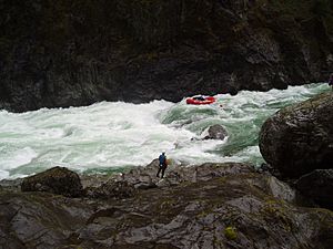
Rafting the Green Wall Rapids on the Illinois River
|
|
|
Location of the mouth of the Illinois River in Oregon
|
|
| Country | United States |
| State | Oregon |
| County | Josephine and Curry |
| Physical characteristics | |
| Main source | Confluence of East Fork Illinois River and West Fork Illinois River near Cave Junction, Josephine County, Oregon 1,271 ft (387 m) 42°09′35″N 123°39′33″W / 42.15972°N 123.65917°W |
| River mouth | Rogue River Agness, Curry County, Oregon 102 ft (31 m) 42°33′00″N 124°03′58″W / 42.55000°N 124.06611°W |
| Length | 56 mi (90 km) |
| Basin features | |
| Basin size | 983 sq mi (2,550 km2) |
| Type: | Wild, Scenic, Recreational |
| Designated: | October 19, 1984 |
The Illinois River is a river in Oregon, USA. It is about 56 miles (90 km) long. This river flows into the Rogue River. It helps drain water from the Klamath Mountains in northern California and southwestern Oregon.
The main part of the river starts where its East Fork and West Fork join together. This spot is near Cave Junction in southern Josephine County. The area of land that collects water for the river is called its drainage basin. This basin includes a stream called Sucker Creek. The Illinois River then flows generally northwest. It winds its way past Kerby and through the Siskiyou National Forest and Kalmiopsis Wilderness. Finally, it joins the Rogue River at Agness. This meeting point is about 27 miles (43 km) from the Pacific Ocean.
Contents
Protecting the Illinois River
A large part of the Illinois River is special. About 50.4 miles (81.1 km) of its lower section is protected. This section starts downstream from Kerby, where the river enters the Rogue River–Siskiyou National Forest. It ends where the Illinois River meets the Rogue River.
This part of the river was named "Wild and Scenic" in 1984. This means it is kept in its natural state. About 28.7 miles (46.2 km) is protected as "wild." This means it's very untouched by humans. Another 17.9 miles (28.8 km) is "scenic," offering beautiful views. The last 3.8 miles (6.1 km) is "recreational," meaning it's good for outdoor activities.
River Branches and Names
Sucker Creek
Sucker Creek is one of the smaller streams that flows into the Illinois River. It got its name from the state of Illinois. One of Illinois's nicknames is "the Sucker State." Miners from Illinois gave the creek its name a long time ago.
In 2011, the United States Forest Service worked on Sucker Creek. They started a project to make the creek better for fish. This project helps improve the fish habitat in the area.
Adventure on the Illinois River
Rafting and Kayaking Challenges
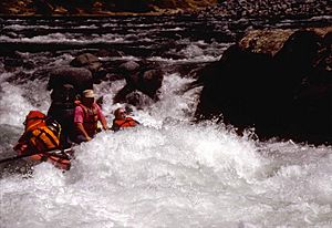
The Illinois River is known as a "wilderness river." It's a challenging place for people who love to raft or kayak. The river tests both their skills and strength. There's a 31 miles (50 km) stretch along the Wild and Scenic part of the river. This section is between upper Oak Flat near Kerby and lower Oak Flat. Here, boaters are very far from any trails or roads.
It's one of the most remote river canyons in the lower 48 states. Some parts are so hard to reach, even by walking trails. This part of the river has eight difficult rapids. These are rated as Class IV to IV+. One rapid, called Green Wall, is a Class V. It is much harder and longer than the others. Below Green Wall, there are 3 miles (4.8 km) more of tough rapids.
Best Time for Boating
People usually raft or kayak on the Illinois River during the rainy season. This is from October through April. If the water flow is too low (below 800 cubic feet per second (23 m3/s)), boating becomes hard. This is because many rocks are exposed. If the water flow is too high (above 3,000 cubic feet per second (85 m3/s)), the river turns into boiling holes and powerful rapids. A lot of rain can quickly change a normal trip into a dangerous high-water adventure.
Permits and Safety
You need a permit from the U.S. Forest Service to go on river trips. This is for the Wild Section of the river, between Briggs Creek and Nancy Creek. Permits are required all year round. Groups are limited to no more than twelve people.
For non-commercial groups, the permits are free. You can get them yourself at any time. You must also leave your permit at Oak Flat when you finish your trip. This helps to confirm that your trip was completed safely.
The Illinois River does not have a dam. This means the water levels depend completely on the weather. Changing weather can cause the water to be too high or too low for a safe trip. Water levels can rise very quickly. Bad weather can cause trips to be canceled or postponed. Even when conditions seem good, the Illinois River can still be very challenging.
 | Jewel Prestage |
 | Ella Baker |
 | Fannie Lou Hamer |


