
Oacoma, South Dakota facts for kids
Quick facts for kids
Oacoma, South Dakota
|
|
|---|---|

Downtown Oacoma
|
|
| Motto(s):
"One Day Just Isn't Enough"
|
|

Location in Lyman County and the state of South Dakota
|
|
| Country | United States |
| State | South Dakota |
| County | Lyman |
| Founded | 1890 |
| Area | |
| • Total | 4.19 sq mi (10.86 km2) |
| • Land | 2.60 sq mi (6.75 km2) |
| • Water | 1.59 sq mi (4.11 km2) |
| Elevation | 1,401 ft (427 m) |
| Population
(2020)
|
|
| • Total | 386 |
| • Density | 148.23/sq mi (57.22/km2) |
| Time zone | UTC-6 (Central (CST)) |
| • Summer (DST) | UTC-5 (CDT) |
| ZIP code |
57365
|
| Area code(s) | 605 |
| FIPS code | 46-46180 |
| GNIS feature ID | 1267519 |
Oacoma is a small town located in Lyman County, South Dakota, in the United States. It sits right on the west side of the Missouri River, directly across from the town of Chamberlain. In 2020, about 386 people lived here.
Contents
History of Oacoma
Oacoma has a long and interesting history, especially because of its location by the Missouri River.
Early Explorers and Traders
On September 17, 1804, famous explorers Lewis and Clark set up camp near where Oacoma is today. They stayed on the west bank of the Missouri River, close to a place called American Island. For the rest of the 1800s, this area was a popular stop for many different people. Explorers, fur traders, and even steamboat crews would often pause here during their journeys.
Founding and Growth
The town of Oacoma was officially planned out in 1891. It was chosen to be the main town, or "county seat," for the newly formed Lyman County. However, in 1922, the county seat was moved to Kennebec.
In 1905, the Chicago, Milwaukee, St. Paul and Pacific Railroad reached Oacoma. This made the town an important "banking post-village," meaning it was a place where people could do banking and send mail.
Oacoma Today
Today, Oacoma is still a busy place for travelers. It serves as a convenient rest stop for people driving on Interstate 90, especially those traveling between Sioux Falls and Rapid City.
Geography of Oacoma
Oacoma is located in a scenic area of South Dakota.
Land and Water
The town covers a total area of about 4.18 square miles (10.8 square kilometers). A good portion of this area is land, about 2.59 square miles (6.7 square kilometers). The rest, about 1.59 square miles (4.1 square kilometers), is water. This water area is mainly due to the town's location on the Missouri River.
Rivers and Creeks
A small river called American Crow Creek flows into the Missouri River right in Oacoma. This creek is a tributary, which means it's a smaller stream that flows into a larger one.
Population and People
Understanding the population of Oacoma helps us see how the town has grown and changed over time.
Population Changes Over Time
The number of people living in Oacoma has changed quite a bit through the years. Here's a look at the population counts from different years:
| Historical population | |||
|---|---|---|---|
| Census | Pop. | %± | |
| 1910 | 235 | — | |
| 1920 | 224 | −4.7% | |
| 1930 | 167 | −25.4% | |
| 1940 | 197 | 18.0% | |
| 1950 | 231 | 17.3% | |
| 1960 | 312 | 35.1% | |
| 1970 | 215 | −31.1% | |
| 1980 | 289 | 34.4% | |
| 1990 | 367 | 27.0% | |
| 2000 | 390 | 6.3% | |
| 2010 | 451 | 15.6% | |
| 2020 | 386 | −14.4% | |
| U.S. Decennial Census | |||
Who Lives in Oacoma?
Based on the 2010 census, there were 451 people living in Oacoma. These people made up 205 households, with 135 of those being families.
Most of the people in Oacoma (about 88.9%) were White. There were also people who identified as Native American (6.4%), African American (0.2%), Asian (0.4%), or from other backgrounds. About 1.8% of the population identified as Hispanic or Latino.
The average age of people in Oacoma in 2010 was about 44.3 years old. About 19.7% of the residents were under 18, and 15.3% were 65 or older. The town had a slightly higher number of males (52.5%) than females (47.5%).
Images for kids
-
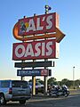
Al's Oasis, a popular stopping place in Oacoma along Interstate 90.

See also
 In Spanish: Oacoma (Dakota del Sur) para niños
