
Oakdale, Tennessee facts for kids
Quick facts for kids
Oakdale, Tennessee
|
|
|---|---|

Buildings in Oakdale
|
|

Location of Oakdale in Morgan County, Tennessee.
|
|
| Country | United States |
| State | Tennessee |
| County | Morgan |
| Settled | before 1880 |
| Incorporated | 1887 |
| Charter Repealed | 1895 |
| Incorporated | 1911 |
| Area | |
| • Total | 0.90 sq mi (2.32 km2) |
| • Land | 0.87 sq mi (2.26 km2) |
| • Water | 0.02 sq mi (0.06 km2) |
| Elevation | 991 ft (302 m) |
| Population
(2020)
|
|
| • Total | 191 |
| • Density | 218.54/sq mi (84.41/km2) |
| Time zone | UTC-5 (Eastern (EST)) |
| • Summer (DST) | UTC-4 (EDT) |
| ZIP code |
37829
|
| Area code(s) | 423 |
| FIPS code | 47-54280 |
| GNIS feature ID | 2407024 |
Oakdale is a small town in Morgan County, Tennessee, United States. It is located along the Emory River. In 2020, about 191 people lived there.
History of Oakdale
Oakdale was first known as "Honeycutt." This name came from an early settler named Allen Honeycutt. In the 1880s, a railroad called the Cincinnati Southern Railway was built. This railway connected Chattanooga and Cincinnati. It crossed another big railway system, the East Tennessee, Virginia and Georgia Railroad, near Harriman.
Allen Honeycutt gave land to the railroad. This land was used to build a special place where trains could switch tracks. In 1892, the town's name was changed to "Oakdale." This new name came from a nearby mining area.
The railway section from Oakdale to Somerset, Kentucky had very steep hills. Old steam trains found it hard to climb these hills. So, a train yard was built in Oakdale. Here, trains were changed to help them make the tough trip north.
By the early 1900s, Oakdale became an important railroad town. It had many businesses like a bank, stores, and a drugstore. There were also three schools, two churches, and even a newspaper. The railroad also built a large hotel called the Babahatchie Inn in 1880. "Babahatchie" was the first name for the Emory River. The hotel burned down in 1892 but was rebuilt.
In 1905, this hotel became one of the biggest YMCA buildings in the country. It had 1,500 beds, its own library, and a clinic. Oakdale officially became a town in 1887. However, the state took away its town status in 1895. It became a town again in 1911.
Later, new diesel locomotives were invented. These trains could handle the steep hills easily. This meant the Oakdale train yard was no longer needed. Because of this, the town became smaller in the mid-1900s. In the 1970s, a park and tennis courts were built. A new bridge over the Emory River was finished in 1999. Today, students from pre-kindergarten to 12th grade attend Oakdale School.
Geography of Oakdale
Oakdale is located along the Emory River. It is in a hilly area on top of the Cumberland Plateau. The town is mainly in two parts, one on each side of the river.
The western part of town is on a slope. This slope goes down from State Route 299 to a flat area near the river. This side has the town hall, fire department, and some houses. The eastern part is in a valley north of State Route 299. This side has a post office, a park, and more houses.
State routes 299 and 328 meet at the southern edge of town. SR 328 is east of the river. It connects Oakdale to Harriman in the south and US 27 in the north. SR 299 crosses the river. It connects Oakdale to I-40 and the Westel area in Cumberland County to the southwest.
The town covers a total area of about 0.9 square miles (2.3 km2). Most of this area is land, about 0.9 square miles (2.3 km2). A small part, about 0.04 square miles (0.10 km2), is water.
Population and People
| Historical population | |||
|---|---|---|---|
| Census | Pop. | %± | |
| 1920 | 1,552 | — | |
| 1930 | 1,123 | −27.6% | |
| 1940 | 900 | −19.9% | |
| 1950 | 718 | −20.2% | |
| 1960 | 470 | −34.5% | |
| 1970 | 376 | −20.0% | |
| 1980 | 323 | −14.1% | |
| 1990 | 268 | −17.0% | |
| 2000 | 244 | −9.0% | |
| 2010 | 212 | −13.1% | |
| 2020 | 191 | −9.9% | |
| Sources: | |||
In 2000, there were 244 people living in Oakdale. There were 92 households and 64 families. The population density was about 268.2 inhabitants per square mile (103.6/km2).
About 31.5% of households had children under 18. The average household had about 2.65 people. The average family had about 3.25 people.
The median age in the town was 35 years old. About 28.3% of the people were under 18. About 9.0% were 65 or older.
The median income for a household was $26,667. For families, it was $27,083. About 11.6% of the people and 10.1% of families lived below the poverty line.
Images for kids
-
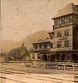
The Babahatchie Inn
-
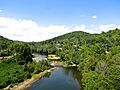
Emory River in Oakdale
-
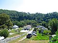
Houses in Oakdale


See also
 In Spanish: Oakdale (Tennessee) para niños
