Oakfield, New York facts for kids
Quick facts for kids
Oakfield, New York
Oak Orchard
|
|
|---|---|

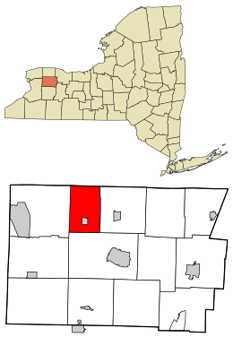
Location in Genesee County and the state of New York.
|
|
| Country | United States |
| State | New York |
| County | Genesee |
| Government | |
| • Type | Town Council |
| Area | |
| • Total | 23.93 sq mi (61.99 km2) |
| • Land | 23.31 sq mi (60.37 km2) |
| • Water | 0.62 sq mi (1.62 km2) |
| Population
(2010)
|
|
| • Total | 3,250 |
| • Estimate
(2016)
|
3,134 |
| • Density | 134.45/sq mi (51.91/km2) |
| Time zone | UTC-5 (Eastern (EST)) |
| • Summer (DST) | UTC-4 (EDT) |
| FIPS code | 36-037-54166 |
Oakfield is a town located in Genesee County, New York, in the United States. In 2010, about 3,250 people lived there. The town gets its name from the many oak trees found in the area. Oakfield is on the northern edge of Genesee County. There is also a village inside the town, which is also called Oakfield.
Contents
History of Oakfield
Long ago, before European settlers arrived, Native Americans lived in the Oakfield area. Old earthworks, which are shapes made in the ground, show that people lived here a very long time ago. The local tribe during more recent times was the Seneca people. They used to cut down trees in a special way, which led to the area being called "Oak Orchard." This name is still used today.
The first settlers arrived around 1801, and they called the area "Plain Brook." Later, in 1842, the town was officially formed from a part of the town of Elba. It was then given the name "Oakfield."
In 1858, a community within the town called Caryville decided to become its own separate village. It was then named the village of Oakfield.
Geography of Oakfield
The town of Oakfield covers about 23.9 square miles (62.0 square kilometers). Most of this area, about 23.5 square miles (60.7 square kilometers), is land. The rest, about 0.5 square miles (1.2 square kilometers), is water.
The Oak Orchard Creek flows through the northern part of the town. The northern border of the town is also the border of Orleans County, specifically the town of Barre.
Population of Oakfield
| Historical population | |||
|---|---|---|---|
| Census | Pop. | %± | |
| 1850 | 1,457 | — | |
| 1860 | 1,595 | 9.5% | |
| 1870 | 1,471 | −7.8% | |
| 1880 | 1,495 | 1.6% | |
| 1890 | 1,441 | −3.6% | |
| 1900 | 1,589 | 10.3% | |
| 1910 | 2,115 | 33.1% | |
| 1920 | 2,438 | 15.3% | |
| 1930 | 3,115 | 27.8% | |
| 1940 | 2,896 | −7.0% | |
| 1950 | 3,041 | 5.0% | |
| 1960 | 3,388 | 11.4% | |
| 1970 | 3,364 | −0.7% | |
| 1980 | 3,213 | −4.5% | |
| 1990 | 3,312 | 3.1% | |
| 2000 | 3,203 | −3.3% | |
| 2010 | 3,250 | 1.5% | |
| 2016 (est.) | 3,134 | −3.6% | |
| U.S. Decennial Census | |||
In 2010, the town of Oakfield had 3,250 people living there. There were 1,390 households, which are groups of people living together in one home. About 31.2% of these households had children under 18 years old.
The people living in Oakfield are of different ages. About 27.8% of the population was under 19 years old. About 12.9% of the people were 65 years old or older. The average age of people in Oakfield was about 38.7 years.
Places in Oakfield
There are several interesting places and communities within the town of Oakfield:
- Dunhams Grove – This used to be a specific spot in the town. It's where Lewiston Road crosses Oakfield-Batavia Townline Road.
- East Oakfield – This is a small community, or hamlet, located on Lockport Road. It is east of the village of Oakfield.
- Five Corners – This spot was once known as "Oakfield Corners." It is located northwest of the village of Oakfield.
- Oak Orchard Wildlife Management Area – This is a special area set aside to protect wildlife. It is in the northern part of the town.
- Oakfield – This is the main village within the town. It was first called "Plain Brook," then "Caryville," before becoming the village of Oakfield in 1858. It is located on NY-63.
See also
 In Spanish: Oakfield (Nueva York) para niños

