
Obfelden facts for kids
Quick facts for kids
Obfelden
|
||
|---|---|---|
 |
||
|
||

Obfelden
Location in Switzerland

Obfelden
Location in Canton of Zurich
|
||
| Country | Switzerland | |
| Canton | Zurich | |
| District | Affoltern | |
| Area | ||
| • Total | 7.54 km2 (2.91 sq mi) | |
| Elevation | 430 m (1,410 ft) | |
| Population
(Dec 2020 )
|
||
| • Total | 5,779 | |
| • Density | 766.4/km2 (1,985.1/sq mi) | |
| Postal code |
8912
|
|
| Surrounded by | Affoltern am Albis, Hünenberg (ZG), Maschwanden, Merenschwand (AG), Mettmenstetten, Ottenbach | |

Obfelden (which people in Swiss German call Obfälde) is a town in Switzerland. It's located in the Affoltern district, which is part of the Zürich area.
History of Obfelden
Obfelden is the newest town in the Affoltern district. But people have lived here for a very long time, even since the 400s AD!
The area started as five small villages:
- Bickwil (first mentioned in 1246)
- Oberlunnern and Unterlunnern (mentioned in 1257)
- Wolsen (mentioned in 1311)
- Toussen (mentioned in 1325)
These five villages were known as being "ob dem Feld," which means "over the field." This name came from the nearby town of Ottenbach. Most of these villages were controlled by Maschwanden. But Toussen and part of Unterlunnern were under a different area called the Zürich Freiamt.
In the 1500s, both of these areas became part of Knonau (which is now the Affoltern district). The villages of Obfelden then became part of the church area of Ottenbach.
In the 1800s, the people in these villages wanted to create their own town. So, in 1847, Obfelden officially became its own community. A new church was finished the next year. The separate village councils were finally closed in 1877.
The town's special symbol, its coat of arms, shows this history. It has five ears of wheat. These represent the five original villages. A band holds them together, showing how they all joined to form the new town around the church.
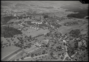
Geography of Obfelden
Obfelden covers an area of about 7.6 square kilometers (or 2.9 square miles).
- Over half of the land (54.3%) is used for farming.
- About a quarter (22.6%) is covered by forests.
- Another part (20.1%) has buildings or roads.
- A small amount (2.9%) is non-productive land, like rivers.
The town is located by the Reuss River. It's also right on the border with the Canton of Aargau. Obfelden is made up of five smaller communities: Bickwil, Oberlunnern, Unterlunnern, Wolsen, and Toussen.
People of Obfelden
Obfelden has a population of 5,779 people. About 16% of the people living here are from other countries. Over the last 10 years, the number of people living in Obfelden has grown by about 7.6%.
Most people in Obfelden (89.6%) speak German. Italian is the second most common language (3.9%), and Albanian is third (1.7%).
In the 2007 election, the most popular political group was the SVP. They received 38% of the votes. Other popular groups included the SPS (15.6%), the FDP (12%), and the CSP (11.5%).
Here's how the age groups are divided in Obfelden:
- Children and teenagers (0–19 years old) make up 25.9% of the population.
- Adults (20–64 years old) make up 64.4%.
- Seniors (over 64 years old) make up 9.7%.
About 78.4% of adults in Obfelden (ages 25–64) have finished high school or gone on to higher education, like a university.
Obfelden has a low unemployment rate of 2%. In 2005, there were:
- 90 people working in farming and related businesses. There were about 26 businesses in this area.
- 334 people working in manufacturing and industry. There were 57 businesses in this area.
- 659 people working in services (like shops, offices, and healthcare). There were 130 businesses in this area.
Here's a look at how Obfelden's population has changed over time:
| year | population |
|---|---|
| 1450 | around 24 Households |
| 1634 | 311 |
| 1668 | 562 |
| 1799 | 789 |
| 1850 | 896 |
| 1900 | 1,335 |
| 1950 | 1,517 |
| 2000 | 4,182 |
Notable Residents
- Mirjam Indermaur, a Swiss author, is from Obfelden.
See also
 In Spanish: Obfelden para niños
