Ohio Pass facts for kids
Quick facts for kids Ohio Pass |
|
|---|---|

Ohio Pass
|
|
| Elevation | 10,065 ft (3,068 m) |
| Traversed by | Gunnison County Road 730 (Unpaved road) |
| Location | Gunnison County, Colorado, United States |
| Range | West Elk Mountains |
| Coordinates | 38°50′05″N 107°05′30″W / 38.8347153°N 107.0917150°W |
| Topo map | USGS Mount Axtell |
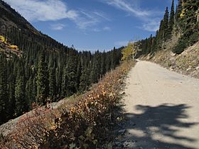
Ohio Pass is a mountain pass in Colorado, USA. It's like a natural gateway through the mountains. This pass is about 10,065 feet (3,068 meters) high. It sits in Gunnison County, Colorado. A road called Gunnison County Road 730 goes right over it. Ohio Pass is found between two peaks, Mount Axtell and Ohio Peak. These peaks are part of the West Elk Mountains. The pass also separates two creeks: Ruby Anthracite Creek to the north and Ohio Creek to the south. It is located one mile southeast of Kebler Pass.
Contents
A Look Back: The History of Ohio Pass
Early Trails and Native Americans
Long ago, in 1874, a group called the Hayden Survey explored this area. They found a clear trail already crossing Ohio Pass. This trail was used by the Ute people. The Ute are a Native American tribe. They had used this mountain path for a long time.
Miners and Wagon Roads
In 1879, many miners came to the area. They were looking for valuable minerals. New mining towns like Ruby and Irwin grew to the north. The miners needed a way to connect with the town of Gunnison to the south. So, a wagon road was built over Ohio Pass. This road helped transport supplies and goods.
Railroad Plans and Abandonment
Later, in 1881, a railroad company started building tracks. This was the Denver, South Park and Pacific Railroad. They planned to lay tracks right over Ohio Pass. But this big project was stopped in 1883. The railroad tracks ended up stopping about 7 miles (11 km) south of the pass. Today, you can still see parts of the old wagon road. You can also spot sections of the unfinished railroad bed. These are especially visible on the south side of the pass.
 | Kyle Baker |
 | Joseph Yoakum |
 | Laura Wheeler Waring |
 | Henry Ossawa Tanner |

