
Olivenhain, Encinitas, California facts for kids
Quick facts for kids
Olivenhain
|
|
|---|---|
|
Neighborhood of Encinitas
|
|

Olivenhain
Location in California
|
|
| Country | United States |
| State | California |
| County | San Diego |
| City | Encinitas |
| Time zone | UTC-8 (Pacific (PST)) |
| • Summer (DST) | UTC-7 (PDT) |
| ZIP codes |
92024
|
| Area code(s) | 760 |
Olivenhain is a lovely neighborhood in Encinitas, California. It's located in the northern part of San Diego County. This area is the easternmost part of Encinitas. It shares a border with Rancho Santa Fe.
Most homes in Olivenhain are large, custom-built houses. They sit on big pieces of land. The land here is hilly, and the streets are often winding. Olivenhain has many trails for walking and horseback riding. You might often see hot air balloons floating in the sky during the late afternoon. The sky in Olivenhain is darker than in other coastal towns. This is because of its "Dark Sky Policy." This policy limits bright lights from streetlights and tennis courts. It helps reduce light pollution.
A Look Back at Olivenhain's History
The land where Olivenhain sits was once part of a Mexican land grant. It was called Rancho Las Encinitas. In the 1890s, a group of German settlers made this area their home. They named it Olivenhain. This name comes from the German words for "olive grove."
The German settlers built a special meeting hall. This building still stands today. It is used for many community events. These include the yearly Oktoberfest and a fun Haunted House. People also enjoy summer movie nights and craft fairs there. Many local groups hold their meetings in the hall. Residents can also rent the Meeting Hall for private events. It's a popular place for weddings.
Originally, Olivenhain was an independent community. But in 1986, it joined with nearby areas. These included Leucadia, Cardiff-by-the-Sea, and Encinitas. Together, they formed the city of Encinitas.
Schools in Olivenhain
Olivenhain is part of two school districts. These are the Encinitas Union School District and the San Dieguito Union High School District.
Younger students attend Olivenhain Pioneer Elementary School. After elementary school, they go to Diegueño Middle School. For high school, public school students attend La Costa Canyon High School or San Dieguito Academy. There are also several private schools nearby for students.
Images for kids
-
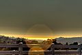
View of the Pacific Ocean from Olivenhain, CA.
-

Hot air balloons are a common sight during late afternoons and dusk over Olivenhain, CA.
-
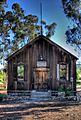
The Olivenhain Meeting Hall.


See also
 In Spanish: Olivenhain (California) para niños
