Olivette, Missouri facts for kids
Quick facts for kids
Olivette, Missouri
|
|
|---|---|

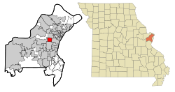
Location of Olivette, Missouri
|
|
| Country | United States |
| State | Missouri |
| County | St. Louis |
| Area | |
| • Total | 2.77 sq mi (7.18 km2) |
| • Land | 2.77 sq mi (7.18 km2) |
| • Water | 0.00 sq mi (0.00 km2) |
| Elevation | 676 ft (206 m) |
| Population
(2020)
|
|
| • Total | 8,504 |
| • Density | 3,068.93/sq mi (1,185.13/km2) |
| Time zone | UTC-6 (Central (CST)) |
| • Summer (DST) | UTC-5 (CDT) |
| FIPS code | 29-54650 |
| GNIS feature ID | 2396056 |
| Website | http://www.olivettemo.com |
Olivette is a city in St. Louis County, Missouri, in the United States. It's like a neighborhood right next to the big city of St. Louis. In 2020, about 8,504 people lived there.
Contents
Discovering Olivette's Past
Olivette started as a small farming area in the mid-1800s. It was located along an old Native American path. This path is now known as Olive Boulevard.
Early Schools and Landmarks
The very first brick schoolhouse in St. Louis County was built in Olivette. This happened in the 1850s. Today, Logos High School stands on the same spot.
Building Stacy Park and the Reservoir
In the 1920s, the city of St. Louis needed a place for a water reservoir. They chose Olivette because it was one of the highest spots around. The reservoir was finished in 1926 at a place called Brock's Pond. This area is now Stacy Park, the biggest park in Olivette.
How Olivette Became a City
Olivette officially became a city in 1930. It was formed by joining four smaller communities. These were Central, Tower Hill, Olive, and Stratmann. Before they joined, the area was often called Central. This was because it was in the middle of an important road. This road connected the Mississippi River and the Missouri River. Wagons used to stop here to get supplies.
Local Services in Olivette
Olivette is special because it has its own fire department. It also has its own police department. Not many communities in St. Louis County do this.
Exploring Olivette's Location
Olivette covers about 2.78 square miles (7.18 square kilometers) of land. It has no large bodies of water.
Major Roads and Neighbors
Some important roads in Olivette include Olive Boulevard and Price Road. Interstate 170 also runs through the city. Olivette has several neighbors. These include Overland to the north and Creve Coeur to the west. To the south is Ladue, and to the east is University City.
Understanding Olivette's Population
| Historical population | |||
|---|---|---|---|
| Census | Pop. | %± | |
| 1940 | 987 | — | |
| 1950 | 1,761 | 78.4% | |
| 1960 | 8,257 | 368.9% | |
| 1970 | 9,156 | 10.9% | |
| 1980 | 7,952 | −13.1% | |
| 1990 | 7,573 | −4.8% | |
| 2000 | 7,438 | −1.8% | |
| 2010 | 7,737 | 4.0% | |
| 2020 | 8,504 | 9.9% | |
| U.S. Decennial Census 2010., 2020 | |||
Population in 2020
In 2020, the 2020 United States census counted 8,504 people living in Olivette. There were 3,114 households. About 25.6% of the people were under 18 years old. The median age was 39.8 years. This means half the people were younger and half were older than 39.8.
Education in Olivette
All public schools in Olivette are part of the Ladue School District.
Local Schools for Students
Old Bonhomme Elementary School is located right in Olivette. Older students attend Ladue High School. There are also private schools in the city. These include Logos High School and Epstein Hebrew Academy. Another private school is Immanuel Lutheran School (Olivette).
Parks and Fun Activities
Stacy Park is a large park in Olivette, covering 35 acres. It's a great place for outdoor activities.
What to Do at Stacy Park
The park has many walking paths for you to explore. There are also fields for different sports. You can find a basketball court and a playground. The park also has picnic areas with BBQs and a public restroom.
Famous People from Olivette
- Sterling K. Brown, a well-known actor
- John Green, an executive at ABC News
- Orlando Cepeda, a famous baseball player in the Hall of Fame
See also
 In Spanish: Olivette (Misuri) para niños
 | William L. Dawson |
 | W. E. B. Du Bois |
 | Harry Belafonte |

