Ladue, Missouri facts for kids
Quick facts for kids
Ladue
|
|
|---|---|
| City of Ladue, Missouri | |

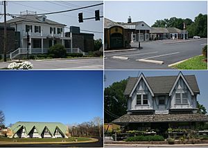
From top left: Busch's Grove, strip mall, Ladue Middle School, Ladue Market
|
|

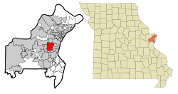
Location of Ladue, Missouri
|
|
| Country | |
| State | |
| County | St. Louis |
| City | St. Louis |
| Incorporated | 1936 |
| Area | |
| • Total | 8.57 sq mi (22.19 km2) |
| • Land | 8.56 sq mi (22.17 km2) |
| • Water | 0.01 sq mi (0.02 km2) |
| Elevation | 561 ft (171 m) |
| Population
(2020)
|
|
| • Total | 8,989 |
| • Density | 1,050.12/sq mi (405.46/km2) |
| Time zone | UTC-6 (Central (CST)) |
| • Summer (DST) | UTC-5 (CST) |
| ZIP codes |
63124
|
| Area code(s) | 314 |
| FIPS code | 29-39656 |
| GNIS feature ID | 2395582 |
| Website | http://www.cityofladue-mo.gov |
Ladue is a city in St. Louis County, Missouri, close to the bigger city of St. Louis. In 2020, about 8,989 people lived there.
Ladue is known for having the highest average household income of any city in Missouri with more than 1,000 people. This means many families in Ladue earn a lot of money.
Contents
Geography and Parks
Ladue covers an area of about 8.55 square miles (22.19 square kilometers). Almost all of this area is land.
A large green space called Tilles Park is located within Ladue. It's a great place for outdoor activities.
Population Facts
Ladue has grown quite a bit over the years. Here's how its population has changed:
| Historical population | |||
|---|---|---|---|
| Census | Pop. | %± | |
| 1940 | 3,981 | — | |
| 1950 | 5,386 | 35.3% | |
| 1960 | 9,466 | 75.8% | |
| 1970 | 10,306 | 8.9% | |
| 1980 | 9,369 | −9.1% | |
| 1990 | 8,847 | −5.6% | |
| 2000 | 8,645 | −2.3% | |
| 2010 | 8,521 | −1.4% | |
| 2020 | 8,989 | 5.5% | |
| U.S. Decennial Census | |||
What the 2020 Census Shows
In 2020, the 2020 United States census counted 8,989 people living in Ladue. Most residents were white (86.65%), with smaller groups of Asian (5.68%) and African-American (1.18%) people. About 5.87% of residents identified with two or more races.
The average age in Ladue was about 49.3 years old. Around 21% of the population was under 18 years old.
What the 2010 Census Shows
The census in 2010 found 8,521 people living in Ladue. The city had about 3,169 households.
Most households (72.6%) were married couples living together. About 36.6% of households had children under 18. The average household had about 2.69 people.
Schools and Learning
The Ladue School District serves students in Ladue and nearby towns like Olivette and Frontenac.
The district includes:
- Ladue Early Childhood Center
- Four elementary schools (Conway, Old Bonhomme, Reed, and Spoede)
- Ladue Fifth Grade Center
- Ladue Middle School
- Ladue Horton Watkins High School
Ladue is also home to two well-known private high schools:
- John Burroughs School
- Mary Institute and St. Louis Country Day School (MICDS)
The main branch of the St. Louis County Library is located in Ladue. It's a great resource for books and learning!
A Look at Ladue's Past
Ladue started as a farming area in St. Louis County. In the late 1800s, families with Irish, German, French, and English backgrounds lived and farmed here.
As cars became popular, farmers began selling parts of their land. People who worked in St. Louis City wanted to live outside the busy urban area.
In 1936, three small villages – LaDue, Deer Creek, and McKnight – joined together. This created the city we now know as Ladue.
The city was named after Ladue Road. This road was the main path from St. Louis City to a large property owned by Peter Albert LaDue. He was a wealthy businessman, lawyer, and banker who came from New York in the 1840s.
Important Legal Cases
Ladue has been involved in some important legal cases that helped define rights in the United States.
Freedom of Speech
In the early 1990s, a resident put up a sign in their yard that shared their opinion about a war. The city tried to make them take it down, saying it broke a city rule.
The American Civil Liberties Union (ACLU) helped the resident. They argued that the city's rule went against the right to free speech protected by the U.S. Constitution.
The case went all the way to the United States Supreme Court. The Supreme Court decided that people have the right to put up signs on their property to express their views. This case is known as City of Ladue v. Gilleo.
Fair Housing Rights
In 1986, the City of Ladue took legal action against some residents because of who was living in their home. The city wanted them to change their living situation.
The Missouri Court of Appeals agreed with the city at the time. However, after this case, a new law was passed in Missouri. This law, called Chapter 213 of the Missouri Human Rights Act, now makes it illegal to discriminate against people in housing based on their "familial status." This means cities cannot tell people who can or cannot live together in a home.
Famous People from Ladue
Many well-known people have lived in Ladue, including:
- Chuck Berry, a famous musician
- Joe Buck, a sports broadcaster
- August Busch III, former chairman of Anheuser-Busch
- Maxine Clark, who founded Build-A-Bear Workshop
- John Danforth, a former U.S. Senator
- William DeWitt, Jr., chairman of the St. Louis Cardinals baseball team
- Jim Edmonds, a former MLB baseball player
- Ezekiel Elliott, a professional football player
- Albert Bond Lambert, an Olympic golfer and the person who helped start Lambert-St. Louis International Airport
- James Smith McDonnell, who founded McDonnell Douglas (now part of Boeing)
- Stan Musial, a Hall of Fame baseball player
- Phyllis Schlafly, a conservative activist
- Andrew C. Taylor, CEO of Enterprise Rent-A-Car
- George Herbert Walker, a well-known businessman
- Jay Williamson, a PGA golfer
Images for kids
See also
 In Spanish: Ladue (Misuri) para niños
 | Emma Amos |
 | Edward Mitchell Bannister |
 | Larry D. Alexander |
 | Ernie Barnes |


