Olmsted Township, Cuyahoga County, Ohio facts for kids
Quick facts for kids
Olmsted Township, Cuyahoga County, Ohio
|
|
|---|---|

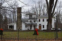
John and Maria Adams House on Columbia Road
|
|

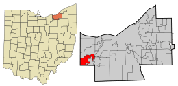
Location in Cuyahoga County and the state of Ohio.
|
|

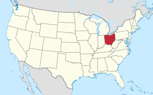
Location of Ohio in the United States
|
|
| Country | United States |
| State | Ohio |
| County | Cuyahoga |
| Area | |
| • Total | 10.0 sq mi (25.9 km2) |
| • Land | 10.0 sq mi (25.9 km2) |
| • Water | 0.0 sq mi (0.0 km2) |
| Elevation | 781 ft (238 m) |
| Population
(2020)
|
|
| • Total | 14,506 |
| • Density | 1,451/sq mi (560.1/km2) |
| Time zone | UTC-5 (Eastern (EST)) |
| • Summer (DST) | UTC-4 (EDT) |
| Area code(s) | 440, 216 |
| FIPS code | 39-58408 |
| GNIS feature ID | 1085988 |
| Website | http://www.olmstedtownship.org/ |
Olmsted Township is a special kind of local government area called a township. It is located in Cuyahoga County, Ohio, in the United States. You can find it in the southwest part of the county. Olmsted Township is a suburb on the west side of Cleveland. It is also part of the larger Greater Cleveland area.
In 2020, about 14,506 people lived in Olmsted Township. It is one of only two townships left in Cuyahoga County. The other one is Chagrin Falls Township. Olmsted Township is also the only township with this name in the entire state of Ohio.
Contents
Where is Olmsted Township Located?
Olmsted Township is in the western part of Cuyahoga County. It shares borders with several nearby cities and townships:
- North Olmsted is to the north.
- Olmsted Falls is to the southeast, west of Berea.
- Berea is to the southeast, east of Olmsted Falls.
- Brook Park is to the northeast.
- Columbia Township in Lorain County is to the south.
- Eaton Township in Lorain County is in the southwest corner.
- North Ridgeville in Lorain County is to the west.
The United States Census Bureau says the township covers a total area of 10.0 square miles. All of this area is land, and there is no water.
Olmsted Township is part of the Cleveland-Elyria-Mentor Metropolitan Statistical Area. In 2010, this larger area had over 2 million people. Olmsted Township is also part of an even bigger area. This is the Cleveland-Akron-Elyria Combined Statistical Area. In 2010, this area had more than 2.7 million people.
A Look Back: The History of Olmsted Township
How Olmsted Township Began
After the American Revolutionary War, the land that became Olmsted Township was part of the Western Reserve. This was a strip of land in northeastern Ohio. It stretched 120 miles west from the Pennsylvania border. The state of Connecticut claimed this land.
In 1795, Connecticut sold most of this land to the Connecticut Land Company. This company then divided the land into townships. They sold these townships by auction. Several people bought parts of what was called Township 6, Range 15. The biggest share, almost half, went to Aaron Olmsted. He was a sea captain from East Hartford, Connecticut.
It took many years for these land sales to be finalized. Aaron Olmsted passed away in 1806. So, when the sale of his land was finished in 1807, it went to his wife and three sons. They then sold parts of the land to people who wanted to settle there.
First Settlers and Naming the Township
In 1814, James Geer, who lived in Columbia Township, planted corn across the border. But it was in 1815 when he and his family truly became the first settlers. They moved into a small log house in Township 6, Range 15.
The township had a few different unofficial names, like Kingston. Then, in 1823, it was officially organized as a civil township called Lenox. However, there was another Lenox Township in Ashtabula County. This caused confusion. So, a resident suggested renaming it Olmsted Township. This was to honor Aaron Olmsted.
Aaron Olmsted's son, Charles Hyde Olmsted, was very happy about this request. He even offered to send the community about 500 books from Connecticut. These books were brought by oxcart. They became famous as the Oxcart Library.
Changes and Growth Over Time
Over the years, parts of Olmsted Township became separate villages and cities.
- On April 7, 1856, Olmsted Falls became a village. It was formed from a part of east-central Olmsted Township.
- In 1857, Olmsted Falls grew bigger. It added Plum Creek, a small community to its north.
- Olmsted Falls continued to add other parts of Olmsted Township over time.
- In 1909, the northern part of Olmsted Township joined with part of southern Dover Township. They formed a new place called North Olmsted.
- In 1927, Westview (also known as West View) became a village. It was formed from the southeastern part of Olmsted Township.
- In 1971, Olmsted Falls and Westview merged. They became one place called Olmsted Falls.
- Other nearby places like Berea, Brook Park, and North Olmsted have also added parts of Olmsted Township land over the years.
Railroad tracks run east-west through the township. These tracks were first built in 1853. Today, they are owned by Norfolk Southern.
Olmsted Township is part of the Olmsted Falls City School District. This school district also includes Olmsted Falls and parts of Berea and Columbia Township.
A company called Vitamix has its main office in Olmsted Township. It is right on the border with Olmsted Falls.
See also
 In Spanish: Municipio de Olmsted para niños
 | Delilah Pierce |
 | Gordon Parks |
 | Augusta Savage |
 | Charles Ethan Porter |

