Ontonagon Indian Reservation facts for kids
Quick facts for kids
Ontonagon Indian Reservation
|
|
|---|---|

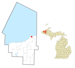
Location within Ontonagon County
|
|
| Country | United States |
| State | Michigan |
| County | Ontonagon |
| Township | Ontonagon |
| Area | |
| • Total | 3.775 sq mi (9.777 km2) |
| Population
(2010)
|
|
| • Total | 0 (permanent) |
| Time zone | UTC−5 (EST) |
| • Summer (DST) | UTC−4 (EDT) |
| ZIP code(s) |
49953 (Ontonagon)
|
| Area code(s) | 906 |
The Ontonagon Indian Reservation is a special homeland for a group of Native Americans known as the Lake Superior Chippewa Tribe. The Chippewa are also called the Ojibwe. Long ago, this tribe had twelve different groups, or "bands," living across Michigan and the Upper Midwest.
In 1934, a law called the Indian Reorganization Act was passed. This law helped Native American tribes manage their own lands and governments. Because of this law, the Ontonagon Band joined with another Ojibwe group. They became part of the Keweenaw Bay Indian Community. This community is officially recognized by the United States government. Today, most of these combined Ojibwe people live on the L'Anse Indian Reservation, which is located at the western end of Lake Superior.
The Ontonagon Reservation itself is found in northeastern Ontonagon Township. This is in northeastern Ontonagon County, right on the south shore of Lake Superior. It's about 20 kilometers (about 12 miles) northeast of the village of Ontonagon, Michigan, in the United States. The reservation covers about 9.777 square kilometers (3.775 square miles) of land. According to the 2010 census, no one lives there permanently. Even though no one lives there all the time, the tribe still has special rights to hunt, fish, and cut timber on their reservation land.
 | Laphonza Butler |
 | Daisy Bates |
 | Elizabeth Piper Ensley |


