Ophir Creek (Lake Washoe) facts for kids
Quick facts for kids Ophir Creek |
|
|---|---|

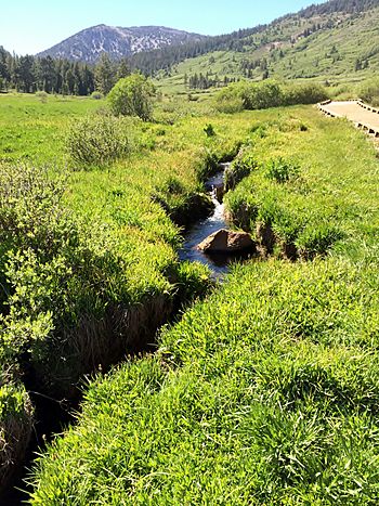
One of several tributaries of Ophir Creek in subalpine Tahoe Meadows with the Carson Range's Relay Peak in distance and the Ophir Creek Trail boardwalk on the right.
|
|
| Country | United States |
| State | Nevada |
| Region | Washoe County |
| Physical characteristics | |
| Main source | Tahoe Meadows south of Mount Rose Summit, a mountain pass of Nevada State Route 431, Carson Range, Sierra Nevada in western Nevada, United States 8,594 ft (2,619 m) 39°18′15″N 119°55′42″W / 39.30417°N 119.92833°W |
| River mouth | Washoe Lake 5,036 ft (1,535 m) 39°17′18″N 119°48′53″W / 39.28833°N 119.81472°W |
Ophir Creek is a 7.7-mile (12.4 km) long stream in Nevada. It flows east through Washoe County. The creek starts in Tahoe Meadows, near Mount Rose Summit. It then travels to Washoe Lake. You can find it in western Nevada.
Contents
History of Ophir Creek
How Ophir Creek Got Its Name
Ophir Creek is named after a big silver discovery. This discovery was made in 1853. It was called the Comstock Ophir bonanza. The name "Ophir" comes from an old story. It was a very rich place in the Bible. King Solomon was said to get gold and silver from there.
To get the silver out, a company built the Ophir Mill. This mill was built in 1861. It was located on the west side of Washoe Lake. Today, a special marker shows where it once stood.
The Story of Price Lakes
There are two lakes connected to Ophir Creek. They are called Upper and Lower Price Lakes. These lakes were named after W. E. Price. He ran a sawmill and was a local leader in 1873. Sadly, in 1983, a big landslide happened. It came from Slide Mountain. This landslide completely filled up Lower Price Lake.
Nature and Wildlife Around Ophir Creek
The Ophir Creek Watershed
A watershed is an area of land. All the water from this land drains into a specific stream or river. Ophir Creek is part of a larger watershed. This includes Steamboat Creek and Washoe Lake. All these waters eventually flow into the Truckee River. The Ophir Creek watershed covers about 6.5 square miles (17 km2).
Two lakes are part of this watershed. They are Upper Price Lake and Rock Lake. Upper Price Lake is at 7,241 feet (2,207 m) high. Rock Lake is at 6,503 feet (1,982 m) high.
Protecting Animals and Plants
In 2009, some land near Ophir Creek was protected. The government bought 69 acres. This land is between Davis Regional County Park and Bowers Mansion County Park. This helps protect the environment.
The land is home to special species. These animals need wetlands or flowing water. One is the Carson Silverspot butterfly. The other is the mountain yellow-legged frog. Protecting this land helps these creatures survive.
There's also an old water channel here. It's called the Ophir Flume. It was built way back in 1856. It still carries water from Ophir Creek. This water goes to farms in the Washoe Valley.
Fun Things to Do at Ophir Creek
Hiking the Ophir Creek Trail
You can hike along the Ophir Creek Trail. To start at the top, park near Nevada State Highway 431. This spot is in Tahoe Meadows. It's about 0.8 miles (1.3 km) from Mount Rose Summit. It's also 7.7 miles (12.4 km) from Incline Village.
From here, you can also get to the Tahoe Rim Trail. The Ophir Creek Trail starts on wooden paths. These paths go through the green Tahoe Meadows. This area is a high-altitude meadow.
The trail then goes down 3.3 miles (5.3 km). It leads to Upper Price Lake. You can turn around here and hike back up. Or, you can keep going down another 4.7 miles (7.6 km). This takes you to the end of the trail. The end is at Davis Creek Regional Park. This park is on the west side of the Washoe Valley. There's a parking area at the park.
 | William L. Dawson |
 | W. E. B. Du Bois |
 | Harry Belafonte |

