Orchard City, Colorado facts for kids
Quick facts for kids
Orchard City, Colorado
|
|
|---|---|

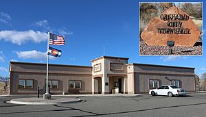
Town hall on 2100 Road
|
|

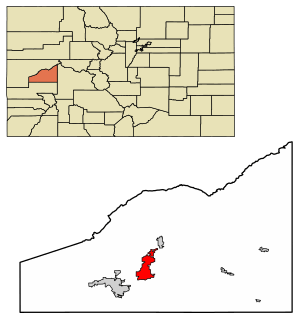
Location of Orchard City in Delta County, Colorado.
|
|
| Country | |
| State | |
| County | Delta |
| Incorporated (town) | May 25, 1912 |
| Government | |
| • Type | Statutory Town |
| Area | |
| • Total | 11.53 sq mi (29.86 km2) |
| • Land | 11.52 sq mi (29.84 km2) |
| • Water | 0.01 sq mi (0.02 km2) |
| Elevation | 5,361 ft (1,634 m) |
| Population
(2020)
|
|
| • Total | 3,142 |
| • Density | 272.51/sq mi (105.22/km2) |
| Time zone | UTC-7 (Mountain (MST)) |
| • Summer (DST) | UTC-6 (MDT) |
| ZIP code |
81410
|
| Area code(s) | 970 |
| FIPS code | 08-55980 |
| GNIS feature ID | 2413088 |
Orchard City is a small town in Delta County, Colorado, United States. It's called a "statutory town" because it follows general laws set by the state of Colorado. In 2020, about 3,142 people lived there.
Even though it's one town, Orchard City is served by three different post offices. These are located in the communities of Austin, Cory, and Eckert. Each of these communities has its own ZIP code.
Contents
Where is Orchard City Located?
Orchard City is in the middle part of Delta County, Colorado. You can find it at these coordinates: 38.816360 degrees North, 107.976951 degrees West.
Colorado State Highway 65 goes right through the town. If you drive southwest on Highway 65 for about 9 miles, you'll reach Delta. Delta is the main city and the county seat for Delta County. If you go northeast for about 6 miles, you'll get to the town of Cedaredge.
The communities of Eckert and Cory are both along Highway 65 within Orchard City. Eckert is in the northern part, and Cory is in the southwest. Austin is in the southeast part of the town. It's located on the north side of Colorado State Highway 92. This highway goes west about 7 miles to Delta and east about 13 miles to Hotchkiss.
The United States Census Bureau says that Orchard City covers a total area of about 11.5 square miles (29.6 square kilometers). Most of this area is land, with only a tiny bit, about 0.01 square miles (0.02 square kilometers), being water.
The Story of Orchard City
Orchard City has an interesting history that goes back to the early 1900s. Back then, people living in the area were getting sick because their drinking water came from ditches. This water wasn't clean.
To solve this problem, three smaller communities decided to work together. These communities were Austin, Cory, and Eckert. They agreed to join forces so they could collect enough money to build a proper water pipeline. This pipeline would bring clean water to everyone.
Because of this agreement, Orchard City was officially formed and became a town in 1912. Even today, many people still refer to the specific communities of Austin, Cory, or Eckert rather than just "Orchard City." The town got its name from an orchard that was located near where the original town was planned.
How Many People Live Here?
The number of people living in Orchard City has grown over the years. Here's a look at the population from different census reports:
| Historical population | |||
|---|---|---|---|
| Census | Pop. | %± | |
| 1920 | 531 | — | |
| 1940 | 865 | — | |
| 1950 | 956 | 10.5% | |
| 1960 | 1,021 | 6.8% | |
| 1970 | 1,163 | 13.9% | |
| 1980 | 1,914 | 64.6% | |
| 1990 | 2,218 | 15.9% | |
| 2000 | 2,880 | 29.8% | |
| 2010 | 3,119 | 8.3% | |
| 2020 | 3,142 | 0.7% | |
As you can see, the population has steadily increased. In 1920, there were just over 500 residents. By 2020, that number had grown to 3,142 people. This shows that more and more people have chosen to make Orchard City their home over the last century.
See also
 In Spanish: Orchard City para niños
 | Aaron Henry |
 | T. R. M. Howard |
 | Jesse Jackson |


