Orcutt, California facts for kids
Quick facts for kids
Orcutt, California
|
|
|---|---|

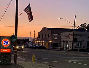
Clark Avenue in downtown Old Orcutt, looking west, between Highways 1 and 135
|
|

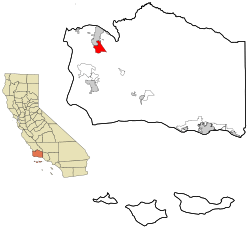
Location in Santa Barbara County and the state of California
|
|
| Country | United States |
| State | California |
| County | Santa Barbara |
| Area | |
| • Total | 11.129 sq mi (28.825 km2) |
| • Land | 11.124 sq mi (28.811 km2) |
| • Water | 0.005 sq mi (0.014 km2) 0.05% |
| Elevation | 358 ft (109 m) |
| Population
(2019)
|
|
| • Total | 31,118 |
| • Density | 2,796.12/sq mi (1,079.55/km2) |
| Time zone | UTC-8 (PST) |
| • Summer (DST) | UTC-7 (PDT) |
| ZIP codes |
93455, 93457
|
| Area code | 805 |
| FIPS code | 06-54120 |
| GNIS feature IDs | 1661153, 2408999 |
Orcutt is a community in Santa Barbara County, California, United States. It's not officially a city, but it's a busy place where many people live. Orcutt is located in the Santa Maria Valley. It was named after William Warren Orcutt, who was important in the oil industry.
In 2010, about 28,905 people lived in Orcutt. The U.S. Census Bureau calls Orcutt a "census-designated place." This means it's a special area used for counting people and collecting statistics.
Contents
History of Orcutt
Orcutt gets its name from William Warren Orcutt. He was a manager for the Union Oil Company. People called him the "Dean of Petroleum Geologists." This means he was a very respected expert in finding oil.
William Orcutt made an amazing discovery. He found fossilized bones of ancient animals in asphalt pools. These pools were on the Hancock Ranch. These were the first fossils found at the famous La Brea Tar Pits. To honor his discovery, scientists named an ancient coyote, Canis orcutti, after him.
Geography and Location
Orcutt covers about 11.1 square miles (28.8 square kilometers). Most of this area is land, with a very small amount of water.
Orcutt started as a small town for oil field workers. It was built along a railroad siding for the Pacific Coast Railway. Today, Orcutt is mostly a bedroom community. This means many people who live here travel to work in nearby Santa Maria. Santa Maria is right next to Orcutt, to the north.
The community is located between two main roads. California State Route 135 is to the east and south. The Cabrillo Highway (Route 1) is to the west. Orcutt was one of the fastest-growing places in Santa Barbara County in 2005.
Orcutt's Climate
Orcutt has a pleasant climate. Summers are warm and dry, but not too hot. The average monthly temperatures usually stay below 71.6°F (22°C). This type of weather is called a warm-summer Mediterranean climate. It's similar to the climate in places around the Mediterranean Sea.
| Climate data for Orcutt, California | |||||||||||||
|---|---|---|---|---|---|---|---|---|---|---|---|---|---|
| Month | Jan | Feb | Mar | Apr | May | Jun | Jul | Aug | Sep | Oct | Nov | Dec | Year |
| Mean daily maximum °F (°C) | 64.2 (17.9) |
64.7 (18.2) |
66.4 (19.1) |
68.6 (20.3) |
70.2 (21.2) |
72.9 (22.7) |
75.2 (24.0) |
76.0 (24.4) |
76.3 (24.6) |
74.8 (23.8) |
69.4 (20.8) |
64.1 (17.8) |
70.2 (21.2) |
| Mean daily minimum °F (°C) | 39.6 (4.2) |
41.7 (5.4) |
43.2 (6.2) |
44.2 (6.8) |
47.3 (8.5) |
50.2 (10.1) |
52.8 (11.6) |
53.4 (11.9) |
51.8 (11.0) |
48.3 (9.1) |
43.3 (6.3) |
38.8 (3.8) |
46.2 (7.9) |
| Average precipitation inches (mm) | 2.89 (73) |
3.45 (88) |
3.10 (79) |
0.93 (24) |
0.32 (8.1) |
0.05 (1.3) |
0.03 (0.76) |
0.05 (1.3) |
0.31 (7.9) |
0.54 (14) |
1.32 (34) |
2.02 (51) |
15.01 (381) |
People Living in Orcutt
The U.S. Census Bureau collects information about the people living in Orcutt. This helps us understand the community better.
Population in 2010
In 2010, Orcutt had a population of 28,905 people. Most of the people living here were White (80.6%). There were also people of other backgrounds, including African American, Native American, and Asian. About 20% of the population was Hispanic or Latino.
The census showed that almost everyone lived in homes. Only a very small number lived in group housing or institutions. There were 10,631 households in Orcutt. Many of these households (34.2%) had children under 18 living in them. The average household had about 2.71 people.
The median age in Orcutt was 42.3 years old. This means half the people were older than 42.3, and half were younger. About 24.3% of the population was under 18 years old.
Most homes in Orcutt (78.1%) were owned by the people living in them. The rest were rented.
Population in 2000
In 2000, Orcutt had 28,830 people. The population density was about 2,551 people per square mile. The racial makeup was similar to 2010, with a majority of White residents (86.68%). About 14.45% of the population was Hispanic or Latino.
There were 10,420 households. About 35.1% of these households had children under 18. The average household size was 2.74 people. The median age was 40 years old.
Education in Orcutt
Children in Orcutt go to schools that are part of the Orcutt Union School District. These schools are known for their good performance. Compared to other schools in California, schools in Orcutt Union School District often rank in the 70th and 80th percentiles. This means they perform better than 70% or 80% of other schools in the state.
Public Safety and Law Enforcement
Since Orcutt is not an official city, its law enforcement is handled by the Santa Barbara County Sheriff's Department. They are responsible for general safety and crime prevention.
Traffic laws and car accident investigations are handled by the California Highway Patrol. Their office is located in nearby Santa Maria. The Santa Barbara County Board of Supervisors oversees the community because it is an unincorporated area.
See also
 In Spanish: Orcutt (California) para niños
 | Emma Amos |
 | Edward Mitchell Bannister |
 | Larry D. Alexander |
 | Ernie Barnes |


