Ordway, Colorado facts for kids
Quick facts for kids
Ordway, Colorado
|
|
|---|---|

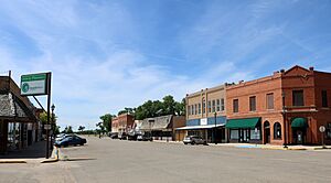
Main Street in Ordway (2017)
|
|

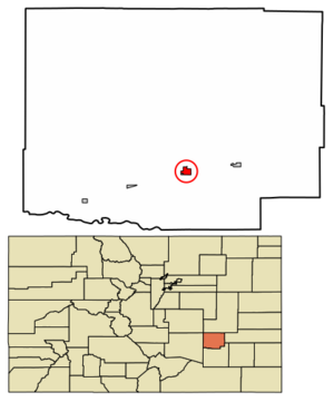
Location within Crowley County and Colorado
|
|
| Country | United States |
| State | Colorado |
| County | Crowley |
| Incorporated | September 4, 1900 |
| Area | |
| • Total | 0.77 sq mi (2.00 km2) |
| • Land | 0.77 sq mi (2.00 km2) |
| • Water | 0.00 sq mi (0.00 km2) |
| Elevation | 4,311 ft (1,314 m) |
| Population
(2020)
|
|
| • Total | 1,066 |
| • Density | 1,384/sq mi (533.0/km2) |
| Time zone | UTC−7 (MST) |
| • Summer (DST) | UTC−6 (MDT) |
| ZIP Code |
81063
|
| Area code | 719 |
| FIPS code | 08-56145 |
| GNIS ID | 203804 |
Ordway is a small town in Crowley County, Colorado, United States. It is the main town and the county seat (the place where the local government is) for Crowley County. In 2020, about 1,066 people lived there, making it the most populated community in the county.
Contents
A Look Back at Ordway's History
Ordway got its first post office, where people could send and receive mail, in 1890. The town was named after George N. Ordway. He was a politician from Denver, which is the capital city of Colorado. The town was officially made a "statutory town" on September 4, 1900. This means it follows specific rules set by the state of Colorado for how towns are run.
Where is Ordway?
Ordway is located in the south-central part of Crowley County. You can find it at these coordinates: 38°13′11″N 103°45′26″W.
Colorado State Highway 96 runs along the southern edge of Ordway. If you drive west on this highway, you'll reach Pueblo in about 49 miles. If you drive east, you'll get to Eads in about 60 miles.
Colorado State Highway 71 is on the eastern side of town. Going south on Highway 71 for about 11 miles will take you to U.S. Route 50 near Rocky Ford. Heading north for about 75 miles will lead you to Interstate 70 at Limon.
The United States Census Bureau says that Ordway covers a total area of about 0.8 square miles (2.0 square kilometers). All of this area is land.
Who Lives in Ordway?
The word "demographics" refers to information about the people who live in a place, like how many there are and how the population changes over time.
The population of Ordway has changed quite a bit over the years. Here's a look at how many people have lived in Ordway during different U.S. Decennial Census counts:
| Historical population | |||
|---|---|---|---|
| Census | Pop. | %± | |
| 1900 | 138 | — | |
| 1910 | 705 | 410.9% | |
| 1920 | 1,186 | 68.2% | |
| 1930 | 1,139 | −4.0% | |
| 1940 | 1,150 | 1.0% | |
| 1950 | 1,290 | 12.2% | |
| 1960 | 1,254 | −2.8% | |
| 1970 | 1,017 | −18.9% | |
| 1980 | 1,135 | 11.6% | |
| 1990 | 1,025 | −9.7% | |
| 2000 | 1,248 | 21.8% | |
| 2010 | 1,080 | −13.5% | |
| 2020 | 1,066 | −1.3% | |
| U.S. Decennial Census | |||
Famous People from Ordway
Some notable people have come from Ordway. One example is Ella Mae Gallavan (1903–1966). She was a pathologist, which is a doctor who studies diseases. Pathologists examine body tissues and fluids to help diagnose illnesses.
See also
 In Spanish: Ordway para niños

