Oroville East, California facts for kids
Quick facts for kids
Oroville East, California
|
|
|---|---|

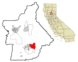
Location in Butte County and the state of California
|
|
| Country | |
| State | |
| County | Butte |
| Area | |
| • Total | 22.324 sq mi (57.819 km2) |
| • Land | 22.149 sq mi (57.365 km2) |
| • Water | 0.175 sq mi (0.454 km2) 0.79% |
| Population
(2020)
|
|
| • Total | 8,038 |
| • Density | 360.061/sq mi (139.020/km2) |
| Time zone | UTC-8 (PST) |
| • Summer (DST) | UTC-7 (PDT) |
| ZIP code |
95965
|
| Area code(s) | 530 |
| FIPS code | 06-54388 |
| GNIS feature IDs | 2409001 |
Oroville East, also known as Kelly Ridge, is a special community in Butte County, California, USA. It's called a census-designated place (CDP) because it's a specific area counted by the government. In 2010, about 8,280 people lived here. This was a bit less than the 8,680 people counted in 2000.
Many people in Oroville East rely on the nearby city of Oroville for shopping and jobs. Most high school students from Kelly Ridge go to Las Plumas High School. The community of Kelly Ridge is right next to Lake Oroville. This means people can easily enjoy boating, camping, fishing, and many other water sports.
Contents
Location and Area of Oroville East
Oroville East is located at 39°30′42″N 121°30′16″W / 39.51167°N 121.50444°W. This is its exact spot on the map.
The United States Census Bureau says that Oroville East covers about 22.3 square miles (57.8 square kilometers) in total. Most of this area, about 22.1 square miles (57.3 square kilometers), is land. A small part, about 0.2 square miles (0.45 square kilometers), is water. This means about 0.79% of the area is water.
Who Lives in Oroville East?
This section shares information about the people living in Oroville East. This data comes from official counts, called censuses.
Population in 2010
The 2010 United States Census showed that 8,280 people lived in Oroville East. There were about 370.9 people per square mile (143.2 people per square kilometer).
Here's a look at the different groups of people:
- Most people, about 6,830 (82.5%), were White.
- About 126 people (1.5%) were African American.
- There were 477 Native American people (5.8%).
- About 294 people (3.6%) were Asian.
- A small number, 8 people (0.1%), were Pacific Islander.
- About 147 people (1.8%) were from other racial backgrounds.
- And 398 people (4.8%) identified as being from two or more races.
- Overall, 702 people (8.5%) were Hispanic or Latino.
Almost everyone, 8,265 people (99.8%), lived in regular homes. Only a very small number lived in group housing.
There were 3,349 homes in Oroville East.
- In 856 homes (25.6%), there were children under 18.
- Most homes, 1,775 (53.0%), had married couples.
- Some homes had a female head of household without a husband (10.4%).
- Others had a male head of household without a wife (5.4%).
- About 25.3% of homes had just one person living there.
- In 14.5% of homes, that single person was 65 years old or older.
- The average number of people in a home was 2.47.
- There were 2,304 families, with an average of 2.91 people per family.
The ages of people living in Oroville East were spread out:
- 1,665 people (20.1%) were under 18 years old.
- 578 people (7.0%) were between 18 and 24.
- 1,490 people (18.0%) were between 25 and 44.
- 2,638 people (31.9%) were between 45 and 64.
- 1,909 people (23.1%) were 65 years old or older.
- The average age was 48.8 years.
- For every 100 females, there were about 97.5 males.
There were 3,674 housing units in total.
- Most homes, 2,701 (80.7%), were owned by the people living in them.
- About 648 homes (19.3%) were rented.
- Most people (77.5%) lived in homes they owned.
- About 22.4% of the population lived in rented homes.
Population in 2000
In the census of 2000, there were 8,680 people living in Oroville East. There were 3,709 homes and 2,618 families. The population density was about 419.6 people per square mile (162.0 people per square kilometer).
There were 4,078 housing units. The average density was 197.1 units per square mile (76.1 units per square kilometer).
The racial makeup of the community in 2000 was:
- 90.65% White
- 0.66% Black or African American
- 3.19% Native American
- 0.92% Asian
- 0.18% Pacific Islander
- 1.39% from other races
- 3.01% from two or more races.
- About 4.56% of the people were Hispanic or Latino.
In 3,709 homes:
- 21.5% had children under 18.
- 59.3% had married couples living together.
- 8.0% had a female head of household with no husband.
- 29.4% were not families.
- 24.8% of all homes had only one person living there.
- 15.0% had someone living alone who was 65 or older.
- The average home size was 2.34 people.
- The average family size was 2.75 people.
The ages of people in 2000 were:
- 20.1% were under 18.
- 4.9% were 18 to 24.
- 19.0% were 25 to 44.
- 28.0% were 45 to 64.
- 27.9% were 65 or older.
- The average age was 49 years.
- For every 100 females, there were 93.6 males.
The average income for a home in 2000 was $41,195. For a family, it was $46,543. The average income per person was $21,508. About 8.2% of all people, and 4.6% of families, lived below the poverty line. This included 15.7% of those under 18 and 4.3% of those 65 or older.
See also
 In Spanish: Oroville East para niños


