Osborn, Missouri facts for kids
Quick facts for kids
Osborn, Missouri
|
|
|---|---|

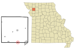
Location of Osborn, Missouri
|
|
| Country | United States |
| State | Missouri |
| Counties | DeKalb, Clinton |
| Area | |
| • Total | 0.57 sq mi (1.48 km2) |
| • Land | 0.57 sq mi (1.48 km2) |
| • Water | 0.00 sq mi (0.00 km2) |
| Elevation | 1,030 ft (310 m) |
| Population
(2020)
|
|
| • Total | 374 |
| • Density | 656.14/sq mi (253.54/km2) |
| Time zone | UTC-6 (Central (CST)) |
| • Summer (DST) | UTC-5 (CDT) |
| ZIP code |
64474
|
| Area code(s) | 816 |
| FIPS code | 29-55352 |
| GNIS feature ID | 2396091 |
Osborn is a city located in the state of Missouri, United States. It is unique because it spans two different counties: Clinton County and DeKalb County. In 2020, the city had a population of 374 people.
The part of Osborn in Clinton County is considered part of the Kansas City Metropolitan Area. The part in DeKalb County is part of the St. Joseph Metropolitan Area.
Contents
History of Osborn
Osborn started to grow because of the Hannibal and St. Joseph Railroad. This railroad was built through the area. The city was named after Colonel William Osborn. He was born in New York in 1809.
Colonel Osborn was a farmer. He also worked as a commissioner for a bank. In 1845, he moved to Missouri. He then partnered with the company that built the Hannibal and St. Joseph Railroad.
Education in Osborn
Students in Osborn attend schools in the Osborn R-0 School District. The school's sports teams are known as the Wildcats. Their team colors are orange and green.
Geography of Osborn
The city of Osborn covers a total area of about 0.57 square miles (1.48 square kilometers). All of this area is land. Osborn is located just south of U.S. Route 36. This is an important road in Missouri.
Population and People
| Historical population | |||
|---|---|---|---|
| Census | Pop. | %± | |
| 1880 | 412 | — | |
| 1890 | 373 | −9.5% | |
| 1900 | 386 | 3.5% | |
| 1910 | 360 | −6.7% | |
| 1920 | 354 | −1.7% | |
| 1930 | 381 | 7.6% | |
| 1940 | 315 | −17.3% | |
| 1950 | 237 | −24.8% | |
| 1960 | 274 | 15.6% | |
| 1970 | 338 | 23.4% | |
| 1980 | 381 | 12.7% | |
| 1990 | 400 | 5.0% | |
| 2000 | 455 | 13.8% | |
| 2010 | 423 | −7.0% | |
| 2020 | 374 | −11.6% | |
| U.S. Decennial Census | |||
The number of people living in Osborn has changed over time. In 1880, there were 412 residents. By 2020, the population was 374 people.
2010 Census Details
According to the census from 2010, 423 people lived in Osborn. There were 192 households in the city. Most residents were White. A small number were Native American or from other backgrounds. About 1.2% of the population was Hispanic or Latino.
Many households were married couples living together. Some households had children under 18 years old. The average age of people in Osborn was about 44 years old.
See also
 In Spanish: Osborn (Misuri) para niños
 | Chris Smalls |
 | Fred Hampton |
 | Ralph Abernathy |

