Osino, Nevada facts for kids
Quick facts for kids
Osino, Nevada
|
|
|---|---|

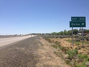
View west along Interstate 80 in Osino,
June 2014 |
|
| Country | United States |
| State | Nevada |
| County | Elko |
| Area | |
| • Total | 2.58 sq mi (6.67 km2) |
| • Land | 2.58 sq mi (6.67 km2) |
| • Water | 0.00 sq mi (0.00 km2) |
| Elevation | 5,157 ft (1,572 m) |
| Population
(2020)
|
|
| • Total | 668 |
| • Density | 259.22/sq mi (100.10/km2) |
| Time zone | UTC-8 (Pacific (PST)) |
| • Summer (DST) | UTC-7 (PDT) |
| ZIP Code |
89801
|
| Area code(s) | 775 |
| FIPS code | 32-53200 |
| GNIS feature ID | 856101 |
Osino is a small community in Elko County, Nevada, United States. It is known as a census-designated place (CDP). This means it is a special area defined by the U.S. Census Bureau for collecting population data. It is not an officially incorporated town.
Osino is located along the Humboldt River. In 2020, about 668 people lived there.

Location and Geography
Osino is found in central Elko County, Nevada. It sits on the northern foothills of two mountain ranges. These are the Elko Hills to the south and the Adobe Range to the west.
The community is right next to Interstate 80. This major highway helps people travel through the area. Osino is about 9 miles northeast of Elko. It is also about 41 miles southwest of Wells.
Population Information
The population of Osino is counted by the U.S. Census Bureau. This helps us understand how many people live in the area.
Population Changes Over Time
The population of Osino has been recorded during different census years.
| Historical population | |||
|---|---|---|---|
| Census | Pop. | %± | |
| 2020 | 668 | — | |
| U.S. Decennial Census | |||
In 2020, the population was 668 people. This information comes from the official U.S. Decennial Census.
See also
- Osino (Nevada) para niños (Osino (Nevada) for children in Spanish)
 | Toni Morrison |
 | Barack Obama |
 | Martin Luther King Jr. |
 | Ralph Bunche |


