Osterley facts for kids
Quick facts for kids Osterley |
|
|---|---|
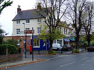
 Shops on Thornbury Road, Osterley |
|
| Population | 13,031 (2011 Census. Osterley and Spring Grove Ward) |
| OS grid reference | TQ145775 |
| London borough | |
| Ceremonial county | Greater London |
| Region | |
| Country | England |
| Sovereign state | United Kingdom |
| Post town | HOUNSLOW |
| Postcode district | TW5 |
| Post town | ISLEWORTH |
| Postcode district | TW7 |
| Dialling code | 020 |
| Police | Metropolitan |
| Fire | London |
| Ambulance | London |
| EU Parliament | London |
| UK Parliament |
|
| London Assembly |
|
Osterley (/ˈɒstərli/ ost-ƏR-lee) is a lovely area in west London, England. It's about 8.7 miles (14.0 km) from Charing Cross, which is the very center of London. Osterley is part of the London Borough of Hounslow.
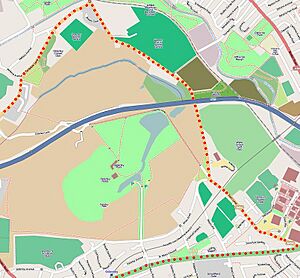
A big part of Osterley is covered by beautiful parks and gardens. These are mostly around Osterley House, which is a historic building. This area is looked after by the National Trust, a charity that protects important places. You can often visit these places, though sometimes there's a small fee.
Osterley is on the highest ground in its local area. It's split by a main road called the A4 (The Great West Road). It even goes further north than the M4 Motorway. Syon Lane forms the eastern edge, and the town of Heston is to the west.
Most of the land in Osterley belongs to the huge Osterley Park estate. This is one of the biggest open spaces in west London. The park and its grand house used to be owned by the Jersey family. During World War II, the house was used as a training school for the Home Guard. Now, it's a National Trust property, meaning it's preserved for everyone to enjoy.
In the 1930s, after the Great West Road was built, new houses started to appear along it. These homes gradually grew into the smaller neighborhoods you see in Osterley today. Besides Osterley House and Park, the area is also known for one of the London homes of The Sultan of Brunei.
The local police have a special team for the Osterley and Spring Grove area. This is part of a program to make neighborhoods safer.
Contents
Sports and Fun
Osterley is a great place for sports lovers!
Football Teams
- There's a local football club called CB Hounslow United F.C.. They play their games at the Osterley Sports Ground.
- The training ground for Premier League club Brentford is also located here. It's at 100 Jersey Road, Osterley.
People and Homes
Let's look at who lives in Osterley and what their homes are like.
Who Lives Here?
In the 2011 Census, about 30% of people in the Osterley area were White British. Other large groups included people of Indian background and other White groups. Overall, about 54% of the population identified as Black, Asian, or from a minority ethnic group.
Most people (51.9%) living in Osterley were born in the U.K. Other common birthplaces include India, Pakistan, Kenya, and Ireland.
Religions in Osterley
The main religions in Osterley are:
- Christians (39.2%)
- Muslims (13.8%)
- Hindus (13.7%)
- Sikhs (11.8%)
About 11.9% of people said they had no religion.
Types of Homes
Here's a look at the types of homes in Osterley in 2011:
| Ward | Detached | Semi-detached | Terraced | Flats and apartments | Caravans/temporary/mobile homes/houseboats | Shared between households |
|---|---|---|---|---|---|---|
| Osterley and Spring Grove | 420 | 1,900 | 467 | 1,981 | 4 | 24 |
This table shows that semi-detached houses and flats are the most common types of homes.
Home Ownership
In 2011, there were 13,031 people living in 4,796 households in Osterley.
| Ward | Population | Households | % Owned outright | % Owned with a loan | hectares |
|---|---|---|---|---|---|
| Osterley and Spring Grove | 13,031 | 4,796 | 29 | 33 | 634 |
This table shows that about 29% of homes were owned outright. Another 33% were owned with a loan.
Getting Around
Osterley has good transport links, making it easy to travel around London and beyond.
Tube and Train Stations
- The nearest London Underground station is Osterley tube station.
- The closest train stations are Syon Lane railway station and Isleworth railway station.
Nearby Places
Osterley is close to many interesting areas:
 |
Norwood Green | Hanwell | Northfields |  |
| Heston | Brentford | |||
| Hounslow | Isleworth | Syon Park, Isleworth |
Kew Gardens, a famous botanical garden, is also only about 20 minutes away.
 | Kyle Baker |
 | Joseph Yoakum |
 | Laura Wheeler Waring |
 | Henry Ossawa Tanner |


