
Otonabee River facts for kids
Quick facts for kids Otonabee River |
|
|---|---|

The Otonabee River in Peterborough, Ontario
|
|

Location of the mouth of the Otonabee River in southern Ontario
|
|
| Native name | Odoonabii-ziibi' |
| Country | Canada |
| Province | Ontario |
| Region | Central Ontario |
| County | Peterborough |
| Cities |
|
| Physical characteristics | |
| Main source | Katchewanooka Lake Selwyn 233 m (764 ft) 44°25′54″N 78°16′19″W / 44.43167°N 78.27194°W |
| River mouth | Rice Lake Otonabee–South Monaghan 187 m (614 ft) 44°09′14″N 78°13′52″W / 44.15389°N 78.23111°W |
| Length | 55 km (34 mi) |
| Basin features | |
| River system | Great Lakes Basin |
| Basin size | 806 km2 (311 sq mi) |
The Otonabee River is a river located in Peterborough County in Central Ontario, Canada. It starts at Katchewanooka Lake near the town of Lakefield. The river then flows through the city of Peterborough before emptying into Rice Lake. This river is part of the larger Great Lakes Basin and is also a key section of the famous Trent–Severn Waterway.
Contents
River Name: What Does Otonabee Mean?
The name of the river, Otonabee, comes from the Ojibwe language. In Ojibwe, the river is called Odoonabii-ziibi.
The word Otonabee is thought to come from two Ojibwe words: ode (meaning "heart") and odemgat (meaning "boiling water"). Together, these words describe "the river that beats like a heart." This name likely refers to the bubbling and boiling water seen in the rapids along the river's path.
River's Journey: Where Does the Otonabee Flow?
The Otonabee River begins its journey at Katchewanooka Lake, which is just north of Lakefield. From there, it flows south, passing over dams and through locks that are part of the Trent-Severn Waterway.
As the river leaves Lakefield, it forms the boundary between Selwyn and the area of Douro–Dummer. It continues south, going through more dams and locks. The river then enters the city of Peterborough.
Passing Through Peterborough
In Peterborough, the Otonabee River flows under the Faryon Bridge, which is near Trent University. Just south of the university, the Trent-Severn Waterway separates from the river for a bit. It uses a special canal to reach the Peterborough Lift Lock, which is east of the river.
The Otonabee River continues its own path south, passing over several hydroelectricity dams. These dams help generate electricity from the river's flow. The river then reaches Little Lake in the center of Peterborough. Here, the Trent-Severn Waterway rejoins the river.
Journey to Rice Lake
After Little Lake, the Otonabee River leaves at the Scotts Mills lock and dam. It then heads south, passing under Ontario Highway 7. The river enters the area of Otonabee–South Monaghan and winds its way without any more locks or dams. Finally, it reaches its mouth at Rice Lake. From Rice Lake, the water flows into the Trent River and eventually into Lake Ontario.
The Otonabee River is about 55 kilometres (34 mi) (about 34 miles) long. The part from Little Lake to Rice Lake is about 30 kilometres (19 mi) (about 19 miles). The area of land that drains into the river, called its drainage basin, is about 806 square kilometres (311 sq mi) (about 311 square miles).
River's Water: Understanding Flooding
Sometimes, after very heavy rains, parts of Peterborough along the Otonabee River can experience flooding. For example, on July 15, 2004, a lot of rain fell in less than 24 hours. This caused the river to overflow its banks in some areas.
History Along the River
Two famous writers, Susanna Moodie and Catharine Parr Traill, once lived on farms close to Katchewanooka Lake, which is where the Otonabee River begins.
Economy: How the River Helps
Trent University has its own hydroelectric plant on the Otonabee River. This plant uses the river's flowing water to create electricity for the university.
Islands in the Otonabee
Cow Island is an island located to the west of where the Otonabee River flows into Rice Lake.
Smaller Streams Joining the River
Many smaller streams, called tributaries, flow into the Otonabee River. Here are some of them:
- Steamboat Creek
- Kent Creek
- Squirrel Creek
- Lepers Creek
- Baxter Creek
- Cavan Creek
- Meade Creek
- Whitlaw Creek
- Jackson Creek
- Sawer Creek
-
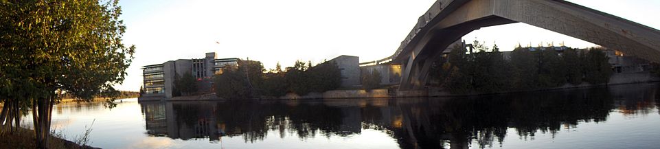
A view across the Otonabee river in Peterborough, Ontario, showing a part of the campus of Trent University. The Faryon bridge is to the right.
-
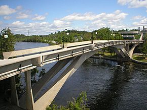
Another view of the Faryon Bridge (reverse angle from previous), connecting the east and west banks of the Otonabee River
-
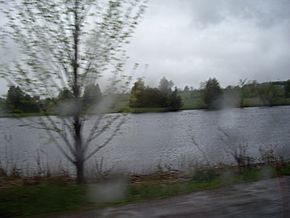
Otonabee River as it flows past Peterborough County Road 32


