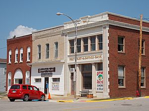
Oxford Junction, Iowa facts for kids
Quick facts for kids
Oxford Junction, Iowa
|
|
|---|---|
 |
|
| Motto(s):
"The junction of opportunity"
|
|

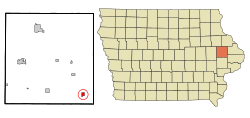
Location of Oxford Junction, Iowa
|
|
| Country | |
| State | |
| County | Jones |
| Area | |
| • Total | 0.65 sq mi (1.68 km2) |
| • Land | 0.65 sq mi (1.68 km2) |
| • Water | 0.00 sq mi (0.00 km2) |
| Elevation | 732 ft (223 m) |
| Population
(2020)
|
|
| • Total | 424 |
| • Density | 654.32/sq mi (252.67/km2) |
| Time zone | UTC-6 (Central (CST)) |
| • Summer (DST) | UTC-5 (CDT) |
| ZIP code |
52323
|
| Area code(s) | 563 |
| FIPS code | 19-60690 |
| GNIS feature ID | 0459977 |
Oxford Junction is a small city located in Jones County, Iowa, United States. According to the 2020 census, 424 people lived there. It is considered part of the larger Cedar Rapids area.
Contents
History of Oxford Junction
Oxford Junction was first planned out in 1871. This happened when a railroad, which no longer exists, was being built. The city got its name because it was located where two different parts of the Chicago, Milwaukee, St. Paul and Pacific Railroad met. This meeting point was called a "junction."
Geography of Oxford Junction
Oxford Junction is located at coordinates 41.983203 degrees North and 90.954480 degrees West. These numbers help pinpoint its exact spot on a map.
The United States Census Bureau says that the city covers a total area of about 0.69 square miles (1.79 square kilometers). All of this area is land, meaning there are no lakes or large rivers within the city limits.
Population and People
| Historical populations | ||
|---|---|---|
| Year | Pop. | ±% |
| 1880 | 349 | — |
| 1890 | 752 | +115.5% |
| 1900 | 780 | +3.7% |
| 1910 | 822 | +5.4% |
| 1920 | 807 | −1.8% |
| 1930 | 759 | −5.9% |
| 1940 | 705 | −7.1% |
| 1950 | 663 | −6.0% |
| 1960 | 725 | +9.4% |
| 1970 | 666 | −8.1% |
| 1980 | 600 | −9.9% |
| 1990 | 581 | −3.2% |
| 2000 | 573 | −1.4% |
| 2010 | 496 | −13.4% |
| 2020 | 424 | −14.5% |
| Source: and Iowa Data Center Source: |
||
2020 Population Details
In 2020, the census showed 424 people living in Oxford Junction. There were 190 households and 105 families. The city had about 654 people per square mile (252.7 people per square kilometer). There were 232 homes in total.
Most of the people in the city were White (96.5%). A small number were Native American (0.5%), or from two or more races (2.4%). About 1.7% of the population was Hispanic or Latino.
About 24.2% of households had children under 18 living with them. Many households (40.5%) were married couples. About 44.7% of all households were not families. This means they were individuals living alone or roommates. About 25.3% of households had someone aged 65 or older living by themselves.
The average age in the city was 45.6 years. About 25.5% of residents were under 20 years old. About 21.5% were 65 years or older. The population was almost evenly split between males (51.7%) and females (48.3%).
2010 Population Details
The 2010 census counted 496 people in Oxford Junction. There were 223 households and 141 families. The population density was about 718.8 people per square mile (277.5 people per square kilometer).
Most people (99.0%) were White. A small number were Native American (0.6%) or Asian (0.4%).
About 26.0% of households had children under 18. Many households (46.2%) were married couples. About 31.8% of households were just one person. About 18.4% of households had a person aged 65 or older living alone.
The average age was 45.5 years. About 22.2% of residents were under 18. Also, 22.2% were 65 or older. The number of males and females was almost equal, with 50.0% male and 50.0% female.
Education
Oxford Junction is part of the Midland Community School District. The city is home to the only elementary school in this district. The Oxford Junction school district joined with the Midland district on July 1, 1995.
See also
 In Spanish: Oxford Junction (Iowa) para niños
 | Laphonza Butler |
 | Daisy Bates |
 | Elizabeth Piper Ensley |

