Paint Rock, Alabama facts for kids
Quick facts for kids
Paint Rock, Alabama
|
|
|---|---|

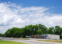
Businesses along US-72 in Paint Rock
|
|

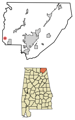
Location of Paint Rock in Jackson County, Alabama.
|
|
| Country | United States |
| State | Alabama |
| County | Jackson |
| Area | |
| • Total | 0.44 sq mi (1.15 km2) |
| • Land | 0.43 sq mi (1.12 km2) |
| • Water | 0.01 sq mi (0.02 km2) |
| Elevation | 610 ft (186 m) |
| Population
(2020)
|
|
| • Total | 182 |
| • Density | 420.32/sq mi (162.12/km2) |
| Time zone | UTC-6 (Central (CST)) |
| • Summer (DST) | UTC-5 (CDT) |
| ZIP code |
35764
|
| Area code(s) | 256 |
| FIPS code | 01-57696 |
| GNIS feature ID | 0154485 |
Paint Rock is a small town located in Jackson County, Alabama, United States. It sits right next to the Paint Rock River. This town is part of the larger Huntsville-Decatur Combined Statistical Area. Paint Rock officially became a town in July 1894.
In 2010, the town had a population of 210 people. This was a small increase from 185 people in 2000. It was the first time in 100 years that the population grew! Paint Rock is the smallest of the 13 towns in Jackson County. Its biggest population was in 1910, when 534 people lived there. At that time, it was the fourth largest town in the county.
History of Paint Rock
Paint Rock was first settled in the 1820s. Back then, it was known as "Camden." A post office was opened in 1836, which helped people send and receive mail. Later, in 1856, a train station was built, making it easier for people and goods to travel. The town's name was changed from Camden to "Paint Rock" in 1876.
A notable person born in Paint Rock was Ray Albright (1934-2017). He was a businessman and also served as a state legislator in Tennessee.
Geography and Location
Paint Rock is located at 34°39′37″N 86°19′41″W / 34.66028°N 86.32806°W. The town is in a valley, which is a low area between mountains. To the west is Keel Mountain, and to the east is the Cumberland Plateau.
Nearby towns include Gurley to the northwest and Woodville to the southeast. Owens Cross Roads is located across Keel Mountain to the southwest. The Fern Cave National Wildlife Refuge, a protected area for wildlife, is just east of Paint Rock. U.S. Route 72, a main highway, goes through Paint Rock. This road connects the town to Scottsboro in the east and Huntsville in the west.
The U.S. Census Bureau says that Paint Rock covers about 0.4 square miles (1.1 square kilometers) of land. There is no water area within the town limits.
Population Information
| Historical population | |||
|---|---|---|---|
| Census | Pop. | %± | |
| 1880 | 41 | — | |
| 1900 | 394 | — | |
| 1910 | 534 | 35.5% | |
| 1920 | 332 | −37.8% | |
| 1930 | 320 | −3.6% | |
| 1940 | 282 | −11.9% | |
| 1950 | 276 | −2.1% | |
| 1960 | 264 | −4.3% | |
| 1970 | 226 | −14.4% | |
| 1980 | 221 | −2.2% | |
| 1990 | 214 | −3.2% | |
| 2000 | 185 | −13.6% | |
| 2010 | 210 | 13.5% | |
| 2020 | 182 | −13.3% | |
| U.S. Decennial Census 2013 Estimate |
|||
In the year 2000, there were 185 people living in Paint Rock. These people lived in 81 different homes, and 57 of these were families. Most of the people living in Paint Rock were White.
About 27% of the homes had children under 18 years old. Many homes (54%) were married couples living together. Some homes (11%) had a female head of household without a husband. About 30% of homes were individuals living alone.
The population was spread out by age. About 18% were under 18 years old. About 14% were between 18 and 24. Around 25% were between 25 and 44, and another 25% were between 45 and 64. About 18% of the population was 65 years or older. The average age in the town was 38 years old.
See also
In Spanish: Paint Rock (Alabama) para niños
 | Dorothy Vaughan |
 | Charles Henry Turner |
 | Hildrus Poindexter |
 | Henry Cecil McBay |


