Woodville, Alabama facts for kids
Quick facts for kids
Woodville, Alabama
|
|
|---|---|

Woodville
|
|

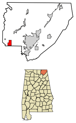
Location of Woodville in Jackson County, Alabama.
|
|
| Country | United States |
| State | Alabama |
| County | Jackson |
| Area | |
| • Total | 6.66 sq mi (17.25 km2) |
| • Land | 6.62 sq mi (17.15 km2) |
| • Water | 0.04 sq mi (0.10 km2) |
| Elevation | 620 ft (189 m) |
| Population
(2020)
|
|
| • Total | 746 |
| • Density | 112.65/sq mi (43.49/km2) |
| Time zone | UTC-6 (Central (CST)) |
| • Summer (DST) | UTC-5 (CDT) |
| ZIP code |
35776
|
| Area code(s) | 256 |
| FIPS code | 01-83664 |
| GNIS feature ID | 0129219 |
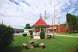
Woodville is a small town in Jackson County, Alabama, United States. It became an official town on December 13, 1819. This was just one day before Alabama became a state!
The town was officially made a city (incorporated) in 1890. However, it lost its official status in 1897. Woodville then became an incorporated town again in 1912. In 2010, the town had a population of 746 people.
Contents
The History of Woodville, Alabama
Woodville was first settled around 1815 by a person named Henry Derrick. It is the oldest town in Jackson County. The town was named after two early residents, Richard and Annie Wood.
In December 1821, Woodville became the main town (county seat) of Decatur County, Alabama. But Decatur County was removed the next year. So, Woodville became part of Jackson County. During the American Civil War, the area around Woodville saw many small battles. One of these was the Skirmish at Paint Rock Bridge.
Woodville's Location and Geography
Woodville is located at 34°37′36″N 86°16′29″W / 34.62667°N 86.27472°W. The town is found along State Route 35. An older part of town is a few blocks west of this road. It sits along County Road 8, facing the railroad tracks.
U.S. Route 72 crosses State Route 35 in the southern part of Woodville. This road connects Woodville to Scottsboro in the east. It also connects to Huntsville in the west. The Cumberland Plateau is a high, flat area just north of Woodville. The Paint Rock River flows just to the west of the town. The Fern Cave National Wildlife Refuge is a special nature area to the northwest.
According to the U.S. Census Bureau, Woodville covers about 6.7 square miles (17.4 square kilometers). All of this area is land.
People and Population in Woodville
| Historical population | |||
|---|---|---|---|
| Census | Pop. | %± | |
| 1880 | 221 | — | |
| 1920 | 191 | — | |
| 1930 | 196 | 2.6% | |
| 1940 | 183 | −6.6% | |
| 1950 | 165 | −9.8% | |
| 1960 | 196 | 18.8% | |
| 1970 | 322 | 64.3% | |
| 1980 | 609 | 89.1% | |
| 1990 | 687 | 12.8% | |
| 2000 | 761 | 10.8% | |
| 2010 | 746 | −2.0% | |
| 2020 | 746 | 0.0% | |
| U.S. Decennial Census 2013 Estimate |
|||
In the year 2000, there were 761 people living in Woodville. These people lived in 301 homes, and 232 of these were families. The town had about 113.7 people per square mile. There were 322 houses in total.
Most of the people in Woodville were White (96.98%). A smaller number were Native American (1.71%) or Asian (0.13%). About 1.18% of people were from two or more races. About 0.92% of the population was Hispanic or Latino.
About 32.2% of homes had children under 18 living there. Most homes (63.5%) were married couples living together. About 10.6% of homes had a female head of household without a husband. About 22.9% of homes were not families.
The average home had 2.53 people. The average family had 2.92 people.
The population was spread out by age. About 24.4% of people were under 18 years old. About 8.9% were between 18 and 24. Around 29.0% were between 25 and 44. About 23.8% were between 45 and 64. And 13.8% were 65 years or older. The average age in Woodville was 36 years.
The average income for a household in Woodville was $35,000. For families, the average income was $37,426. About 9.7% of families and 11.5% of all people lived below the poverty line. This included 11.5% of those under 18 and 20.5% of those 65 or older.
See also

- In Spanish: Woodville (Alabama) para niños
 | May Edward Chinn |
 | Rebecca Cole |
 | Alexa Canady |
 | Dorothy Lavinia Brown |

